
Existed: 1953 – present Constructed 1953 | Length 26.59 km Province British Columbia | |
 | ||
Major cities Surrey, Langley City, Delta | ||
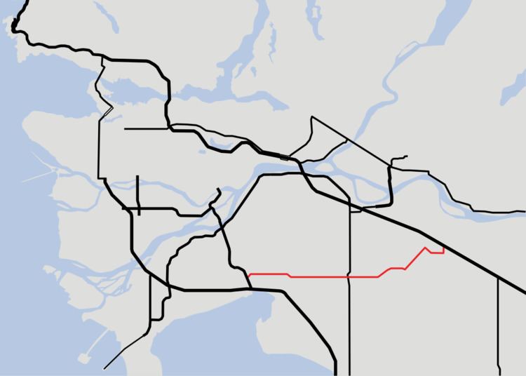
British columbia highway 10 langley bypass to 56 ave surrey bc
Highway 10 is a minor east-west route through the southern portion of Greater Vancouver. Highway 10 is used mainly as a local access route in North Delta, Surrey and Langley. Its former connector role between South Delta and Highway 1 having been taken over by the Highway 17 (South Fraser Perimeter Road).
Contents
- British columbia highway 10 langley bypass to 56 ave surrey bc
- Map of BC 10 British Columbia Canada
- Route details
- History
- Major intersections
- References
Map of BC-10, British Columbia, Canada
Route details
Highway 10 goes for a total length of 26.6 km (16.5 mi) from North Delta to Langley. In the west, Highway 10 begins at the junction with Highway 91; it promptly turns into 58th Avenue. 1.3 km (3⁄4 mi) east of the Highway 91 junction, Highway 10 crosses from Delta into Surrey.
4.5 km (2 3⁄4 mi) east of Scott Road, Highway 10 reaches an intersection with the King George Boulevard (former Highway 99A), turning onto 56th Avenue at the junction. 6.8 km (4 1⁄4 mi) east of the King George Boulevard junction, Highway 10 reaches its intersection with Highway 15 at Cloverdale. 3.5 km (2 1⁄4 mi) east of Highway 15, Highway 10 turns onto the Langley Bypass at 192nd Street, officially crossing from Surrey into Langley 1.4 km (3⁄4 mi), and meets the Fraser Highway (former Highway 1A) another 400 m (1⁄4 mi) east.
2.2 km (1 1⁄4 mi) east of the Fraser Highway, Highway 10 turns northeast onto Glover Road. 3.6 km (2 1⁄4 mi) later, Highway 10 turns east onto Springbrook Road. Highway 10 follows Springbrook Road for 2.4 km (1 1⁄2 mi) east to 232nd Street, then turns north for 900 m (1⁄2 mi) to a junction with Highway 1, at which point Highway 10 finally terminates.
History
Highway 10 was first commissioned in 1953, following its current alignment from Ladner east to Scott Road in Delta/Surrey, then turning north onto Scott Road. In 1967, the highway was re-aligned to go through Langley to a junction with Highway 1 at 232nd Street, and two years later, Highway 10 through the Langley centre was re-routed to a bypass.
In 2003, all sections of Highway 10 west of the Highway 91 interchange were removed from the provincial highway system; this was done to keep large trucks off the road and out of rural Delta. The municipality of Delta now maintains this segment of the old highway, now only known as Ladner Trunk Road (locally, it is still referred to as part of Highway 10).
Major intersections
From west to east. The entire route is in Metro Vancouver.