
Established July 1, 1908 Reference no. 717 Phone +1 626-574-1613 | Governing body U.S. Forest Service Area 2,652 km² | |
 | ||
Website Angeles National Forest Address 701 North Santa Anita Avenue, Headquarters (Not Forest), Arcadia, CA 91006, United States Hours Closed today SaturdayClosedSundayClosedMonday8AM–4:30PMTuesday8AM–4:30PMWednesday8AM–4:30PMThursday8AM–4:30PMFriday8AM–4:30PM Management United States Forest Service Profiles | ||
Exploring angeles national forest hiking los angeles hd
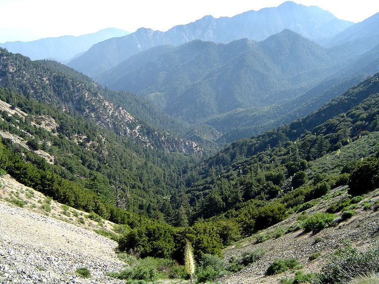
The Angeles National Forest (ANF) of the U.S. Forest Service is located in the San Gabriel Mountains and Sierra Pelona Mountains, primarily within Los Angeles County in southern California. The ANF manages a majority of the San Gabriel Mountains National Monument.
Contents
- Exploring angeles national forest hiking los angeles hd
- Angeles national forest
- Geography
- Wilderness areas
- History
- Wildfires
- Natural history
- Flora
- Access
- General information
- Ranger Districts
- Trails
- Natural features
- Sensitive species
- Mountain peaks
- Water recreation
- Volunteer organizations
- References
The national forest was established in 1908, incorporating the first San Bernardino National Forest and parts of the former Santa Barbara and San Gabriel National Forests. Angeles National Forest headquarters are located in Arcadia, California.
Angeles national forest
Geography
The Angeles National Forest covers a total of 700,176 acres (1,094.0 sq mi; 2,833.5 km2), protecting large areas of the San Gabriel Mountains and Sierra Pelona Mountains. It is located just north of the densely inhabited metropolitan area of Greater Los Angeles.
While primarily within Los Angeles County, a small part extends eastward into southwestern San Bernardino County, in the Mount San Antonio ("Mount Baldy") area, and a tiny section also extends westward into northeastern Ventura County, in the Lake Piru area.
The San Gabriel Mountains National Monument, established in 2014 and managed by the U.S. Forest Service, is largely within the Angeles National Forest.
Wilderness areas
The Angeles National Forest contains five nationally designated wilderness areas. Two of these also extend into neighboring San Bernardino National Forest:
History
The San Gabriel Forest Reserve was established on December 20, 1892, the San Bernardino Forest Reserve on February 25, 1893, and the Santa Barbara Forest Reserve on December 22, 1903. They became National Forests on March 4, 1907, and they were combined on July 1, 1908, with all of the San Bernardino forest and portions of San Gabriel forest and Santa Barbara forest composing the new Angeles National Forest. On September 30, 1925, portions of the Angeles National Forest and the Cleveland National Forest were detached to re-establish the San Bernardino National Forest.
Angeles National Forest is registered as California Historical Landmark #717, for being the first National Forest in the state.
The campgrounds at Broken Blade, Twisted Arrow and Pima Loops were closed on July 26, 2013 after squirrel infected with bubonic plague was discovered.
Wildfires
In the Station Fire, more than 161,000 acres (650 km2) of the forest were burned by an arson fire that began on August 26, 2009, near Angeles Crest Highway in La Cañada and quickly spread, fueled by dry brush that had not burned for over 150 years. The fire burned for more than a month and was the worst in Los Angeles County history, charring one-fourth of the forest (250 square miles), displacing wildlife, and destroying 91 homes, cabins and outbuildings and the family-owned Hidden Springs cafe.
During the fire, two firefighters died after driving off the Mt. Gleason County Road looking for an alternate route to get the inmates out at Camp 16. The Station Fire threatened the Mount Wilson Observatory atop Mt. Wilson . The site includes two telescopes, two solar towers, and transmitters for 22 television stations, several FM radio stations, and police and fire department emergency channels. Although the fire scorched one side of the outhouse at amateur-owned Stony Ridge Observatory, six miles northeast of Mt. Wilson, aside from minor damage from smoke and ash infiltration, the remainder of the observatory and it's historic 30-inch Carroll telescope survived.
Several 2012 wildfires occurred, burning hundreds of acres across the forest-covered mountain range.
Natural history
The Angeles National Forest manages the habitats, flora and fauna ecosystems, and watersheds. Some of the rivers with watersheds within its boundaries provide valuable non-groundwater recharge water for Southern California. The existing protected and restored native vegetation absorb and slow surface runoff of rainwater to minimize severe floods and landslides in adjacent communities. The land within the forest is diverse, both in appearance and terrain. Elevations range from 1,200 to 10,064 ft (365 to 3,067 m). The Pacific Crest Trail crosses the forest.
Flora
Much of this National Forest is covered with dense chaparral shrub forests with oak woodlands, which changes to pine and fir-covered slopes in the higher elevations. Subsequent to the fire there was a heavy growth of "poodle dog bush" ("Eriodictyon parryi"), apparently triggered by the fire's effect on dormant seeds, that lasted for several years. The plant produces prolific lavender flowers. Unfortunately, as visitors to the Forest discovered, contact with it may cause a poison-oak-like rash.
Tree species for which the forest is important include bigcone Douglas-fir (Pseudotsuga macrocarpa), Coulter pine (Pinus coulteri), and California walnut (Juglans californica). The National Forest also contains some 29,000 acres (12,000 ha) of old growth, with: Jeffrey pine (Pinus jeffreyi) forests and mixed conifer forests (Coast Douglas-fir (Pseudotsuga menziesii var. menziesii), ponderosa pine (Pinus ponderosa), and white fir (Abies concolor)), and lodgepole pine (Pinus contorta) the most abundant types.
Access
A National Forest Adventure Pass is required for parking at many locations in the Angeles National Forest and other National Forests in Southern California, and this can be obtained online or from visitor centers and local merchants. Los Angeles County has declared that passes are not required on county-maintained roads. There are also many other areas that do not require the pass.
General information
Ranger Districts
Trails
Natural features
Sensitive species
Mountain peaks
San Gabriel Mountains peaks within the Angeles National Forest include: