
- elevation 4,800 ft (1,463 m) Length 98 km | - elevation 7,500 ft (2,286 m) Discharge 5.38 m³/s Basin area 1,847 km² | |
 | ||
Mouths Pacific Ocean, Alamitos Bay | ||
The San Gabriel River flows 43 miles (69 km) through Los Angeles and Orange Counties, California in the United States. Measured to its highest headwaters in the Angeles National Forest, along the Prairie Fork in the San Gabriel Mountains, the river is 60.6 miles (97.5 km) long, draining a watershed of 713 square miles (1,850 km2). The San Gabriel River basin includes the rugged southern slopes of the San Gabriel Mountains, the urbanized San Gabriel Valley and the similarly developed coastal plain of the Los Angeles Basin.
Contents
- Map of San Gabriel River California USA
- CourseEdit
- EcologyEdit
- WatershedEdit
- HistoryEdit
- FloodsEdit
- River modificationsEdit
- CrossingsEdit
- References
Map of San Gabriel River, California, USA
The river derives its name from the Spanish Mission San Gabriel Arcángel founded in 1771, now in the present day city of San Gabriel. Until the mid-20th century, the river was free flowing with natural banks and a riparian zone habitat lined with forests, marshes, and grasslands for much of its length and a large estuary at its mouth. Today most of the San Gabriel River is channelized, with the section below Whittier Narrows Dam lined by concrete, and impounded in places by debris and flood control dams.
CourseEdit
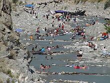
The East, West and North Forks of the San Gabriel River, rising in the San Gabriel Mountains inside the Angeles National Forest, form the source headwaters of the river. The East Fork, sometimes considered part of the main stem, rises in the shadow of Mount San Antonio has two smaller forks of its own, the Prairie Fork and the Fish Fork. The East Fork officially begins at the confluence of the Prairie Fork and a smaller tributary, Vincent Gulch. The Fish Fork and the East Fork combine at the base of Iron Mountain in a canyon nearly 5,000 feet (1,500 m) deep. From there, the East Fork flows south then turns west, flowing into the east arm of San Gabriel Reservoir. The similarly sized West Fork starts near San Gabriel Peak near the Angeles Crest Highway and flows east before being impounded in Cogswell Reservoir, where it receives Devils Canyon Creek. The river continues to flow east and receives Bear Creek from the left before combining with the North Fork, which rises near Mount Islip.
San Gabriel Reservoir and Morris Reservoir, both formed by flood prevention dams built in the 20th Century, submerge most of the upper stretches of the main stem San Gabriel. It is not long after the river leaves the San Gabriel Canyon and exits from the mountains into the San Gabriel Valley near the city of Azusa. The normally dry riverbed proceeds southwest to the Santa Fe Dam, which impounds the river in the Santa Fe Flood Control Basin. After exiting the dam, the river flows south in a flood control channel roughly parallel to Interstate 605, also called the San Gabriel River Freeway, past Covina and El Monte, receives Walnut Creek and San Jose Creek from the left in quick succession, then proceeds into the Whittier Narrows where it is impounded behind Whittier Narrows Dam. Here, the river receives the Rio Hondo from the right, then splits in two immediately after: the main stem continues to flow south, while the Rio Hondo carries a portion of the water southwest to empty into the Los Angeles River near Downey.
The San Gabriel River, however, continues to flow south, past Bellflower and Cerritos. It forms the boundary between Los Angeles and Orange Counties for a brief stretch before merging with Coyote Creek, one of its main tributaries, near Los Alamitos. The river eventually becomes tidal and empties into the outlet of Alamitos Bay between the cities of Long Beach and Seal Beach.
EcologyEdit
The San Gabriel River watershed is in the native range of the steelhead (coastal rainbow trout) (Oncorhynchus mykiss irideus) within the Southern California Distinct Population Segment which has been listed as endangered since 1997. Genetic analysis of the steelhead show them to be of native and not hatchery stocks. Headwaters of the San Gabriel River also hold native resident coastal rainbow trout. The East Fork of the San Gabriel River above Heaton Flat was designated as Wild and Heritage Trout water by the California Fish and Wildlife Department in 2010 to protect the native coastal rainbow trout. The river has been extensively stocked over the years with hatchery strains of rainbow trout as well. Other endemic fish species include the Santa Ana sucker (Catostomus santaanae), and Santa Ana speckled dace (Rhinichthys osculus ssp.). Headwaters of the San Gabriel River, particularly the East Fork and tributaries thereof were designated as critical habitat in 2006 for the endangered Mountain yellow-legged frog (Rana muscosa).
WatershedEdit
The San Gabriel River drains a watershed basin area of 713 square miles (1,850 km2) in eastern Los Angeles County and northwestern Orange County. It is the middle of the three major rivers of the Los Angeles Basin, with its watershed bounded on the west by the Los Angeles River and on the southeast by the Santa Ana River watersheds. To the north is the arid interior endorheic drainage basin of the Mojave Desert and Mojave River. The San Gabriel River mainly flows along the west side of its watershed. There are 37 major cities in the San Gabriel River watershed, 19 of which are actually situated on the river. In total, 26% of the watershed is covered by heavy development. Some tributaries of the river include Brea Creek, Walnut Creek, San Jose Creek, and Coyote Creek. The latter three are all large eastern tributaries that drain areas in excess of 40 square miles (100 km2). San Jose Creek flows nearly 20 miles (32 km) westwards from Pomona into the San Gabriel. Because most of the water from the mountains is stored in reservoirs and diverted for municipal use, the tributaries provide most of the flow below the Santa Fe Dam.
The northern part of the watershed is dominated by the San Gabriel Mountains, one of the Transverse Ranges, which were formed by seismic activity along the San Andreas Fault, a major fault system in turn created by the collision of the North American Plate and the Pacific Plate. Before these two plates collided, the San Gabriel River did not even exist. It was only after the San Gabriel Mountains rose about 75 million years ago, that the river first began to form. Changes in sea level, especially during the Ice Age, deposited thousands of feet of marine sediments in the flood plain south of the San Gabriel Mountains over which the San Gabriel River now flows. The San Rafael Hills, Puente Hills, and Chino Hills that cross the lower part of the watershed were formed by slippage of the Whittier Fault, part of a smaller fault system that formed the Peninsular Ranges.
HistoryEdit
For geologic epochs the river ran freely across semiarid grasslands and through riparian zones and extensive marshes to the Pacific Ocean, flooding in the winter and spring then running nearly dry in the summer and fall. Once out of the mountains, the river's course was subject to large changes due to frequent flooding. The original course before channelization may have followed the present Rio Hondo course and the Los Angeles River course below the Rio Hondo, several miles to the west of today's channel. The Santa Ana River would also occasionally flow into the San Gabriel if floods deposited enough sediment to block its normal channel.
For over 8,000 years, the San Gabriel River basin was part of the homeland of the Tongva—Gabrieleño Native American people. Together with the Los Angeles and Santa Ana Rivers, the San Gabriel River provided sustenance for thousands of members of this powerful coastal tribe whose territory extended across the entire Los Angeles basin, San Fernando Valley, and Channel Islands. The Tongva had permanent settlements and temporary hunting and foraging camps in their territory.
In 1771, the Spanish invaded and founded Mission San Gabriel Arcángel which was originally built on the banks of the Rio Hondo, a tributary of the San Gabriel River in the Whittier Narrows, in 1771. After being flooded in 1776 it was relocated to the location, now in the present day City of San Gabriel. The river's Spanish name is from the mission's. The Spanish colonizers also renamed the Tongva people, as the Gabrieleño Mission Indians after they were relocated to the mission.
After California was admitted to the United States in 1850, the Pueblo de Los Angeles founded in 1781, grew into the City of Los Angeles. In this period, agriculture and ranching, on the lands of the former Spanish and Mexican land grant Ranchos, were the primary economy of the San Gabriel River basin. When the railroads arrived, and especially after the Los Angeles Aqueduct began service in 1913, the development booms in the basin expanded greatly, creating many of the towns and cities that now line the San Gabriel River. Some were named after their founders and others, such as Azusa, derived from the location's Tongva language settlement placename, although the contemporary motto of that city is "everything from 'A' to 'Z' in the 'USA'."
Recently, scientists have discovered a population of green sea turtles swimming year round in the river just south of Los Angeles. It's the northernmost group of these turtles known to science.
A three-mile stretch of the San Gabriel River in Long Beach, CA.
FloodsEdit
Devastating floods wreaked havoc along the San Gabriel River in the late 19th century and the early years of the 20th century. The most famous were the Great Flood of 1862 and the Los Angeles Flood of 1938, which produced some of the highest flows ever recorded in the river. The 1938 flood raised the river to some 150,000 cu ft/s (4,200 m3/s); the 1862 flood may have produced an even higher flow, but its discharge was not recorded. The flood of 1938 would have been far worse if it were not for the dams already on the San Gabriel River, which reduced the peak at Azusa to 65,700 cu ft/s (1,860 m3/s). As a result of the flooding the U.S. Army Corps of Engineers began an ambitious effort to prevent flooding along the river in the lowlands. Much of the river downstream of Azusa was diked, channelized, lined with riprap or paved over with concrete. Drop structures were constructed to reduce flood flow rates and prevent catastrophic erosion of the riverbed. Check dams were constructed in mountain canyons and the river itself was impounded in several large artificial lakes. (See #River modifications.)
The increased flood protection afforded by the dams, stormwater management ponds, and flood control channels led to a housing boom from the 1950s to the 1980s. Most of the lowlands and agricultural areas in the watershed were built and paved over to construct residential, commercial, and industrial districts. Except for the Angeles National Forest protected San Gabriel Mountains and the Puente Hills between the San Gabriel Valley and the Los Angeles Basin, the remaining former flood plain land in the watershed was filled with urban sprawl developments. The river's reservoirs also provide indirect water supply via groundwater recharge operations, which reclaim about 110,000 acre feet (0.14 km3) per year for municipal use.
River modificationsEdit
Like most rivers in Southern California, the San Gabriel River today bears little resemblance to the river it was before the arrival of early Spanish colonial settlers and Californios of Alta California. It is dammed five times along its length: once along the West Fork by the Prescott F. Cogswell Dam, then twice more downstream of the forks in the San Gabriel Mountains to create reservoirs at the San Gabriel Dam, and at the former naval test site Morris Dam; at the Santa Fe Dam in the Santa Fe Dam Flood Control Basin in Irwindale; and with the nearby Rio Hondo (to which it is also connected by a short channel) at the Whittier Narrows Dam, between the cities of South El Monte and Pico Rivera. Its channel is lined with concrete for most of its length below the mountains. These alterations were made in response to disastrous flash floods in the late 19th and early 20th centuries. During periods of heavy rainfall, the Los Angeles District of the U.S. Army Corps of Engineers can shift flows between the Rio Hondo (a tributary of the Los Angeles River) and the San Gabriel River.
The San Gabriel River course is also the site for companion highways. In the lowlands it is adjoined by the San Gabriel River Freeway (Interstate 605) which replaced an older Rivergrade Road. Into the San Gabriel Canyon it is followed by State Route 39 to a terminus nearly 30 miles upstream. Efforts to restore its river ecology and riparian habitats are growing. Historically they have had limited success due to the artificial concrete, water pollution and fertilizer runoff.
CrossingsEdit
From mouth to source (year built in parentheses):