
Governing body U.S. Forest Service Phone +1 909-382-2600 | Area 3,334 km² Established 1907 | |
 | ||
Address San Bernardino, CA 92408, USA Management United States Forest Service Similar Big Bear Discovery Center, San Gorgonio Mountain, Angeles National Forest, San Jacinto Mountains, Jenks Lake Profiles | ||
The San Bernardino National Forest is a United States National Forest in Southern California encompassing 823,816 acres (3,333.87 km2) of which 677,982 acres (2,743.70 km2) are federal. The forest is made up of two main divisions, the San Bernardino Mountains on the easternmost of the Transverse Ranges, and the San Jacinto and Santa Rosa Mountains on the northernmost of the Peninsular Ranges. Elevations range from 2,000 to 11,499 feet (600 to 3505 m). The forest includes five wilderness areas: San Gorgonio, Cucamonga, San Jacinto, Santa Rosa and Bighorn Mountain. Forest headquarters are located in the city of San Bernardino. There are district offices in Lytle Creek, Idyllwild, and Skyforest.
Contents
- Bears playing in water ponds in the san bernardino national forest
- Geography
- Wilderness areas
- Esperanza Fire
- Firefighting aircraft operations
- Vegetation
- References
This site was the filming location for Daniel Boone in 1936; part of the 1969 musical film Paint Your Wagon was shot here.
Free camping is available at 11 different 'Yellow Post' campsites year round.
Bears playing in water ponds in the san bernardino national forest
Geography
According to United States Geological Survey maps of the forest, it consists of two large areas or tracts: a northern and southern portion.
The west border of the forest adjoins Angeles National Forest and runs north-south about ten miles west of Interstate 15. At its widest parts, the northern portion of the forest runs about 57 miles (90 km) on an east–west dimension. It runs about 24 miles (40 km) on a north–south dimension. This portion of the forest encompasses the San Bernardino Mountains. The area extends west of Mount San Antonio, and Wrightwood in San Bernardino County. The eastern portion of the forest extends about ten miles east of Big Bear City and includes the San Gorgonio Wilderness. The southernmost portion is bisected by the Riverside County line and borders the Morongo Indian Reservation north of Cabazon.
At its widest point, the southern portion is about 27 miles (40 km) on a north-south dimension and about 30 miles (50 km) on an east-west dimension. Toro Peak and the Santa Rosa Indian Reservation are near the south extent. At the north is Snow Creek Village and the Morongo Indian Reservation. Mount San Jacinto State Wilderness is carved out of the southern portion. The community of Idyllwild is surrounded by national forest lands.
While most National Forests include lumber resources, these two areas also include:
The two tallest waterfalls in Southern California, Big Falls and Bonita Falls, are located in the San Bernardino National Forest.
Wilderness areas
There are eight official wilderness areas lying within San Bernardino National Forest that are part of the National Wilderness Preservation System. Two of these extend into neighboring Angeles National Forest and three into land that is managed by the Bureau of Land Management (as indicated).
Esperanza Fire
The five-member crew (Mark Loutzenhiser, Jess McLean, Jason McKay, Daniel Hoover-Najera and Pablo Cerda) of the San Bernardino National Forest Alandale Fire Station's Engine 57 was fatally burned by a sudden, intense fire run up a steep drainage below their location during the Esperanza Fire at approximately 7:15 a.m. on October 26, 2006. All five firefighters were overrun by the fire at Twin Pines, located in the San Jacinto Mountains approximately four miles southwest of the City of Cabazon, California. The fire was located near Beaumont, California in Riverside County. Alandale station is located near the community of Idyllwild.
Firefighting aircraft operations
As of 2001, eight Air Tactical Group Supervisors (ATGSs) work out of the Forest Supervisor's Office in San Bernardino. This position requires completion of an 80-hour CDF/Forest Service attack management course. A Helicopter Coordinator (J-374) course is recommended.
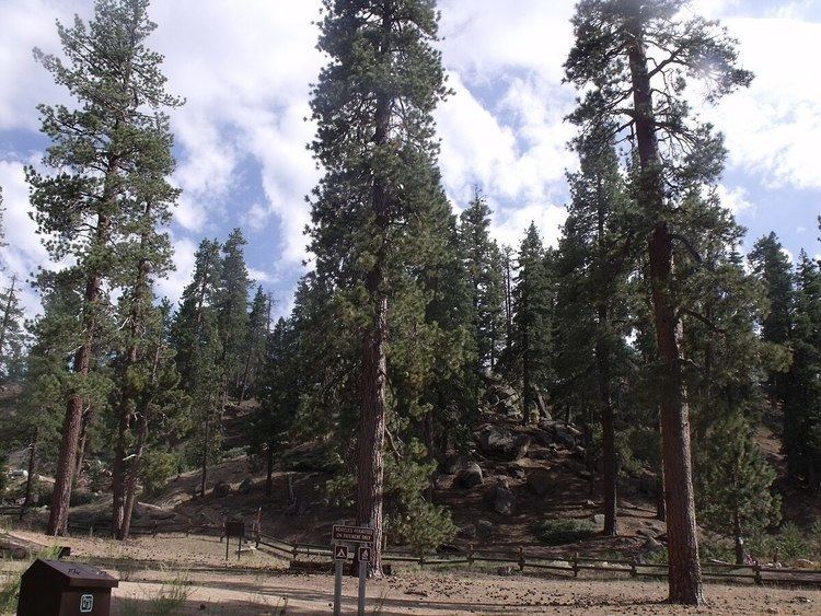
Vegetation
There are many different species of trees, many coniferous, that grow in the mountains. Pines, such as ponderosa pine, Jeffrey pine, sugar pine, Coulter pine, lodgepole pine, single-leaf pinyon, and knobcone pine all thrive here. Other coniferous trees, such as white fir, bigcone Douglas-fir (Pseudotsuga macrocarpa), incense cedar, and western juniper also thrive here. Canyon live oak, California black oak, and Pacific dogwood are other trees that also grow here. The forest contains an estimated 87,400 acres (354 km2) of old growth. The most common old-growth forest types are mixed conifer coast Douglas-fir (Pseudotsuga menziesii var. menziesii), ponderosa pine (Pinus ponderosa), and white fir (Abies concolor) forests, Jeffrey pine (Pinus jeffreyi) forests, and lodgepole pine (Pinus contorta) forests.