
 | ||
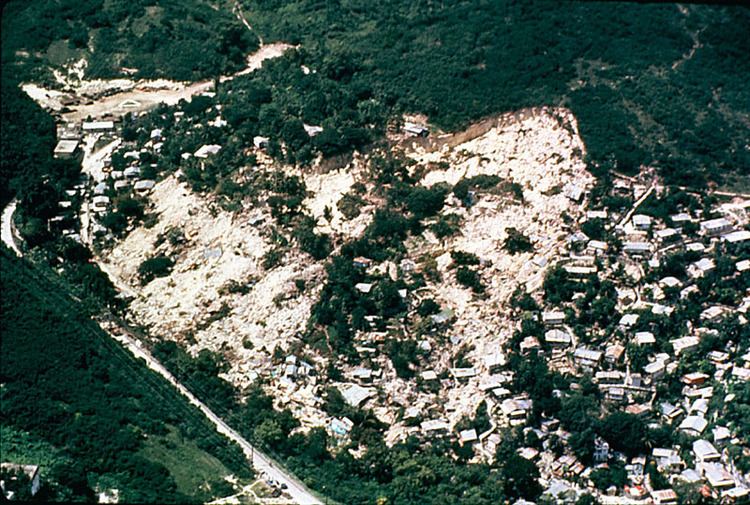
A landslide, also known as a landslip, is a form of mass wasting that includes a wide range of ground movements, such as rockfalls, deep failure of slopes, and shallow debris flows. Landslides can occur underwater, called a submarine landslide, coastal and onshore environments. Although the action of gravity is the primary driving force for a landslide to occur, there are other contributing factors affecting the original slope stability. Typically, pre-conditional factors build up specific sub-surface conditions that make the area/slope prone to failure, whereas the actual landslide often requires a trigger before being released. Landslides should not be confused with mud flows, a form of mass wasting involving very to extremely rapid flow of debris that has become partially or fully liquefied by the addition of significant amounts of water to the source material.
Contents
Causes
Landslides occur when the slope changes from a stable to an unstable condition. A change in the stability of a slope can be caused by a number of factors, acting together or alone. Natural causes of landslides include:
Landslides are aggravated by human activities, such as
Debris flow
Slope material that becomes saturated with water may develop into a debris flow or mud flow. The resulting slurry of rock and mud may pick up trees, houses and cars, thus blocking bridges and tributaries causing flooding along its path.
Debris flow is often mistaken for flash flood, but they are entirely different processes.
Muddy-debris flows in alpine areas cause severe damage to structures and infrastructure and often claim human lives. Muddy-debris flows can start as a result of slope-related factors and shallow landslides can dam stream beds, resulting in temporary water blockage. As the impoundments fail, a "domino effect" may be created, with a remarkable growth in the volume of the flowing mass, which takes up the debris in the stream channel. The solid–liquid mixture can reach densities of up to 2,000 kg/m3 (120 lb/cu ft) and velocities of up to 14 m/s (46 ft/s) (;). These processes normally cause the first severe road interruptions, due not only to deposits accumulated on the road (from several cubic metres to hundreds of cubic metres), but in some cases to the complete removal of bridges or roadways or railways crossing the stream channel. Damage usually derives from a common underestimation of mud-debris flows: in the alpine valleys, for example, bridges are frequently destroyed by the impact force of the flow because their span is usually calculated only for a water discharge. For a small basin in the Italian Alps (area 1.76 km2 (0.68 sq mi)) affected by a debris flow, estimated a peak discharge of 750 m3/s (26,000 cu ft/s) for a section located in the middle stretch of the main channel. At the same cross section, the maximum foreseeable water discharge (by HEC-1), was 19 m3/s (670 cu ft/s), a value about 40 times lower than that calculated for the debris flow that occurred.
Earthflows
Earthflows are downslope, viscous flows of saturated, fine-grained materials, which move at any speed from slow to fast. Typically, they can move at speeds from 0.17 to 20 km/h (0.1 to 12.4 mph). Though these are a lot like mudflows, overall they are more slow moving and are covered with solid material carried along by flow from within. They are different from fluid flows which are more rapid. Clay, fine sand and silt, and fine-grained, pyroclastic material are all susceptible to earthflows. The velocity of the earthflow is all dependent on how much water content is in the flow itself: if there is more water content in the flow, the higher the velocity will be.
These flows usually begin when the pore pressures in a fine-grained mass increase until enough of the weight of the material is supported by pore water to significantly decrease the internal shearing strength of the material. This thereby creates a bulging lobe which advances with a slow, rolling motion. As these lobes spread out, drainage of the mass increases and the margins dry out, thereby lowering the overall velocity of the flow. This process causes the flow to thicken. The bulbous variety of earthflows are not that spectacular, but they are much more common than their rapid counterparts. They develop a sag at their heads and are usually derived from the slumping at the source.
Earthflows occur much more during periods of high precipitation, which saturates the ground and adds water to the slope content. Fissures develop during the movement of clay-like material which creates the intrusion of water into the earthflows. Water then increases the pore-water pressure and reduces the shearing strength of the material.
A debris slide is a type of slide characterized by the chaotic movement of rocks, soil, and debris mixed with water and/or ice. They are usually triggered by the saturation of thickly vegetated slopes which results in an incoherent mixture of broken timber, smaller vegetation and other debris. Debris avalanches differ from debris slides because their movement is much more rapid. This is usually a result of lower cohesion or higher water content and commonly steeper slopes.
Steep coastal cliffs can be caused by catastrophic debris avalanches. These have been common on the submerged flanks of ocean island volcanos such as the Hawaiian Islands and the Cape Verde Islands. Another slip of this type was Storegga landslide.
Movement
Debris slides generally start with big rocks that start at the top of the slide and begin to break apart as they slide towards the bottom. This is much slower than a debris avalanche. Debris avalanches are very fast and the entire mass seems to liquefy as it slides down the slope. This is caused by a combination of saturated material, and steep slopes. As the debris moves down the slope it generally follows stream channels leaving a v-shaped scar as it moves down the hill. This differs from the more U-shaped scar of a slump. Debris avalanches can also travel well past the foot of the slope due to their tremendous speed.
Sturzstrom
A sturzstrom is a rare, poorly understood type of landslide, typically with a long run-out. Often very large, these slides are unusually mobile, flowing very far over a low angle, flat, or even slightly uphill terrain.
Shallow landslide
Landslide in which the sliding surface is located within the soil mantle or weathered bedrock (typically to a depth from few decimetres to some metres)is called a shallow landslide. They usually include debris slides, debris flow, and failures of road cut-slopes. Landslides occurring as single large blocks of rock moving slowly down slope are sometimes called block glides.
Shallow landslides can often happen in areas that have slopes with high permeable soils on top of low permeable bottom soils. The low permeable, bottom soils trap the water in the shallower, high permeable soils creating high water pressure in the top soils. As the top soils are filled with water and become heavy, slopes can become very unstable and slide over the low permeable bottom soils. Say there is a slope with silt and sand as its top soil and bedrock as its bottom soil. During an intense rainstorm, the bedrock will keep the rain trapped in the top soils of silt and sand. As the topsoil becomes saturated and heavy, it can start to slide over the bedrock and become a shallow landslide. R. H. Campbell did a study on shallow landslides on Santa Cruz Island, California. He notes that if permeability decreases with depth, a perched water table may develop in soils at intense precipitation. When pore water pressures are sufficient to reduce effective normal stress to a critical level, failure occurs.
Deep-seated landslide
Landslides in which the sliding surface is mostly deeply located below the maximum rooting depth of trees (typically to depths greater than ten meters). Deep-seated landslides usually involve deep regolith, weathered rock, and/or bedrock and include large slope failure associated with translational, rotational, or complex movement. This type of landslides are potentially occur in an tectonic active region like Zagros Mountain in Iran. These typically move slowly, only several meters per year, but occasionally move faster. They tend to be larger than shallow landslides and form along a plane of weakness such as a fault or bedding plane. They can be visually identified by concave scarps at the top and steep areas at the toe.
Causing tsunamis
Landslides that occur undersea, or have impact into water, can generate tsunamis. Massive landslides can also generate megatsunamis, which are usually hundreds of meters high. In 1958, one such tsunami occurred in Lituya Bay in Alaska.
Related phenomena
Landslide prediction mapping
Landslide hazard analysis and mapping can provide useful information for catastrophic loss reduction, and assist in the development of guidelines for sustainable land use planning. The analysis is used to identify the factors that are related to landslides, estimate the relative contribution of factors causing slope failures, establish a relation between the factors and landslides, and to predict the landslide hazard in the future based on such a relationship. The factors that have been used for landslide hazard analysis can usually be grouped into geomorphology, geology, land use/land cover, and hydrogeology. Since many factors are considered for landslide hazard mapping, GIS is an appropriate tool because it has functions of collection, storage, manipulation, display, and analysis of large amounts of spatially referenced data which can be handled fast and effectively. Cardenas reported evidence on the exhaustive use of GIS in conjunction of uncertainty modelling tools for landslide mapping. Remote sensing techniques are also highly employed for landslide hazard assessment and analysis. Before and after aerial photographs and satellite imagery are used to gather landslide characteristics, like distribution and classification, and factors like slope, lithology, and land use/land cover to be used to help predict future events. Before and after imagery also helps to reveal how the landscape changed after an event, what may have triggered the landslide, and shows the process of regeneration and recovery.
Using satellite imagery in combination with GIS and on-the-ground studies, it is possible to generate maps of likely occurrences of future landslides. Such maps should show the locations of previous events as well as clearly indicate the probable locations of future events. In general, to predict landslides, one must assume that their occurrence is determined by certain geologic factors, and that future landslides will occur under the same conditions as past events. Therefore, it is necessary to establish a relationship between the geomorphologic conditions in which the past events took place and the expected future conditions.
Natural disasters are a dramatic example of people living in conflict with the environment. Early predictions and warnings are essential for the reduction of property damage and loss of life. Because landslides occur frequently and can represent some of the most destructive forces on earth, it is imperative to have a good understanding as to what causes them and how people can either help prevent them from occurring or simply avoid them when they do occur. Sustainable land management and development is also an essential key to reducing the negative impacts felt by landslides.
GIS offers a superior method for landslide analysis because it allows one to capture, store, manipulate, analyze, and display large amounts of data quickly and effectively. Because so many variables are involved, it is important to be able to overlay the many layers of data to develop a full and accurate portrayal of what is taking place on the Earth's surface. Researchers need to know which variables are the most important factors that trigger landslides in any given location. Using GIS, extremely detailed maps can be generated to show past events and likely future events which have the potential to save lives, property, and money.
Prehistoric landslides
Historical landslides
Extraterrestrial landslides
Evidence of past landslides has been detected on many bodies in the solar system, but since most observations are made by probes that only observe for a limited time and most bodies in the solar system appear to be geologically inactive not many landslides are known to have happened in recent times. Both Venus and Mars have been subject to long-term mapping by orbiting satellites, and examples of landslides have been observed on both.