
Founded December 25, 1789 Area 1,114 km² | Website gov.allconet.org Population 73,521 (2013) | |
 | ||
Colleges and Universities Rivers Sideling Hill Creek, Laurel Run, Fifteenmile Creek Points of interest Western Maryland Scenic R, George Washington's Headquarters, Emmanuel Episcopal Church, Tri‑State Zoological Park, Constitution Park Destinations Cumberland, Great Allegheny Passage, Frostburg, Rocky Gap State Park, Green Ridge State For | ||
Allegany County is a county located in the northwestern part of the U.S. state of Maryland. As of the 2010 census, the population was 75,087. Its county seat is Cumberland. The name Allegany may come from a local Lenape word, welhik hane or oolikhanna, which means 'best flowing river of the hills' or 'beautiful stream'. A number of counties in the Appalachian region of the US are named Allegany, Allegheny, or Alleghany.
Contents
- Map of Allegany County MD USA
- History
- Geography
- National protected areas
- Rail
- Public transportation
- 2000 census
- 2010 census
- Government and infrastructure
- Education
- Cities
- Towns
- Census designated places
- Notable residents
- References
Map of Allegany County, MD, USA
Allegany County is part of the Cumberland, MD-WV Metropolitan Statistical Area. It is a part of the Western Maryland "panhandle".
History
The western part of Maryland (including the present Allegany County) was originally part of Prince George's County when Maryland was formed in 1696. This county included six current counties, and by repeated splitting, new ones were generated: Frederick from Prince George's in 1748; and Montgomery and Washington from Frederick in 1776.
Allegany County was formed in 1789 by the splitting of Washington County. At the time it was the westernmost county in Maryland, but a split in 1872 produced Garrett County, the current westernmost county.
Prior to 1789, the Virginia Commonwealth claimed the area of present-day Garrett and Allegheny Counties, of Maryland. A 1771-1780 map of Virginias counties, shows Hampshire County, but the Virginia State boundary has Hampshire outside that boundary line. When conducting genealogical research, it is possible to find tax records for Hampshire County, Virginia included in Maryland records, and Maryland records in Hampshire County... Hampshire County was formed in 1758 by the Virginia Commonwealth and at its founding, included the present day counties of Garrett & Allegheny Counties in Maryland, and Hardy, Grant, Mineral, and part of Morgan Counties in what is now West Virginia. Ref. Virginia Counties Map of 1771-1780; Henry Howe's 1845 History of Virginia.
The county has a number of properties on the National Register of Historic Places.
Allegany County is often referred to as "Where the South Begins."
Geography
According to the U.S. Census Bureau, the county has a total area of 430 square miles (1,100 km2), of which 424 square miles (1,100 km2) is land and 5.8 square miles (15 km2) (1.3%) is water.
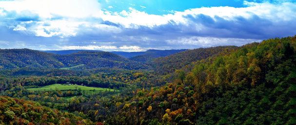
Allegany County lies primarily in the Ridge-and-Valley Country of the Appalachian Mountains. It is bordered to the north by the Mason–Dixon line with Pennsylvania, to the south by the Potomac River and West Virginia, to the east by Sideling Hill Creek and Washington County, Maryland, and to the west by a land border with Garrett County, Maryland. The western part of the county contains a portion of the steep Allegheny Front, which marks the transition to the higher-elevation Appalachian Plateau and Allegheny Mountain region. The town of Frostburg is located west of the Front at an elevation of nearly 2,100 feet above sea level, while the county seat of Cumberland, only eight miles away, has an elevation of only 627 feet.
National protected areas
Rail
Public transportation
2000 census
As of the census of 2000, there were 74,930 people, 29,322 households, and 18,883 families residing in the county. The population density was 176 people per square mile (68/km²). There were 32,984 housing units at an average density of 78 per square mile (30/km²). The racial makeup of the county was 93.02% White, 5.35% Black or African American, 0.15% Native American, 0.52% Asian, 0.03% Pacific Islander, 0.19% from other races, and 0.75% from two or more races. 0.76% of the population were Hispanic or Latino of any race. 29.0% were of German, 16.7% US or American, 12.8% Irish, 10.7% English and 5.3% Italian ancestry according to Census 2000.
There were 29,322 households out of which 26.50% had children under the age of 18 living with them, 50.60% were married couples living together, 10.30% had a female householder with no husband present, and 35.60% were non-families. 30.10% of all households were made up of individuals and 15.20% had someone living alone who was 65 years of age or older. The average household size was 2.35 and the average family size was 2.90.
In the county, the population was spread out with 20.60% under the age of 18, 11.20% from 18 to 24, 26.80% from 25 to 44, 23.50% from 45 to 64, and 17.90% who were 65 years of age or older. The median age was 39 years. For every 100 females there were 99.20 males. For every 100 females age 18 and over, there were 96.90 males.
The median income for a household in the county was $30,821, and the median income for a family was $39,886. Males had a median income of $31,316 versus $21,334 for females. The per capita income for the county was $16,780. About 9.70% of families and 14.80% of the population were below the poverty line, including 17.70% of those under age 18 and 9.50% of those age 65 or over.
As of 2010, Allegany County had a racial and ethnic population composition of 88.16% Non-Hispanic whites, 8.03% Blacks, 0.14% Native Americans, 0.76% Asians, 0.04% Pacific Islanders, 0.08% Non-Hispanics who reported some other race, 1.47% Non-Hispanics who reported two or more races and 1.44% Hispanics.
2010 census
As of the 2010 United States Census, there were 75,087 people, 29,177 households, and 17,959 families residing in the county. The population density was 177.0 inhabitants per square mile (68.3/km2). There were 33,311 housing units at an average density of 78.5 per square mile (30.3/km2). The racial makeup of the county was 89.2% white, 8.0% black or African American, 0.8% Asian, 0.1% American Indian, 0.2% from other races, and 1.6% from two or more races. Those of Hispanic or Latino origin made up 1.4% of the population. In terms of ancestry, 31.8% were German, 14.6% were Irish, 11.9% were English, 11.8% were American, and 5.6% were Italian.
Of the 29,177 households, 26.0% had children under the age of 18 living with them, 46.0% were married couples living together, 11.0% had a female householder with no husband present, 38.4% were non-families, and 31.6% of all households were made up of individuals. The average household size was 2.30 and the average family size was 2.86. The median age was 40.9 years.
The median income for a household in the county was $37,747 and the median income for a family was $52,680. Males had a median income of $42,322 versus $29,594 for females. The per capita income for the county was $20,764. About 9.6% of families and 14.5% of the population were below the poverty line, including 18.3% of those under age 18 and 8.8% of those age 65 or over.
Government and infrastructure
Allegany County was granted a home rule form of government in 1974. It is a strongly Republican county: the last Democrat to win a majority being Jimmy Carter in 1976.
The North Branch Correctional Institution, (opened 2003), and the earlier adjacent Western Correctional Institution are operated by the Division of Corrections of the Maryland Department of Public Safety and Correctional Services, (with its headquarters in Baltimore, Maryland) is located in an unincorporated area of Allegany County, just southwest of Cumberland. The prison housed male death row inmates, who were moved from the Maryland Correctional Adjustment Center, from June 2010 until death row was closed in 2014. County Government is governed by a 3-member board of County Commissioners
Education
Cities
Towns
Census-designated places
Occupying a middle ground between incorporated and unincorporated areas are Special Tax Districts, quasi-municipal unincorporated areas created by legislation passed by the Maryland General Assembly.[1] They lack home rule authority and must petition the General Assembly for changes affecting the authority of the district. There are eight Special Tax Districts in the county:
Other census-designated places in the county include: