
 | ||
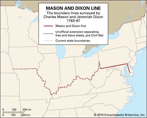
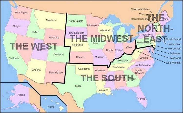
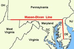
The Mason–Dixon line, also called the Mason and Dixon line or Mason's and Dixon's line, was surveyed between 1763 and 1767 by Charles Mason and Jeremiah Dixon in the resolution of a border dispute involving Maryland, Pennsylvania, and Delaware in Colonial America. It is still a demarcation line among four U.S. states, forming part of the borders of Pennsylvania, Maryland, Delaware, and West Virginia (originally part of Virginia).
Contents
- Background
- Geography of the line
- History
- Systematic errors and experiments to weigh the Earth
- Name
- Symbolism
- Books
- Film
- Cartoons
- Literature
- Music
- References
Background
Maryland's charter of 1632 granted the Calverts land North of the entire length of the Potomac River up to the 40th parallel. A problem arose when Charles II granted a charter for Pennsylvania in 1681. The grant defined Pennsylvania's Southern border as identical to Maryland's Northern border, but described it differently, as Charles relied on an inaccurate map. The terms of the grant clearly indicate that Charles II and William Penn believed the 40th parallel would intersect the Twelve-Mile Circle around New Castle, Delaware, when in fact it falls north of the original boundaries of the City of Philadelphia, the site of which Penn had already selected for his colony's capital city. Negotiations ensued after the problem was discovered in 1681. A compromise proposed by Charles II in 1682, which might have resolved the issue, was undermined by Penn receiving the additional grant of the "Three Lower Counties" along Delaware Bay, which later became the Delaware Colony, a satellite of Pennsylvania. Maryland considered these lands part of its original grant.
The conflict became more of an issue when settlement extended into the interior of the colonies. In 1732 the proprietary governor of Maryland, Charles Calvert, 5th Baron Baltimore, signed a provisional agreement with William Penn's sons, which drew a line somewhere in between and renounced the Calvert claim to Delaware. But later, Lord Baltimore claimed that the document he had signed did not contain the terms he had agreed to, and refused to put the agreement into effect. Beginning in the mid-1730s, violence erupted between settlers claiming various loyalties to Maryland and Pennsylvania. The border conflict would be known as Cresap's War.
Progress was made after a Court of Chancery ruling affirming the 1732 agreement, but the issue remained unresolved until Frederick Calvert, 6th Baron Baltimore ceased contesting the claims on the Maryland side and accepted the earlier agreements. Maryland's border with Delaware was to be based on the Transpeninsular Line and the Twelve-Mile Circle around New Castle. The Pennsylvania–Maryland border was defined as the line of latitude 15 miles (24 km) South of the southernmost house in Philadelphia (on what is today South Street). As part of the settlement, the Penns and Calverts commissioned the English team of Charles Mason and Jeremiah Dixon to survey the newly established boundaries between the Province of Pennsylvania, the Province of Maryland, and Delaware Colony.
In 1779, Pennsylvania and Virginia agreed "To extend Mason's and Dixon's line, due west, five degrees of longitude, to be computed from the river Delaware, for the southern boundary of Pennsylvania, and that a meridian, drawn from the western extremity thereof to the northern limit of the said state, be the western boundary of Pennsylvania for ever."
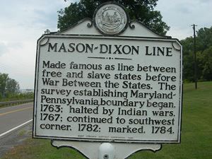
After Pennsylvania abolished slavery in 1781, the western part of this line and the Ohio River became a border between slave and free states, although Delaware retained slavery until the Thirteenth Amendment was ratified in 1865.
Geography of the line
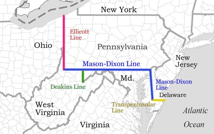
Mason's and Dixon's actual survey line began to the south of Philadelphia, Pennsylvania, and extended from a benchmark east to the Delaware River and west to what was then the boundary with western Virginia.
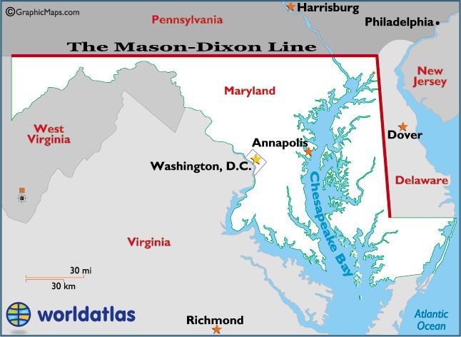
The surveyors also fixed the boundary between Delaware and Pennsylvania and the approximately north-south portion of the boundary between Delaware and Maryland. Most of the Delaware–Pennsylvania boundary is an arc, and the Delaware–Maryland boundary does not run truly north-south because it was intended to bisect the Delmarva Peninsula rather than follow a meridian.
The Maryland–Pennsylvania boundary is an east–west line with an approximate mean latitude of 39°43′20″ N (Datum WGS 84). In reality, the east–west Mason–Dixon line is not a true line in the geometric sense, but is instead a series of many adjoining line segments, following a path between latitude 39°43′15″ N and 39°43′23″ N.
The surveyors also extended the boundary line 40 miles (64 km) west of Maryland's western boundary, into territory that was still in dispute between Pennsylvania and Virginia, though this was contrary to their original charter. Mason's and Dixon's survey was finished on October 9, 1767, about 31 miles (50 km) east of what is now Pennsylvania's southwest corner.
In 1774 commissioners from Pennsylvania and Virginia met to negotiate their boundary, which at the time involved Pennsylvania's southern border west of Maryland and its entire western border. Both sides agreed that Pennsylvania's grant made its western border a tracing of the course of the Delaware River, displaced five degrees to the west. And both sides thought this would place Fort Pitt in Virginia territory (in fact it would not have). With that in mind the governor of Pennsylvania argued that despite the agreement reached with Maryland, Pennsylvania's southern border west of Maryland was still the 39th parallel, about 50 miles (80 km) south of the Mason–Dixon line. Negotiations continued for five years with a series of proposed lines. In the end a compromise was reached: the Mason–Dixon line would be extended west to a point five degrees west of the Delaware River. To compensate Pennsylvania for the claimed territory lost, its western boundary would be run due north rather than copying the course of the Delaware River.
The Mason–Dixon line was marked by stones every mile and "crownstones" every 5 miles (8.0 km), using stone shipped from England. The Maryland side says "(M)" and the Delaware and Pennsylvania sides say "(P)". Crownstones include the two coats-of-arms. Today, while a number of the original stones are missing or buried, many are still visible, resting on public land and protected by iron cages.
Mason and Dixon confirmed earlier survey work which delineated Delaware's southern boundary from the Atlantic Ocean to the "Middle Point" stone (along what is today known as the Transpeninsular Line). They proceeded nearly due north from this to the Pennsylvania border.
Later the line was marked in places by additional benchmarks and survey markers. The lines have been resurveyed several times over the centuries without substantive changes to Mason's and Dixon's work. The stones may be a few to a few hundred feet east or west of the point Mason and Dixon thought they were; in any event, the line drawn from stone to stone forms the legal boundary.
According to Dave Doyle at the National Geodetic Survey, part of the National Oceanic and Atmospheric Administration, the common corner of Pennsylvania, Maryland, and Delaware, at The Wedge is marked by Boundary Monument #87. The marker "MDP Corner" dates from 1935 and is offset on purpose.
Doyle said the Maryland–Pennsylvania Mason–Dixon line is exactly:
39°43′19.92216″ Nand Boundary Monument #87 is on that parallel, at:
075°47′18.93851″ W.Visitors to the tripoint are strongly encouraged to first obtain permission from the nearest landowner, or use the path from the arc corner monument which is bordered by Delaware parkland most of the way, and Pennsylvania parkland the entire way.
History
The line was established to end a boundary dispute between the British colonies of Maryland and Pennsylvania/Delaware. Maryland had been granted the territory north of the Potomac River up to the fortieth parallel. Pennsylvania's grant defined the colony's southern boundary as following a 12-mile (radius) circle (19 km) counter-clockwise from the Delaware River until it hit "the beginning of the fortieth degree of Northern latitude." From there the boundary was to follow the fortieth parallel due west for five degrees of longitude. But the fortieth parallel does not in fact intersect the 12-mile circle, instead lying significantly farther north. Thus Pennsylvania's southern boundary as defined in its charter was contradictory and unclear. The most serious problem was that the Maryland claim would put Philadelphia, the major city in Pennsylvania, within Maryland.
The dispute was peacefully resolved in 1767 when the boundary was fixed as follows:
The disputants engaged an expert British team, astronomer Charles Mason and surveyor Jeremiah Dixon, to survey what became known as the Mason–Dixon line. It cost the Calverts of Maryland and the Penns of Pennsylvania £3,512/9 s to have 244 miles (393 km) surveyed with such accuracy. To them the money was well spent, for in a new country there was no other way of establishing ownership.
The Mason–Dixon line is made up of four segments corresponding to the terms of the settlement:
The most difficult task was fixing the tangent line, as they had to confirm the accuracy of the transpeninsular line midpoint and the 12-mile circle, determine the tangent point along the circle, and then actually survey and monument the border. They then surveyed the north and arc lines. They did this work between 1763 and 1767. This actually left a small wedge of land in dispute between Delaware and Pennsylvania until 1921.
In April 1765, Mason and Dixon began their survey of the more famous Maryland–Pennsylvania line. They were commissioned to run it for a distance of five degrees of longitude west from the Delaware River, fixing the western boundary of Pennsylvania (see the entry for Yohogania County). However, in October 1767, at Dunkard Creek near Mount Morris, Pennsylvania, nearly 244 miles (393 km) west of the Delaware, their Iroquois guides refused to go any further, having reached the border of their lands with the Lenape, with whom they were engaged in hostilities. As such the group was forced to quit, and on October 11, they made their final observations, 233 miles (375 km) from their starting point.
In 1784, surveyors David Rittenhouse and Andrew Ellicott and their crew completed the survey of the Mason–Dixon line to the southwest corner of Pennsylvania, five degrees from the Delaware River. Other surveyors continued west to the Ohio River. The section of the line between the southwestern corner of Pennsylvania and the river is the county line between Marshall and Wetzel counties, West Virginia.
The Mason–Dixon line has been resurveyed three times: in 1849, 1900, and in the 1960s. On November 14, 1963, during the bicentennial of the Mason–Dixon line, U.S. President John F. Kennedy opened a newly completed section of Interstate 95 where it crossed the Maryland–Delaware border. It was one of his last public appearances before his assassination in Dallas, Texas. The Delaware Turnpike and the Maryland portion of the new road were later designated as the John F. Kennedy Memorial Highway.
Systematic errors and experiments to weigh the Earth
Mason and Dixon could only do the work as accurately as they did due to the work of Nevil Maskelyne, some of whose instruments they used. There was keen interest in their work and much communication between the surveyors, Maskelyne and other members of the British Scientific establishment in the Royal Society in Britain, notably Henry Cavendish. During such survey work it is normal to survey from point to point along the line and then survey back to the starting point, where if there were no errors the origin and re-surveyed position would coincide. Normally the return errors would be random – i.e. the return survey errors compared to the intermediate points back to the start point would be spatially randomly distributed around the start point. Mason and Dixon found that there were larger than expected systematic errors, i.e. non-random errors, that led the return survey consistently being in one direction away from the starting point. When this information got back to the Royal Society members, Henry Cavendish realised that this may have been due to the gravitational pull of the Allegheny Mountains deflecting the theodolite plumb-bobs and spirit levels. Maskelyne then proposed measuring the gravitational force causing this deflection induced by the pull of a nearby mountain upon a plumb-bob in 1772 and sent Mason (who had returned to England) on a site survey through central England and Scotland to find a suitable location during the summer of 1773. Mason selected Schiehallion at which to conduct what became known as the Schiehallion experiment, which was carried out primarily by Maskelyne and determined the density of the Scottish mountain. Several years later Cavendish used a very sensitive torsion balance to carry out the Cavendish experiment and determine the density of the Earth.
Name
Mason and Dixon likely never heard the phrase, "Mason-Dixon line". The official report on the survey, issued in 1768, did not even mention their names. While the term was used occasionally in the decades following the survey, it came into popular use when the Missouri Compromise named "Mason and Dixon's line" as part of the boundary between slave territory and free territory.
Symbolism
In popular usage, the Mason–Dixon line symbolizes a cultural boundary between the North and the South (Dixie). Originally "Mason and Dixon's Line" referred to the border between Pennsylvania and Maryland. After Pennsylvania abolished slavery, it served as a demarcation line for the legality of slavery. That demarcation did not extend beyond Pennsylvania because Delaware, then a slave state, extended north and east of the boundary. Also lying north and east of the boundary was New Jersey, where slavery was formally abolished in 1846, but former slaves continued to be "apprenticed" to their masters until the passage of the Thirteenth Amendment to the United States Constitution in 1865.
The Missouri Compromise line had a much clearer geographic connection to slavery in the United States leading up to the Civil War.
Books
In the novel People's Choice by Jeff Greenfield the character of W. Dixon Mason is an African-American preacher who plays a major role in determining the next U.S. President when the elected candidate dies between the popular election and the Electoral College formal vote.
Film
Cartoons
The line makes several appearances in the 1953 Bugs Bunny cartoon "Southern Fried Rabbit". The line separates the drought affected North from which the "Yankee" Bugs leaves in search of carrots in the green lands of the "Dixie" south. The latter being guarded by Yosemite Sam
Literature
Music
The title track of Mark Knopfler's second solo album, which features a duet with James Taylor , Sailing to Philadelphia (released 2000) is based on the journey of Jeremiah Dixon and Charles Mason to draw the Mason–Dixon line, with lyrics adapted from the novel Mason & Dixon by Thomas Pynchon.