
Elevation 2,037 m | ||
 | ||
Appalachian plateau
The Appalachian Plateau is a series of rugged, high plains located on the western side of the Appalachian Highlands. The Appalachian Highlands are a mountain range that run down the entire east coast of the United States. The Appalachian Plateau is the northwestern part of the Appalachian Mountains, stretching from New York to Alabama. The plateau is a second level United States physiographic region, covering parts of the states of New York, Pennsylvania, Ohio, Maryland, West Virginia, Virginia, Kentucky, Tennessee, Alabama, and Georgia.
Contents
- Appalachian plateau
- Geography and physiography
- Physiographic Regions
- Geology
- Native Americans
- European settlement
- Protected lands
- Plants
- Animals
- Landmarks and state parks
- References

Appalachian plateau
Geography and physiography
The formation of the plateau began during the Paleozoic Era. Regional uplift during this time caused the area to rise altogether without changing the topography of the land. The eastern side of the plateau appears as a mountain range. This false appearance is due to a very steep slope on the eastern side known as the Allegheny Front. The eastern edge is the highest part of the Appalachian Plateau. In Pennsylvania, the altitude ranges from 1,750 to 3,000 feet and continues to rise towards West Virginia, where the elevation is around 4,800 feet. From West Virginia to Tennessee the elevation lowers to 3,000 feet and continues slanting downward to 1,000 feet in Alabama. On the western side of the plateau, the elevation is 900 feet in Ohio, increasing to about 2,000 feet in Kentucky. From Kentucky the elevation drops down to 500 feet in northwestern Alabama. The plateau has a slight slant towards the northwest making it higher on the eastern side.
A large portion of the plateau is a coalfield that was formed approximately 320 million years ago during the Pennsylvanian Age. The plateau was subjected to glaciation during the Pleistocene ice age. As a result, the topography of this section of the plateau is relatively flat in comparison to the rest of the province. This portion of the plateau is marked with evidence of a glaciated past including bogs, lakes, and small hills of sand and gravel. The topography of the rest of the plateau was created mainly from stream erosion. The result is a rugged landscape, unlike many other plateaus, that includes many narrow stream valleys surrounded by steep ridges.
Physiographic Regions
A physiographic region is a large portion of land that is grouped together by several factors. Each region has similar geology, topography, and groups of plants and animals. There are eight physiographic regions in the United States. Each region is divided into provinces, there are 25 provinces in the United States. Each region is then divided into sections, creating 85 different physio-graphic sections in the United States. The Appalachian Plateau is a province of the physio-graphic region Appalachian Highlands. The Appalachian Plateau province is then broken down into seven physio-graphic sections: Mohawk, Catskill, Southern New York, Allegheny Mountains, Kanawha, Cumberland Plateau, and the Cumberland Mountains. Each section is classified under the Appalachian Plateau province because of its similarities in geologic makeup, topography, and wildlife. Likewise, the Appalachian Plateau falls under the classification of Appalachian Highlands because of those similar characteristics.
Geology
The rock underlying the Appalachian Plateau consists of a base of Precambrian rock, overlain by sedimentary rock from the Paleozoic Era. On top of the basement is a thick layer, approximately 20,000 feet, of a mixture of Cambrian, Ordovician, and Middle Silurian rock. This rock consists of shale, siltstone, and sandstone. Above this layer is the Upper Silurian evaporate basin, or basin of chemically formed sedimentary rocks. The Plateau fold belt consists of structurally complex Paleozoic strata which were thrust faulted over the younger evaporates.
When the Appalachian mountains were formed, the plateau was lifted. Ridges and valleys all die down underneath the plateau. There are multiple valleys throughout the region which consist of exposed areas of limestone and shale.
Native Americans
Archaeologists have evidence that Native Americans lived in the Appalachian region over twelve thousand years ago; however, it is hard to say exactly when the occupants first inhabited the land. In fact, human artifacts were collected by the Meadowcroft Rockshelter in southern Pennsylvania that were at least sixteen thousand years old. Considering the Native Americans were hunter-gatherers living off the land, they left little trace of human life behind them, which is why it is so hard to identify approximately when they arrived. Much like all Native Americans, the Appalachian inhabitants survived as nomads, following their food.
Around this period, North America was still recuperating from its last glacial period and the climate was much different than now. The climate more closely resembled a tundra, with lower temperatures, conifer trees and large mammals such as mammoths and saber-toothed tigers. Eventually, the climate began to warm up again, the large mammals started to disappear, and the vegetation seen more often today began to flourish. These climatic changes made life more sustainable for the Native Americans. They continued to invent new weapons and made advancements in agriculture until the Europeans arrived in North America.
European settlement
Europeans settled in North America in the seventeenth century, and in 1749, Jacob Martin and Steven Sewell first settled the Appalachian Plateau, specifically in what is now Pocahontas County in West Virginia. European settlement brought about many bloody battles, diseases, and death. Much of this land became farmland for the European settlers.
From 1861 to 1865, the Appalachian Plateau suffered from the Civil War, but in comparison to many other parts of the country, little damage was done. During the war, Union forces gained control over a majority of the plateau, and afterwards that possession was not challenged. Only three noteworthy battles occurred in the plateau region during the war, so not much of the land was destroyed.
After the war, the coal industry boomed. Many counties in the Appalachian Plateau region were dominated by coal mining, like McDowell County in West Virginia. Coal mining towns were created, and many immigrants moved in to work. Although good for the economy, many horrible disasters occurred, like the Monongah mining disaster of 1907.
Protected lands
Protecting the Appalachian Region from damage of human influence has been important in the modern era. Conservationists have been fighting to preserve the wildlife in the Appalachia region. The region has proved that with good care, the flora and fauna can be very resilient. However, back in 1890, the destruction of the Appalachian region's forest was at full-scale with the invention of the railroad, saw-mills, and clear-cutting of trees. This caused major flooding and wildfires to the region and destroyed keystone species across the region. Realizing that the destruction of the forest was becoming a major issue, the government passed the Weeks Act of 1911, which allowed the federal government to purchase private land in order to protect rivers and watersheds in the eastern United States.
The first purchase under this act was the Pisgah National forest. In 1964, the Wilderness Act expanded protections for millions of acres of federal land, such as the Shining Rock and Linville Gorge. The 1975 Eastern Wilderness Act created expanded protected areas in North Carolina, Virginia, and Tennessee. Today, close to 21% of the region is protected. Conservation groups that are dedicated to preserving the Appalachian Plateau region include the Southern Appalachian Forest Coalition and the Northern Forest Alliance. Ultimately, experts and researchers say the best way to continue protecting the Appalachian region is to incorporate conservation into public education so that people understand and support the benefits of conserving the lands.
Plants
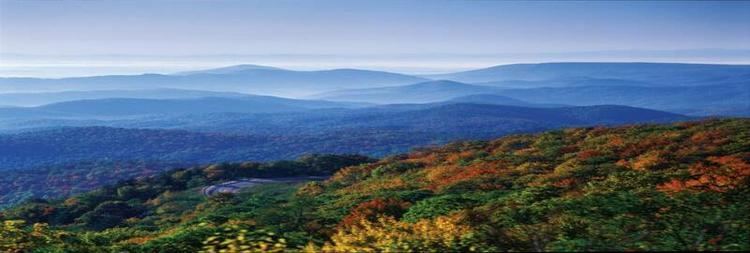
The Appalachian region is home to a wide variety of plant and animal life due to its vast array of climate and conditions giving the Appalachian Plateau region great biodiversity. To the north are many conifers, such as red spruce and balsam fir which can be seen growing at the northernmost latitudes of the Appalachian region. In the northern sections of the plateau at lower elevations you can find northern hardwoods, such as sugar maple and white oak. In southern Appalachia, growth of sycamore, walnut, and hickory trees are common. It is estimated that there is around 2,000 species of flora within the Appalachia region. Flowers vary due to elevation and climate of the area of Appalachia region. Different types of flowers in the northern and southern sections of the Appalachia. Flowers such as rhododendron, azalea and mountain laurel can be found in southern regions while up north trees will bear serviceberry, redbud, sourwood, and many others.
Animals
Fauna such as bison and wolves used to be native to the Appalachian region but have subsequently vanished. Elk still are present in some regions. Throughout all of the Appalachian Plateau region there is an abundance of fox, raccoon, wild boar, black bears, white-tailed deer, and beaver. Researchers also found there to be over 200 species of game and song birds including wild turkey, heron, geese, hawks, ducks and many more.
Fungi are also prominent in the Appalachia region. Abundant mushroom and lichen can be found including chanterelle, oyster mushroom and rock tripe.
Landmarks and state parks
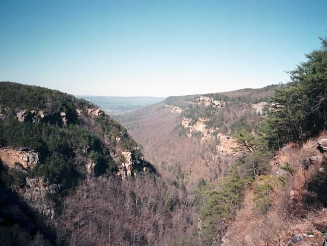
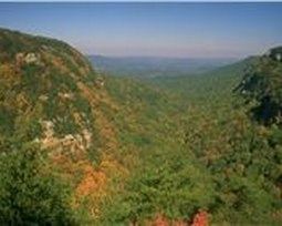
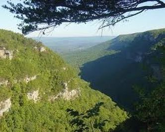
The Appalachian Plateau has many landmarks and public spaces to camp out, go hiking, and sight see. The Cloudland Canyon State Park is a prominent landmark in the Appalachian Plateau. At 3,485 acres, the Cloudland Canyon State Park is one of the largest and most scenic parks throughout the Appalachian Plateau. Its rugged geology offers a wide range of activities for tourists and campers to take part in. Spacious views of the canyon can be seen anywhere from the midst of the trail, to picnic tables at resting areas.
Another well-known landmark in the Appalachian Plateau is The Great Smoky Mountains. The Smoky Mountains are an estimated 187,000 acres and consist of old growth forests. The name “Smoky” comes from the natural fog that sometimes hangs over the mountain range and looks like a cloud of smoke from a distance. The Hocking Hills are deeply dissected in the Appalachian Plateau area. The hills themselves feature cliffs, gorges, waterfalls and even rock shelters. It is a very historic landmark and many tourists along with campers and hikers come to see the beauty and serenity of the hills. The hills are known to be thick, hard and weather resistant, which in turn builds deep gorges and very high cliffs.