
Length 523 km | Source elevation 759 m | |
 | ||
Main source Allegany Township, Potter County, near Coudersport, Pennsylvania at the corner of Ben Green and Cobb Hill Rd~2,490 ft (760 m) Basin size 11,580 sq mi (30,000 km) Tributaries Left:Tionesta Creek, Clarion River, Redbank Creek, Mahoning Creek, Crooked Creek, Kiskiminetas River, Buffalo Creek, Chartiers Run, Pucketa CreekRight:Conewango Creek, Brokenstraw Creek, Oil Creek, French Creek, Bull Creek, Deer Creek, Squaw Run, Pine Creek, Girtys Run Bridges Roberto Clemente Bridge, Fort Duquesne Bridge Islands Courson Island, Crull's Island, Jacks Island, Donley Island, Cogley Island | ||
The Allegheny River /ælᵻˈɡeɪni/ is a principal tributary of the Ohio River; it is located in the Eastern United States. The Allegheny River joins with the Monongahela River to form the Ohio River at the "Point" of Point State Park in Downtown Pittsburgh, Pennsylvania. The Allegheny River is, by volume, the main headstream of the Ohio River.
Contents
- Map of Allegheny River United States
- Fishing allegheny river near tidioute pennsylvania
- Geography
- Etymology
- Course
- Tributaries
- Navigation
- Flood control
- Crossings
- History
- References
Map of Allegheny River, United States
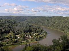
Fishing allegheny river near tidioute pennsylvania
Geography
The river is approximately 325 miles (523 km) long, running through the U.S. states of New York and Pennsylvania. It drains a rural dissected plateau of 11,580 square miles (30,000 km2) in the northern Allegheny Plateau, providing the northeastern most drainage in the watershed of the Mississippi River. Its tributaries reach to within 8 miles (13 km) of Lake Erie in southwestern New York.
The Allegheny Valley has been one of the most productive areas of fossil fuel extraction in U.S. history, with its extensive deposits of coal, petroleum, and natural gas.
Etymology
The name Allegheny probably comes from Lenape welhik hane or oolikhanna, which means 'best flowing river of the hills' or 'beautiful stream'. There is a Lenape legend of a tribe called "Allegewi" who used to live along the river.
The following account of the origin of the name Allegheny was given in 1780 by Moravian missionary David Zeisberger: "All this land and region, stretching as far as the creeks and waters that flow into the Alleghene the Delawares called Alligewinenk, which means 'a land into which they came from distant parts'. The river itself, however, is called Alligewi Sipo. The whites have made Alleghene out of this, the Six Nations calling the river the Ohio."
Indians, including the Lenni Lenape and Iroquois, considered the Allegheny and Ohio rivers as the same, as is suggested by a New York State road sign on Interstate 86 that refers to the Allegheny River also as Ohiːyo'. The Geographic Names Information System lists O-hee-yo and O-hi-o as variant names. The river is called Ohi:'i:o` (river beautiful) in the Seneca language. In New York, areas around the river are often named with the alternate spelling Allegany in reference to the river; for example, the Village of Allegany and Allegany State Park. Port Allegany, located along the river in Pennsylvania near the border with New York, also follows this pattern.
Course
The Allegheny River rises in north central Pennsylvania, on Cobb Hill in central Potter County, approximately 10 miles (16 km) south of the New York border. It flows west past Coudersport then turns north at Port Allegany and proceeds into western New York, looping westward across southern Cattaraugus County for approximately 30 miles (48 km), past Portville, Olean, St. Bonaventure University and Salamanca and flowing through Seneca Indian Nation lands close to the northern boundary of Allegany State Park before re-entering northwestern Pennsylvania approximately 20 miles (32 km) southeast of Jamestown, New York.
It flows in a broad zigzag course generally southward across Western Pennsylvania; first flowing southwest past Warren, Tidioute, Tionesta, Oil City, and Franklin, forming much of the northwestern boundary of Allegheny National Forest. South of Franklin it turns southeast across Clarion County in a meandering course, then turns again southwest across Armstrong County, flowing past Kittanning, Ford City, Clinton, and Freeport.
The river enters both Allegheny and Westmoreland counties, the Pittsburgh suburbs, and the City of Pittsburgh from the northeast. It passes Sligo, Karns, and Natrona in Harrison Township; Metcalf, Braeburn, Lower Burrell, and New Kensington; Brackenridge, Tarentum, Creighton, Clyde, Springdale, Harmarville, Blawnox, O'hara Township, Aspinwall, Sharpsburg, Etna, Millvale, Lawrenceville, Highland Park, the North Side, Downtown Pittsburgh, and Point State Park. The Allegheny joins with the Monongahela River at the "Point" in Downtown Pittsburgh, Pennsylvania to form the Ohio River.
Water from the Allegheny River eventually flows into the Gulf of Mexico via the Ohio and Mississippi rivers.
Tributaries
In its upper reaches, the Allegheny River is joined from the south by Potato Creek 1.7 miles (2.7 km) downstream of Coryville, Pennsylvania and from the north by Olean Creek at Olean, New York. Tunungwant "Tuna" Creek joins the river from the south in Carrollton, New York (flowing north from Bradford, Pennsylvania); the Great Valley Creek and Little Valley Creek join the river from the north at Salamanca, New York before becoming the Allegheny Reservoir.
After re-entering Pennsylvania, the river is joined from the east by Kinzua Creek 10 miles (16 km) upstream of Warren; from the north by Conewango Creek at Warren; from the west by Brokenstraw Creek; from the east by East Hickory Creek at East Hickory; from the east by Tionesta Creek at Tionesta; from the north by Oil Creek at Oil City; from the west by French Creek at Franklin; from the east by the Clarion River, a principal tributary, at Parker; from the east by Crooked Creek southeast of Kittanning; and from the east by the Kiskiminetas River, another principal tributary, at Schenley. Buffalo Creek enters at Freeport, Chartiers Run enters at Lower Burrell, Bull Creek enters at Tarentum, Pucketa Creek enters near New Kensington, Riddle Run enters at Springdale, and Girtys Run enters at Millvale. Many additional streams enter or join with the Allegheny River along its course.
Navigation
The Allegheny River has eight locks and dams (numbered two through nine), which form corresponding pools.
Flood control
The river is also impounded by the Kinzua Dam in northwestern Pennsylvania, resulting in the Allegheny Reservoir. The Seneca Pumped Storage Generating Station is associated with Kinzua Dam.
Crossings
Numerous bridges and tunnels span the river throughout its course. The Allegheny River Tunnel, utilized by Pittsburgh Light Rail, went into service in 2012.
History
In the 16th century, control of the river valley passed back-and-forth between Algonquian-speaking Shawnee and the Iroquois. By the time of the arrival of the French in the early 18th century, the Shawnee were once again in control and formed an alliance with the French against the incursion of British settlement across the Allegheny Mountains. The conflict over the expansion of British settlement into the Allegheny Valley and the surrounding Ohio Country was a primary cause of the French and Indian War in the 1750s. During the war, the village of Kittanning – the principal Shawnee settlement on the river – was completely destroyed by British reprisal raids from Central Pennsylvania.
Nevertheless, the British, after gaining control of the area in the 1763 Treaty of Paris, kept the area closed to white settlement, in part to repair and maintain relations with the Native Americans. The pressure to open the river valley and the surrounding area to settlement is considered by historians to be one of the root causes of the American Revolutionary War in the following decade. After the war, the entire river valley became part of the United States of America.
During the 19th century, the river became a principal means of navigation in the upper Ohio valley, especially for the transport of coal. Although the building of the railroads lessened the importance of the river somewhat, the lower river (navigable as far as East Brady, Pennsylvania through locks) has continued to serve as route of commercial transportation until the present day. In 1859, the first U.S. petroleum was drilled north of the river at Titusville.
One of the underlying premises of the Genesee Valley Canal was its connection to the river, opening a trade route from Rochester, New York to the west. The advent of the railroads destroyed any interest that Pennsylvania might have had in participating by improving navigation on the river.
In 1965, the completion of the federally sponsored Kinzua Dam for flood-control in northwestern Pennsylvania east of Warren created the long Allegheny Reservoir, part of which is included in the Allegheny National Recreation Area. The dam flooded parts of lands deeded "forever" to the Seneca Nation of Indians by the 1794 Treaty of Canandaigua, and to lands given to Cornplanter and his descendants. The event was described in the Johnny Cash song "As Long as the Grass Shall Grow" from the 1964 album Bitter Tears: Ballads of the American Indian, which focused on the history of and problems facing Native Americans in the United States.
The construction of the dam and the filling of the Allegheny Reservoir also necessitated the elimination of the small village of Corydon, which was located at the confluence of Willow Creek with the Allegheny River; and the small village of Kinzua, which was located at the confluence of Kinzua Creek with the Allegheny River. All residents of both villages were forced to move.
Many prominent individuals opposed the construction of the dam at that time because of the damage it would do to Seneca lands, including Pennsylvania Congressman John P. Saylor of Johnstown, and Howard Zahniser, executive director of The Wilderness Society and native of Tionesta—a small settlement located along the Allegheny River several miles downstream from Warren. During the campaign for the 1960 United States presidential election, John F. Kennedy assured the Seneca Nation that he would oppose the dam if elected. However, he failed to follow through on his pledge upon becoming president.
In 1992, 86.6 miles (139.4 km) of the Allegheny River was designated Wild and Scenic. This designation comprises three segments of the river located in Warren, Forest, and Venango counties.
In 2008, Katie Spotz became the first person to swim the entire 325 miles (523 km) of the Allegheny River; she was accompanied by safety kayaker, James Hendershott. The team began at the river's source in Raymond, Pennsylvania on July 22 and finished at the "Point" in Downtown Pittsburgh on August 21.