
Island Honshū ISO 3166 code JP-30 Area 4,726 km² | Area rank 30th Districts 6 Capital Wakayama | |
 | ||
Population 1.019 million (31 Mar 2012) Weather 17°C, Wind S at 21 km/h, 90% Humidity Points of interest Destinations | ||
Japan travel things to do explore and experience in wakayama prefecture 29
Wakayama Prefecture (和歌山県, Wakayama-ken) is a prefecture of Japan on the Kii Peninsula in the Kansai region on Honshū island. The capital is the city of Wakayama.
Contents
- Japan travel things to do explore and experience in wakayama prefecture 29
- Map of Wakayama Prefecture Japan
- 00 welcome to wakayama prefecture non japanese residents introduce the charms of kansai vol 2
- History
- 1953 flood disaster
- Cities
- Towns and villages
- Economy
- Demographics
- Culture
- Sister relationships
- Tourism
- Rail
- Expressway
- National Highway
- Ferry
- Airport
- Universities
- References
Map of Wakayama Prefecture, Japan
00 welcome to wakayama prefecture non japanese residents introduce the charms of kansai vol 2
History
Present-day Wakayama is mostly the western part of the province of Kii.
1953 flood disaster
On July 17–18, 1953, a torrential heavy rain occurred, followed by collapse of levees, river flooding and landslides in a wide area. Many bridges and houses were destroyed. According to an officially confirmed Japanese Government report, 1,015 people died, with 5,709 injured and 7,115 houses lost.
Cities
Nine cities are in Wakayama Prefecture:
Towns and villages
These are the towns and villages in each district:
Economy
Wakayama supplies most of Japan with its high production of mikans (Mandarin Oranges) in October.
Demographics
Wakayama is ranked 39th by population in Japan with a population of 989,983. It is the least populated prefecture in the Kansai region of Japan.
Its population is declining.
Culture
Mount Kōya (高野山, Kōya-san) in the Ito District is the headquarters of the Shingon sect of Japanese Buddhism. It is home to one of the first Japanese style Buddhist temples in Japan and remains a pilgrimage site and an increasingly popular tourist destination as people flock to see its ancient temples set amidst the towering cedar trees at the top of the mountain. The Sacred sites and pilgrimage routes in the Kii Mountain Range extend for miles throughout the prefecture and together have been recognized as Japan's 11th UNESCO World Heritage site.
The Kumano Shrines are on the southern tip of the prefecture. Tomogashima (a cluster of four islands) is part of the prefecture.
Sister relationships
Wakayama Prefecture has friendship and sister relationships with six places outside Japan: Richmond, Canada; Shandong, People's Republic of China; Pyrénées-Orientales, France; Florida, United States; Sinaloa, Mexico; and Galicia, Spain.
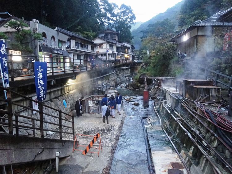
Tourism
Wakayama Prefecture has hot springs such as Shirahama, Kawayu, and Yunomine Onsen.