
Area 9,900 km² | ||
 | ||
The Kii Peninsula (紀伊半島, Kii Hantō) is the largest peninsula on the island of Honshū in Japan. It is named after the ancient Kii Province.
Contents
- Map of Kii Peninsula Dorogawa Tenkawa Yoshino District Nara Prefecture 638 0431 Japan
- LocationEdit
- Notable placesEdit
- TransportationEdit
- References
Map of Kii Peninsula, Dorogawa, Tenkawa, Yoshino District, Nara Prefecture 638-0431, Japan
The area south of the “Central Tectonic Line” is called Nanki (南紀), and includes the most poleward living coral reefs in the world due to the presence of the warm Kuroshio Current, though these are threatened by global warming and human interference. Because of the Kuroshio’s strong influence, the climate of Nankii is the wettest in the Earth’s subtropics with rainfall in the southern mountains believed to reach 5 metres (200 in) per year and in the southeastern town of Owase it averages 3.85 metres (151.6 in), comparable to Ketchikan, Alaska or Tortel in southern Chile. When typhoons hit Japan the Kii Peninsula is typically the worst affected area and daily rainfalls as high as 940 millimetres (37 in) are not unknown.
Most of the Kii Peninsula is dense temperate rainforest since the climate even in the very limited lowlands is too wet for agriculture, and much of the coast consists of networks of small rias into which flow very steep and rapid streams characterised by a large number of high waterfalls. Forestry and fishing were the traditional economic mainstays of the region and remain important even today despite a declining population and labour force.
LocationEdit
Wakayama Prefecture occupies much of the area, including the entire southern part. To the northwest of Wakayama Prefecture is Osaka Prefecture, whose southern part is on the peninsula. East of Osaka Prefecture is landlocked Nara Prefecture; farther east is Mie Prefecture.
The Seto Inland Sea lies to the west of the Kii Peninsula. To the south and east is the Pacific Ocean and to the north is the valley of the Kiso Three Rivers and Ise Bay.
Notable placesEdit
Notable places in the Kii Peninsula include :
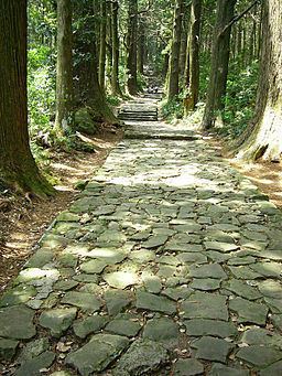
The Kii Peninsula is the location of a UNESCO World Heritage Site: Sacred Sites and Pilgrimage Routes in the Kii Mountain Range.
In 2004, UNESCO designated three other locations on the Kii Peninsula as World Heritage Sites. They are:
- Yoshino and Mount Omine, mountainous areas in the north of the peninsula.
- Kumano Shrines, three shrines at the southern tip of the peninsula.
- Mount Koya, the mountain at the west of the peninsula