
Population 20,618 (2006) | District Higashimuro Local time Sunday 4:27 PM | |
 | ||
Time zone Japan Standard Time (UTC+9) Weather 16°C, Wind NW at 11 km/h, 56% Humidity Points of interest Kushimotokaichū Park, Shionomisaki Lighthouse, Kashinozaki Lighthouse, Kushimoto Turkish Memorial, Muryō‑ji Temple | ||
Kushimoto (串本町, Kushimoto-chō) is a coastal town located in Higashimuro District, Wakayama Prefecture in western Japan. The town has the distinction of being the southernmost point of Japan's main island, Honshū. The central area of town is on a narrow isthmus, surrounded on both sides by the Pacific Ocean. Kushimoto is bordered by the towns of Susami on the west, Kozagawa on the north, and Nachi-Katsuura on the east.
Contents
- Map of Kushimoto Higashimuro District Wakayama Prefecture Japan
- History
- Name origin
- Climate
- Demographics
- Central
- Western
- Eastern
- Southern
- High schools
- Junior high schools
- Elementary schools
- Kindergartens
- Sites of interest
- Water sports
- Annual events and festivals
- Mass public transportation
- Private motoring
- Air and sea
- Friend cities
- References
Map of Kushimoto, Higashimuro District, Wakayama Prefecture, Japan
On April 1, 2005 Kushimoto absorbed the town of Koza, from Higashimuro District, to become the new town of Kushimoto.
The former town of Kushimoto was part of Nishimuro District, but the town has strong ties with the city of Shingū and Higashimuro District, both for political and economic reasons. The town became part of Higashimuro District upon this merger.
History
Though people were known to have inhabited the area since the Asuka Period, the first known documented settlements were established during the Edo Period. During that time, most of the area that encompasses Wakayama Prefecture today was known as Kii-no-Kuni (Kii Province) or Kishū. The area was owned by the Kii branch of the Tokugawa clan, headquartered at Wakayama Castle.
Kushimoto did not experience significant growth until the 20th century. It was officially incorporated into a town in Nishimuro District in 1907. Over the next decades, the town grew as a result of numerous mergers with the surrounding neighborhoods:
Being in a very strategic location, Kushimoto was home to many military installations during World War II, including the Kushimoto Seaplane Base and Shiono-Misaki Airfield. Both bases were attacked by the United States Navy and Air Force in 1945, including a naval bombardment on the night of 24/25 July. Shiono-Misaki Airfield now serves as a small base for the Japanese Air Self-Defense Force.
Kushimoto (or specifically, Shiono-Misaki) was the epicenter of the Great Nankai earthquake, a magnitude 8.0 earthquake that struck the area on December 21, 1946 at 4:19am. This triggered a tsunami that enveloped the central part of town. Most of the Fuji-Bashi neighborhood was destroyed but has since been rebuilt. There are memorials around town marking the event, including signposts indicating how far the tsunami had penetrated inland. Of the 269 casualties in Wakayama Prefecture, the majority were in Kushimoto and in the city of Kainan.
Name origin
There are two widely accepted views of where the name "Kushimoto" comes from. The first is explained by a strange tree growing in a shrine in Shiono-Misaki, whose seedling is thought to have floated from a far off island to its current resting place. An archaic compound form of the Chinese character for "kushi" (串) is said to have meant "strange tree"; in combination with the second character "moto" (本), the name is supposed to represent "strange tree's origin." Another explanation dictates that the "kushi" character is a visual abstraction of the town's layout; Shiono-Misaki and Oshima act as the smaller upper "kuchi" (口) radical, while the mainland acts as the larger lower one. The "bo" (|) radical that strikes through both of the others is said to represent the isthmus that runs through the town.
Climate
Owing to its location on the Kii Peninsula in the path of typhoons and the moist winds of the Kuroshio Current, Kushimoto has a very wet climate, receiving an average of 2,600 millimetres (102 in) of rainfall per year, though it is not quite as wet as Owase further east. The wettest month was September 1929 with 846.5 millimetres (33.3 in) whilst in January 2010 the town received no rain for the second time since records began in 1913 and had the lowest monthly humidity on record at 47 percent. The heaviest daily rainfall was 420.7 millimetres (16.6 in) on 17 October 1939. The data below are for Shionomisaki Lighthouse near the town.
Demographics
The population of Kushimoto is 20,618, consisting of 9,561 men and 11,057 women. There are a total of 9,397 families.
Central
Western
Eastern
Southern
High schools
Junior high schools
Elementary schools
Kindergartens
Sites of interest
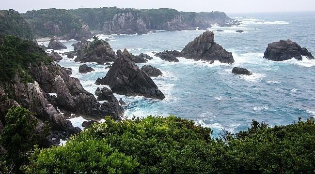
Kushimoto is famous for its many coastal rock formations, including Hashigui-Iwa and Umikongo. The cape of Shiono-Misaki, located in the southern tip of the town, has a park and tower marking the southernmost point of Honshū.
The island of Oshima, connected to the main town via the Kushimoto Big Bridge, is home to two museums of foreign origin.
Water sports
The surrounding wetlands and coastal areas in Kushimoto are designated areas of conservation through the Ramsar Convention of 1971. They have since become popular spots for scuba diving, with numerous diving establishments along National Highway 42.
A merger in 2004 incorporated the former town of Koza into Kushimoto. Located in the east of Kushimoto, Koza is home to the Kozagawa River. The river, regulated by the Shichikawa Dam, is one of three rivers in southern Wakayama Prefecture known for kayaking.
Though waves are relatively tame compared with worldwide standards, Kushimoto is a popular surfing spot for locals and people from the bigger cities in the Kansai area.
Annual events and festivals
In late January or early February is the Shiono-Misaki Fire Festival. During this event, the large grassy field that designates Honshū's southernmost tip is ritually burned. Spectators may walk through the fire as it progresses through the field.
In February is the Oshima Boat Race. Festivals grounds are set up at Oshima Port, and two boats ritually race to and from the port on the mainland Kushimoto.
In August, the Summer Fireworks Festival takes place at Kushimoto Port.
In October is the Sunset Marathon. The marathon's route winds through Oshima and Shiono-Misaki.
Mass public transportation
Rail service is provided by the West Japan Railway Company, or JR West, on the Kisei Line. There are direct services to other big cities in the Kansai area, with many limited express trains bound for Shin-Osaka Station and Kyoto Station. There are eight train stations in town (from west to east): Wabuka, Tako, Tanami, Kii-Arita, Kushimoto, Kii-Hime, Koza, and Kii-Tahara.
Local bus service is provided by the Kumano Bus Company. The nearest long distance bus services are located in Tanabe (for Osaka) and Nachi-Katsuura (for Tokyo).
Private motoring
National Highways 42 and 371 run through Kushimoto. The Hanwa Expressway, still under construction, is set to pass to the north of the town.
Air and sea
The nearest international airport is Kansai Airport. Nanki-Shirahama Airport, located in nearby Shirahama, is a smaller airport offering daily flights to Tokyo.
The nearest domestic ferry services are in Nachi-Katsuura.
Friend cities
Kushimoto has three sister cities: