
Population 17,261 (1 Feb 2012) | District Higashimuro Local time Monday 5:42 AM | |
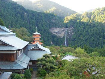 | ||
Time zone Japan Standard Time (UTC+9) City hall address Oji Tsukiji 7-1-1, Nachi-Katsuura Town, Nishimuro District, Wakayama Prefecture (和歌山県西牟婁郡那智勝浦町大字築地7丁目1番1号)649-53921 Weather 7°C, Wind N at 6 km/h, 77% Humidity Points of interest Nachi Falls, Seiganto‑ji, Fudarakusan‑ji, Kumano Nachi Taisha, 熊野古道大門坂 Daimon‑zaka | ||
Nachikatsuura (那智勝浦町, Nachikatsuura-chō) is a town located in Higashimuro District, Wakayama Prefecture, Japan.
Map of Nachikatsuura, Higashimuro District, Wakayama Prefecture, Japan
As of February 1, 2012, the town has an estimated population of 17,261, with 8,359 households, and a density of 94.09 persons per km². The total area is 183.45 km².
Created in 1955 from four towns: Nachi, Katsuura, Ukuimura and Wakamura, by 1960 the municipality expanded to include Shimosato farther south and Otamura inland up the Ota River.
The Kumano Nachi Taisha, one of the three Kumano Shrines, is in Nachi Katsuura. These shrines form part of the "Sacred Sites and Pilgrimage Routes in the Kii Mountain Range" UNESCO World Heritage Site.
References
Nachikatsuura Wikipedia(Text) CC BY-SA