 | ||
The polar front antarctic convergence lecture on ocean diamond
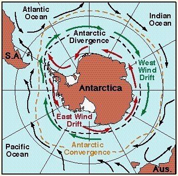
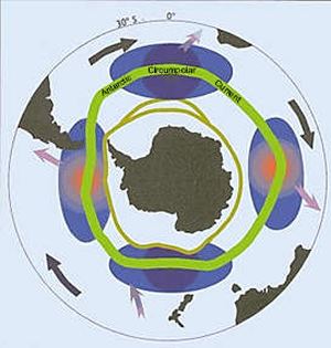
The Antarctic Convergence is a curve continuously encircling Antarctica, varying in latitude seasonally, where cold, northward-flowing Antarctic waters meet the relatively warmer waters of the subantarctic. Antarctic waters predominantly sink beneath subantarctic waters, while associated zones of mixing and upwelling create a zone very high in marine productivity, especially for Antarctic krill. This line, like the Arctic tree line, is a natural boundary rather than an artificial one like a line of latitude. It not only separates two hydrological regions, but also separates areas of distinctive marine life associations and of different climates. There is no Arctic equivalent, due to the amount of land surrounding the northern polar region.
Contents
- The polar front antarctic convergence lecture on ocean diamond
- Vlog 10 gary antarctic convergence
- History
- Location
- Places next north of the Convergence
- Places next south of the Convergence
- References
Vlog 10 gary antarctic convergence
History
The Antarctic Convergence was first crossed by Anthony de la Roché in 1675, and described by Sir Edmund Halley in 1700.
Location
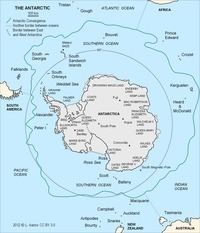
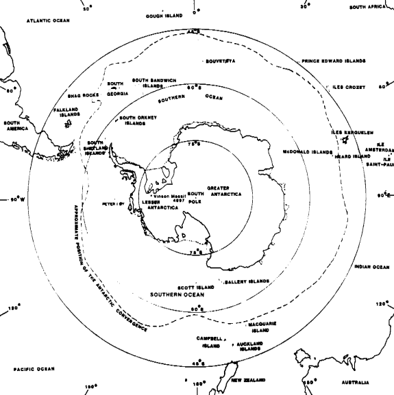
The Antarctic Convergence is a zone approximately 32 to 48 km (20 to 30 mi) wide, varying in latitude seasonally and in different longitudes, extending across the Atlantic, Pacific, and Indian Oceans between the 48th and 61st parallels of south latitude. Although the northern boundary varies, for the purposes of the Convention on the Conservation of Antarctic Marine Living Resources 1980, it is defined as "50°S, 0°; 50°S, 30°E; 45°S, 30°E; 45°S, 80°E; 55°S, 80°E; 55°S, 150°E; 60°S, 150°E; 60°S, 50°W; 50°S, 50°W; 50°S, 0°." Although this zone is a mobile one, it usually does not stray more than half a degree of latitude from its mean position. The precise location at any given place and time is made evident by the sudden drop in sea water temperature from north to south of, on average, 2.8 °C (5.0 °F) from 5.6 °C (42.1 °F) to below 2 °C (36 °F).
Places next north of the Convergence
Places next south of the Convergence
The Kerguelen Islands lie approximately on the Convergence.