
Length 24 km (14.9 mi) Highest elevation 625 m (2,051 ft) Area 142.7 km² | Width 5.23 km (3.25 mi) Peak Momchil Peak | |
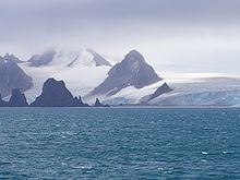 | ||
Greenwich Island (variant historical names Sartorius Island, Berezina Island) is an island 24 km (15 mi) long and from 0.80 to 9.66 km (0.5 to 6 mi) (average 5.23 km or 3.25 mi) wide, lying between Robert Island and Livingston Island in the South Shetland Islands. Surface area 142.7 square kilometres (55.1 sq mi). The name Greenwich Island dates back to at least 1821 and is now established in international usage.
Contents
Map of Greenwich Island, Antarctica
The Chilean base Arturo Prat and the Ecuadorian base Pedro Vicente Maldonado are situated on the northeast and north coast of the island respectively.
Map
References
Greenwich Island Wikipedia(Text) CC BY-SA