
Existed: 1927 – present Length 240.2 km | Constructed 1927 | |
 | ||
Counties Columbia County, Pennsylvania | ||
Pennsylvania route 44
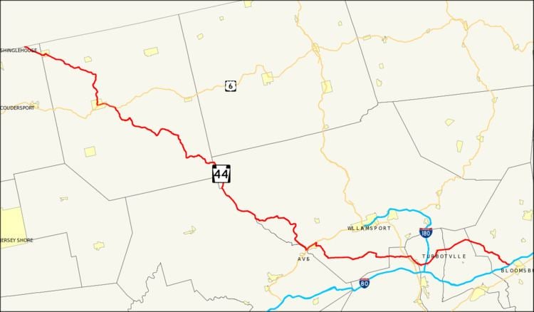
Pennsylvania Route 44 (PA 44) is a 149.24 mi (240.18 km)-long state highway in the U.S. state of Pennsylvania. The route is designated from Interstate 80 and Pennsylvania Route 42 in Buckhorn to the New York state line near New York State Route 417 in Ceres Township.
Contents
- Pennsylvania route 44
- Map of PA 44 Pennsylvania USA
- Columbia and Montour Counties
- Northumberland and Union Counties
- Clinton and Lycoming Counties
- Potter and McKean Counties
- History
- References
Map of PA-44, Pennsylvania, USA
Commissioned in 1927 by the Pennsylvania Department of Highways, PA 44 originally ran from the NY state line to Jersey Shore. Today, the highway is a scenic route from Columbia County to Potter County.
Columbia and Montour Counties
PA 44 begins in the census-designated place of Buckhorn at an intersection with Pennsylvania Route 42 and exit 232 of Interstate 80. From there, the highway runs northwest as Buckhorn Road through the Appalachians. In Jerseytown, the route intersects Pennsylvania Route 642 and Pennsylvania Route 254. Outside of Jerseytown, PA 44 turns westward as White Hall Road.
The route enters Montour County passing through the Muncy Hills. From Schuyler to Turbotville, Route 44 is concurrent with Pennsylvania Route 54 at Continental Boulevard.
Northumberland and Union Counties
PA 44 enters Northumberland County running southwest through the mainly plain and agricultural sections of the county. In the village of Mcewensville briefly east of the Interstate 180 underpass, the route intersects Main Street, the historic Susquehanna Trail that was once U.S. Route 111. From Watsontown to Dewart, PA 44 is concurrent with PA 405 along Main Street. In Dewart, the route turns west and crosses the West Branch Susquehanna River via Bridge Avenue; this is the former location of the historic Allenwood River Bridge, which was replaced by the current concrete structure in 1990.
West of the bridge, PA 44 is designated as a scenic route to the intersection with PA 144 in Potter County. After crossing the bridge, the route intersects U.S. Route 15 in the Union County community of Allenwood. West of the hamlet, PA 44 runs mainly west along the banks of the White Deer Hole Creek in the White Deer Valley.
Clinton and Lycoming Counties
The highway enters Lycoming County in the White Deer Valley area. In the hamlet of Washington at the intersection with Gap Road, PA 44 turns north before intersecting the southern terminus of PA 554 in Elimsport; on the intersection, the highway turns west.
West of Elimsport, the highway crosses the North White Deer Ridge; one of the ridges on the Appalachian Mountain system. West of the ridge, PA 44 intersects the southern terminus of PA 654 in the town of Collomsville. The route proceeds west and upon reaching a gap that cuts through the Bald Eagle Mountain range near the intersection with PA 880, the highway turns north.
North of the gap, the highway turns west and crosses the West Branch Susquehanna River and enters the borough of Jersey Shore. Inside the borough, PA 44 turns north onto Main Street for a short distance and interchanges the U.S. Route 220 expressway to begin a short 3 mile (5 km) wrong-way concurrency.
The expressway runs mainly southwest, officially signed as the "Frank D. Oreilly Highway". Southwest of the Pine Creek crossing, PA 44 leaves US 220. PA 44 crosses the creek again and continues north along the western banks of the creek.
In the village of Tomb, PA 44 intersects the western endpoint of PA 973, where the highway runs through the Pine Creek Gorge. Near the village of Cummings, PA 44 turns west to cross the Pine Creek and intersect PA 414. The highway proceeds west through the southern sections of the Tiadaghton State Forest. Through the reminder of the Lycoming section of PA 44, the highway runs north, serving primarily as the boundary between Lycoming and Clinton Counties.
Potter and McKean Counties
PA 44 enters Potter County through the western portions of the Tioga State Forest. At the eastern tip of the Susquehannock State Forest, PA 44 begins a concurrency with PA 144; the scenic route continues south, on PA 144. The two routes run briefly on Pine Hill Road. North of the overlap, PA 44 proceeds northwest through more mountainous terrain. This section of PA 44, signed as Cherry Springs Road, traverses many hills and mountains including Mount Brodhead, Cherry Springs Vista, Kaple Hill, and Cochran Hill.
North of the mountainous region, PA 44 turns west to begin a concurrency with U.S. Route 6, the Grand Army of the Republic Highway. The two routes run into the borough of Coudersport, where they split in downtown; US 6 turns south and PA 44 turns north onto Main Street. North of Coudersport, PA 44 meets the western terminus of PA 49.
The route proceeds northward into the Greenman Hill area. In Coneville, PA 44 intersects the western terminus of PA 244. From PA 244, the highway proceeds on a northwest direction into the northern tier of Pennsylvania. The highway spends over 55 miles in Potter County. The highway briefly enters McKean County for about a little over 3 miles, passing through its northeast corner (5 km) before terminating at the New York-Pennsylvania border and becoming a short road (less than 100 yards) that connects to New York State Route 417.
History
When PA 44 was commissioned in 1927, the route was designated from U.S. Route 220 in Jersey Shore to the New York-Pennsylvania border. Northeast of Coudersport from PA 49 to PA 244, and from US 6 to US 220, the road was not paved. From Jersey Shore to Turbotville, PA 44 was assigned the Pennsylvania Route 54 designation. From Turbotville to Jerseytown, the road was designated as Pennsylvania Route 454. From Jerseytown to Buckhorn, 44 was numbered as Pennsylvania Route 342.
By 1940, PA 44 was extended east to Turbotville, replacing the previous PA 54 alignment. Also in the 1940s, PA 44 was completely paved from Coudersport to the New York state line. In the 1950s, PA 44 was largely extended to Mahanoy City in Schuylkill County.
By 1970, the road was truncated to its current southern terminus in Buckhorn.