
Existed: 1928 – present Constructed 1928 | Length 23.66 km | |
 | ||
Counties | ||
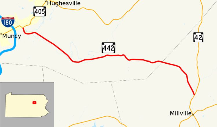
Pennsylvania Route 442 (designated by the Pennsylvania Department of Transportation as PA 442) is a 14.7-mile-long (23.7 km) state highway located in Lycoming and Columbia Counties in Pennsylvania. The western terminus is at Route 405 in Muncy. The eastern terminus is at Route 42 in Iola.
Contents
Map of PA-442, Muncy, PA, USA
Route description
Route 442 begins at a T-intersection with Pennsylvania Route 405 and East Penn Street in the borough of Muncy, Pennsylvania. Route 442 proceeds to the southeast from Route 405, passing through a mix of residences and fields, before entering Muncy Creek Township, where it passes a park. At about that point, Route 442 makes a gradual bend to the east and passes more residences before a turn to the southeast, where it enters Clarkstown. At the edge of Clarkstown, the highway passes some large industry and soon into a long stretch of residences before leaving after the intersection with Turkey Bottom Road. Route 442 continues southeastward for a while, passing a slew of residences and fields before entering dense woods near the intersection with Rock Road. At that point, the highway makes another gradual bend, curving to the northeast, and soon east into Moreland Township. The stretch through Moreland Township is rural, with Route 442 passing through a mix of fields and woods. After the intersection with P Houseknecht Road, the highway returns to its windy nature and bends to the southeast, and soon eastward once again. After starting another stretch eastbound, Route 442 leaves Moreland Township for Franklin Township, where the highway passes south of the community of Chestnut Grove, a small stretch of houses north of Route 442. After crossing south of Chestnut Grove, Route 442 crosses the county line into Columbia County.
Upon entering Columbia County, Pennsylvania Route 42 is immediately in Pine Township's local community of Pine Summit, a small stretch of houses north and south of the highway. The highway continues onto another elongated bend to the southeast, into the dense woods of Pine Township. This southeastern descent turns into a southward one after Shingle Run Road, where the dense woods begin to break up once again. Route 442 curves to the southeast once again, entering the outskirts of Iola, where the highway intersects with Pennsylvania Route 42. This intersection serves as Route 442's eastern terminus.