
Founded March 1, 1811 Largest city Pottsville Time zone Eastern: UTC-5/-4 Population 146,920 (2013) Unemployment rate 5.7% (Apr 2015) | Named for Schuylkill River Congressional district 17th Area 2,028 km² County seat Pottsville | |
 | ||
Website www.co.schuylkill.pa.us Destinations Kline Township, Pottsville, Schuylkill Haven Points of interest Locust Lake State Park, Vraj Hindu Temple, Pocono Mountains, Pioneer Tunnel Coal Mine, Tuscarora State Park Colleges and Universities Penn State Schuylkill, Schuylkill Technology Center, McCann School of Business | ||
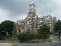
Haunted rest haven schuylkill county pennsylvania
Schuylkill County (pronounced /ˈskuːlkɪl/, locally /ˈskuːkəl/) is a county in the Commonwealth of Pennsylvania. As of the 2010 census, the population was 148,289. The county seat is Pottsville. The county was created on March 1, 1811, from parts of Berks, Northampton, and Northumberland counties and named for the Schuylkill River.
Contents
- Haunted rest haven schuylkill county pennsylvania
- Map of Schuylkill County PA USA
- 18th century
- 19th century
- 20th century
- Railroad history
- Geography
- Adjacent counties
- Major highways
- Demographics
- Micropolitan Statistical Area
- Law and government
- Commissioners
- Other county officials
- State Representatives
- State Senator
- US Representative
- Colleges and universities
- Public School Districts
- Communities
- City
- Census designated places
- Population ranking
- Notable people
- References
Map of Schuylkill County, PA, USA
Schuylkill County comprises the Pottsville, PA Micropolitan Statistical Area. It is located in the heart of the anthracite Coal Region of Eastern Pennsylvania.
18th century
In the year 1754, the area that would become Schuylkill County was settled by Germans, as were areas that are now part of Berks, Dauphin, Lebanon, and Lehigh counties. The earliest settlers in southeastern Schuylkill County, which was then part of Northampton County, were primarily Moravian missionaries from Saxony. Other early settlers in southern Schuylkill County were German Palatines. An early mill in the county was built in 1744 by John Finscher, but it later burned down. The first log church in the county was built in 1755. Native American massacres were commonplace in Schuylkill County between 1755 and 1765. Warrant for tracts of land in the vicinity of McKeansburg were in existence as early as 1750.
19th century
Schuylkill County was created via an Act of Assembly on March 1, 1811, from portions of Berks, Lancaster, and Northampton counties. More land was added to the county in 1818, from Columbia and Lehigh counties. An early book of Schuylkill County history was written by Daniel Deibert in 1802.
McKeansburg was the first community in Schuylkill County to be laid out. Initial construction of the community was done in 1803, and the community was expanded in 1809. During the early years of Schuylkill County, there was an attempt to make McKeansburg the county seat of the new county. The community of Orwigsburg was also a contender for the county seat. Orwigsburg was agreed upon to be the county seat, as it was deemed to be well-suited for industries.
20th century
Kelayres Massacre On November 5, 1934 Election Eve, there was a "parade" that marched through the Village of Kelayres, Kline Township. The "parade" consisted of a crowd of Democratic Party supporters, that marched toward the home of Republican Party leader, Joseph Bruno. Shots were fired as the crowd assembled in front and to the side of the home on Fourth & Centre Streets. Eventually several people were shot and killed and over 20 injured. Trials lasted for 2 years, convicting several Bruno Family members, who were eventually pardoned.
Railroad history
The Reading and Pennsylvania railroads: In the early 19th century southern Schuylkill County was served by the Union Canal out of Pine Grove Township with connections west, and the Schuylkill Canal southward from Port Carbon. Coal mined by Lehigh Coal and Navigation in the Tamaqua and Coaldale areas was often shipped down the Lehigh Canal from Jim Thorpe in neighboring Carbon County. To the north, Broad Mountain was a natural barrier to navigation. Other means would be required to transport coal out of the rich basin of the Mahanoy Valley. Numerous railroads were begun north of the headwaters of the Schuylkill Canal.
Through the 1830s and 1840s, short railroads sprouted up at numerous areas in the county. Of prime importance was the Mine Hill and Schuylkill Haven, which served the Schuylkill Canal. Chartered in 1831, tracks were laid from the "flats" in Schuylkill Haven along the river through Cressona and Minersville to Tremont. The railroad eventually reached Ashland and Locust Gap via the Gordon Planes.
Construction beginning in 1829, the Little Schuylkill Railroad ran from Port Clinton northward to Mahanoy Junction above Tamaqua. It would become the keystone of the Philadelphia and Reading system, serving as a gauntlet for its eastern and western branches. Connecting with it were four important lines. The 146 mile (235 km) Catawissa Railroad operated from Mahanoy Junction to West Milton, providing access to the Mahanoy region by joining the northern terminus of the Little Schuylkill with connections to New York City and Scranton. At Port Clinton, it connected with the P&R's main line from Mount Carbon. Its most important connection would be with the Mahanoy and Broad Mountain Railway via Mahanoy Tunnel and East Mahanoy Railroad.
There was once over 1,000 miles (1600 km) of railroad track in Schuylkill County.
Geography
According to the U.S. Census Bureau, the county has a total area of 783 square miles (2,030 km2), of which 779 square miles (2,020 km2) is land and 4.2 square miles (11 km2) (0.5%) is water.
The Schuylkill River headwaters are found in the county, starting in the Appalachian Mountains, and flows through many towns and the city of Reading, Pennsylvania to Philadelphia where it flows into the Delaware River. The Schuylkill drains the majority of the county while some western and northern areas of the county are drained by the Susquehanna River. The Swatara Creek, Wiconisco Creek, Mahantango Creek, Mahanoy Creek, and Catawissa Creek all start in Schuylkill County and are tributaries of the Susquehanna. Areas of the eastern portion of the county drain into the Lehigh River via the Quakake Creek, Nesquehoning Creek, Mahoning Creek, and Lizard Creek, all of which also start in the county. To the south, southern Schuylkill county is home to Blue Mountain and the Appalachian Trail. Broad Mountain crosses the county from northeast to southwest.
Schuylkill County is located in northeastern Pennsylvania's Coal Region. It is located just north of the Lehigh Valley and Reading metropolitan areas. Portions of eastern Schuylkill County around Tamaqua are located in the Pocono Mountains. As a result, like other portions of the Poconos, eastern Schuylkill has experienced an influx of people from New York City and New Jersey who commute into Manhattan each day. The commute can take up to two hours each way due to distance and traffic. Far western areas of the county are located near Harrisburg and are sometimes considered to be located in South Central Pennsylvania.
Adjacent counties
Major highways
Demographics
As of the census of 2000, there were 150,336 people, 60,530 households, and 40,131 families residing in the county. The population density was 193 people per square mile (75/km²). There were 67,806 housing units at an average density of 87 per square mile (34/km²). The racial makeup of the county was 96.62% White, 0.08% Native American, 0.42% Asian, 0.01% Pacific Islander, 0.35% from other races, 2.09% African American, and 0.43% from two or more races. Hispanic or Latino of any race were 1.11% of the population. 29.0% were of German, 14.1% Irish, 9.7% Polish, 7.5% Italian, 5.6% American and 5.1% Lithuanian ancestry according to Census 2000. 95.7% spoke English and 1.2% Spanish as their first language.
There were 60,530 households out of which 26.80% had children under the age of 18 living with them, 51.40% were married couples living together, 10.20% had a female householder with no husband present, and 33.70% were non-families. 29.90% of all households were made up of individuals and 16.50% had someone living alone who was 65 years of age or older. The average household size was 2.36 and the average family size was 2.93.
In the county, the population was spread out with 20.90% under the age of 18, 7.20% from 18 to 24, 28.30% from 25 to 44, 23.80% from 45 to 64, and 19.90% who were 65 years of age or older. The median age was 41 years. For every 100 females there were 99.10 males. For every 100 females age 18 and over, there were 97.20 males.
Schuylkill County is one of the most heavily Lithuanian parts of the United States. New Philadelphia, West Mahanoy, Shenandoah, and Girardville have the highest proportions of Lithuanian Americans of all places in the country. Lithuanian Roman Catholic parishes could be found in Shenandoah (St. George); Mahanoy City (St Joseph); Minersville (St. Francis of Assisi); Tamaqua (SS. Peter and Paul); Frackville (Annunciation BVM); Girardville (St. Vincent de Paul); Gilberton (Our Lady of Siluva, formerly St. Louis); and Coaldale (St. John the Baptist). Also in Schuylkill County (as well as its neighbor to the north, Luzerne County) are Tyroleans, whose ancestors immigrated from the County of Tyrol. Although they bore Italian surnames, the ancestors of the Tyroleans, who immigrated to the Coal Region in the late 19th century and early 20th century, spoke German as their native language. The Tirolesi Alpini organization in Hazleton continues to preserve and promote Tyrolean culture. Irish Americans and Polish Americans are also predominant. The southern and western portions of Schuylkill County which border Berks, Lehigh, and Lebanon counties are predominantly Pennsylvania Dutch.
Schuylkill County's live birth rate was 1,794 births in 1990. The County's live birth rate in 2000 declined to 1,439 births, while in 2011 it was 1,446 babies. From 1960 to 2010, rural Pennsylvania has experienced an ongoing decline in the number of residents under 18 years old.
Schuylkill County had 33 babies born to teens (age 15-19) in 2011. In 2015, the number of teen births in Schuylkill County was 32.
According to research by The Center for Rural Pennsylvania, which is a legislative agency of the Pennsylvania General Assembly, the poverty rate for Schuylkill County was 13.5% in 2014. The statewide poverty rate was 13.6% in 2014. The 2012 childhood poverty rate by school district was: Blue Mountain School District - 24.1% living at 185% or below than the Federal Poverty Level; Mahanoy Area School District - 64.6%; Minersville Area School District - 47.1%; North Schuylkill School District - 44.3%; Pine Grove Area School District - 38%; Pottsville Area School District - 53.5%; Saint Clair Area School District - 53.4%; Schuylkill Haven Area School District - 37.7%; Shenandoah Valley School District - 75.5%; Tamaqua Area School District - 40.9%; Tri-Valley School District - 36.8% and Williams Valley School District - 43.4%. The child poverty rate is collected by the school districts as part of the federal free school lunch program.
Micropolitan Statistical Area
The United States Office of Management and Budget has designated Schuylkill County as the Pottsville, PA Micropolitan Statistical Area (µSA). As of the 2010 U.S. Census the micropolitan area ranked the number 1 most populous in the State of Pennsylvania and the 5th most populous in the United States with a population of 148,289.
Law and government
The Schuylkill County Sheriff's Department in Schuylkill County, Pennsylvania consists of the Sheriff's Office, Security Guard Service, and Central Booking. The Sheriff's Office is composed of a Civil and Criminal Division. The Civil Division processes real estate and property paperwork, as well as issue firearms permits. The Criminal Division is responsible for the security of the courthouses, as well as the transport of prisoners. The Security Guard Service is responsible for detecting and interdicting weapons before they can enter a courthouse. Central Booking processes fingerprints and photographs of arrested individuals.
As of November 2008, there are 94,110 registered voters in Schuylkill County.
While the Republican Party has been historically dominant in Schuylkill County politics, Democrats became dominant at the county level after the 2007 elections. John McCain received 53.6% of the vote to 44.9% for Barack Obama in November 2008. In the state row offices of the same election, each statewide winner carried the county. In 2006 Democrat Tim Seip won the heavily Republican 125th House district and Bob Casey Jr. carried Schuylkill when he unseated incumbent Republican US Senator Rick Santorum. Former State Representative Dave Argall won the special election of March 3 to succeed the late State Senator Jim Rhoades and was sworn in on March 17. Jerry Knowles won the special election for Argall's seat in the 124th House district on May 19. In 2010, the GOP regained ground when Seip was defeated for reelection by Republican Mike Tobash. In 2011, the GOP reclaimed the county government.
Commissioners
Other county officials
State Representatives
State Senator
US Representative
Colleges and universities
Public School Districts
Communities
Under Pennsylvania law, there are four types of incorporated municipalities: cities, boroughs, townships, and, in at most two cases, towns. The following cities, boroughs and townships are located in Schuylkill County:
City
Census-designated places
Census-designated places are geographical areas designated by the U.S. Census Bureau for the purposes of compiling demographic data. They are not actual jurisdictions under Pennsylvania law.
Population ranking
The population ranking of the following table is based on the 2010 census of Schuylkill County.
† county seat