
Area 872.1 km² | ||
 | ||
Backpacking the 42 mile black forest trail tiadaghton state forest pennsylvania
Tiadaghton State Forest is a Pennsylvania State Forest in the Pennsylvania Bureau of Forestry District #12. The forest is chiefly in western and southern Lycoming County, with small portions in Clinton, Potter, Tioga, and Union Counties.
Contents
- Backpacking the 42 mile black forest trail tiadaghton state forest pennsylvania
- Map of Tiadaghton State Forest Washington Township PA 17752 USA
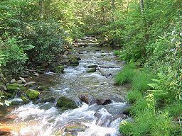
- Golden eagle trail in wolf run wild area at tiadaghton state forest pa
- History
- 2005 Realignment
- Hiking
- Natural areas
- Wild Areas
- Nearby state parks
- Neighboring state forest districts
- References
Map of Tiadaghton State Forest, Washington Township, PA 17752, USA
As of July 1, 2005 the state forest lands in eastern Lycoming County, which had been part of Tiadaghton State Forest, became part of the new Loyalsock State Forest. The main office for district #12 is in South Williamsport, in Lycoming County, Pennsylvania in the United States. There are plans to move it to the Pine Creek valley, perhaps to the village of Waterville. Tiadaghton is the Iroquois name for Pine Creek, but its meaning is unknown.
Golden eagle trail in wolf run wild area at tiadaghton state forest pa
History
As the timber was exhausted and the land burned, many companies simply abandoned their holdings. Conservationists like Dr. Joseph Rothrock became concerned that the forests would not regrow if they were not managed properly. They called for the state to purchase land from the lumber companies and for a change in the philosophy of forest management. In 1895 Rothrock was appointed the first commissioner of the Pennsylvania Department of Forests and Waters, the forerunner of today's Department of Conservation and Natural Resources. In 1897 the Pennsylvania General Assembly passed legislation which authorized the purchase of "unseated lands for forest reservations" and the first Pennsylvania state forest lands were acquired the following year.
On July 13, 1898, the state bought a 409-acre (166 ha) tract of land in Cummings Township for $72.99 ($2101 in 2017 terms). This was the first purchase for what became Tiadaghton State Forest, which surrounds the park. The state forest grew to 66,000 acres (27,000 ha) by 1908, and over 160,000 acres (65,000 ha) in 1933. Most of the major purchases for it were made between 1900 and 1935.
2005 Realignment
Prior to the July 1, 2005 realignment of Pennsylvania State Forest Districts, Tiadaghton State Forest included all state forest lands in Lycoming County and encompassed 215,500 acres (87,210 ha). After realignment, the state forest tracts in eastern Lycoming County became part of the new Loyalsock State Forest. The District #12 office will also move from South Williamsport to Waterville, at the confluence of Little Pine Creek and Pine Creek, where the largest part of the forest is now located. The southern tracts are along Bald Eagle Mountain, North White Deer Ridge, South White Deer Ridge, and the White Deer Hole Creek watershed.
As of 2009, the Tiadaghton State Forest covered 146,500 acres (59,300 ha), chiefly in Lycoming County with small tracts in Clinton, Potter, Tioga, and Union Counties. The largest section of the state forest consists of 105,000 acres (42,000 ha) in the Pine Creek valley.