
- left Brier Ditch Length 5 km Basin area 195.8 km² | Basin area 195.8 km² | |
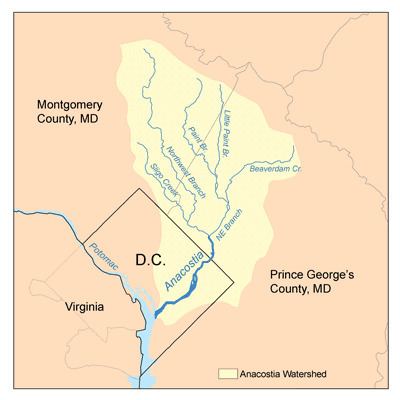 | ||
Northeast Branch Anacostia River is a 3.2-mile-long (5.1 km) free-flowing stream in Prince George's County, Maryland. It is a tributary of the Anacostia River, which flows to the Potomac River and the Chesapeake Bay.
Contents
- Map of Northeast Branch Anacostia River Maryland USA
- CourseEdit
- WatershedEdit
- GeologyEdit
- TributariesEdit
- References
Map of Northeast Branch Anacostia River, Maryland, USA
CourseEdit
The headwaters of the Northeast Branch are at the confluence of Indian Creek and Paint Branch, located on the eastern edge of the community of College Park. The stream flows southward for about 3 miles (5 km) to its confluence with the Northwest Branch near Bladensburg to form the mainstem of the Anacostia.
WatershedEdit
The Northeast Branch watershed in Prince George's County includes portions of the communities of Beltsville, Greenbelt, College Park, New Carrollton, Riverdale Park, Hyattsville, Berwyn Heights and Edmonston. Portions of the Paint Branch and Little Paint Branch tributaries also drain the Cloverly, Colesville, Fairland, White Oak and Hillandale communities in Montgomery County. Major institutions in the watershed include the Beltsville Agricultural Research Center, University of Maryland, College Park and Greenbelt Park. The total watershed area, including tributaries, is 75.6 square miles (196 km2), with a resident population of about 246,530.
GeologyEdit
Northeast Branch is located in the Atlantic coastal plain geologic region.
TributariesEdit
The total stream channel length of Northeast Branch and all tributaries is 12.1 miles (19.5 km).