
State Maryland Town Town of Berwyn Heights FIPS code 24-06925 Area 179 ha Local time Saturday 8:14 PM Area code 301 | Time zone Eastern (EST) (UTC-5) Elevation 34 m Zip code 20740 Population 3,212 (2013) | |
 | ||
Weather 1°C, Wind N at 8 km/h, 36% Humidity | ||
Berwyn Heights (after the newly constructed Presbyterian Church that was called the Berwyn Chapel, which was named after a recently deceased son of a benefactor of the chapel), officially the Town of Berwyn Heights, is a town in Prince George's County, Maryland. The population was 3,123 at the 2010 United States Census. It is bordered by College Park to the west, Greenbelt to the northeast, and Riverdale Park to the south.
Contents
- Map of Berwyn Heights MD 20740 USA
- History
- Historic sites
- Geography
- 2010 census
- 2000 census
- Education
- Government
- Past Mayors
- Taxation
- Civic Activities
- References
Map of Berwyn Heights, MD 20740, USA
History
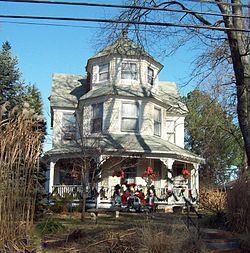
Beginning in the 1870s, the area northeast of Washington, D.C. was the scene of active and continuous development as the population of the city increased and railroad suburbs such as Berwyn Heights, originally platted as Charlton Heights, gradually grew and expanded around it. The O'Dea House, listed on the National Register of Historic Places, is one of the homes that was erected in 1888 by the Charlton Heights Improvement Company to spur development in the new subdivision.
In 1896, it became the seventh incorporated municipality in Prince George's County. In 1967, it adopted its town seal, which contains three acorns. In 1986, it was awarded the Tree City USA title.
Historic sites
A group of the remaining original houses is located around Ruatan Street. Four of the houses were built from mail-order plans made by R. W. Shoppell's Cooperative Building Plan Association of New York City. The following is a partial list of historic sites in Berwyn Heights identified by the Maryland-National Capital Park and Planning Commission:
Geography
Berwyn Heights is located at 38°59′38″N 76°54′44″W (38.993810, -76.912344). According to the United States Census Bureau, the town has a total area of 0.69 square miles (1.79 km2), all of it land.
2010 census
As of the census of 2010, there were 3,123 people, 1,002 households, and 681 families residing in the town. The population density was 4,526.1 inhabitants per square mile (1,747.5/km2). There were 1,051 housing units at an average density of 1,523.2 per square mile (588.1/km2). The racial makeup of the town was 56.0% White, 15.1% African American, 0.8% Native American, 8.4% Asian, 0.1% Pacific Islander, 14.4% from other races, and 5.1% from two or more races. Hispanic or Latino of any race were 27.1% of the population.
There were 1,002 households of which 34.3% had children under the age of 18 living with them, 50.1% were married couples living together, 11.0% had a female householder with no husband present, 6.9% had a male householder with no wife present, and 32.0% were non-families. 20.1% of all households were made up of individuals and 7.6% had someone living alone who was 65 years of age or older. The average household size was 3.10 and the average family size was 3.42.
The median age in the town was 34.9 years. 21.7% of residents were under the age of 18; 12.1% were between the ages of 18 and 24; 31.1% were from 25 to 44; 24.3% were from 45 to 64; and 10.8% were 65 years of age or older. The gender makeup of the town was 52.4% male and 47.6% female.
2000 census
As of the census of 2000, there were 2,942 people, 1,022 households, and 713 families residing in the town. The population density was 4,552.9 people per square mile (1,747.6/km²). There were 1,047 housing units at an average density of 1,620.3 per square mile (621.9/km²). The racial makeup of the town was 71.79% White, 12.00% African American, 0.54% Native American, 8.57% Asian, 8.23% Hispanic or Latino, 4.38% from other races, and 2.72% from two or more races of the population.
There were 1,022 households out of which 27.5% had children under the age of 18 living with them, 54.8% were married couples living together, 10.1% had a female householder with no husband present, and 30.2% were non-families. 19.3% of all households were made up of individuals and 7.7% had someone living alone who was 65 years of age or older. The average household size was 2.86 and the average family size was 3.19.
In the town, the population was spread out with 20.9% under the age of 18, 10.7% from 18 to 24, 33.1% from 25 to 44, 22.5% from 45 to 64, and 12.9% who were 65 years of age or older. The median age was 36 years. For every 100 females there were 103.9 males. For every 100 females age 18 and over, there were 100.2 males.
The median income for a household in the town was $65,744, and the median income for a family was $69,013. Males had a median income of $42,525 versus $34,831 for females. The per capita income for the town was $25,793. About 0.9% of families and 5.5% of the population were below the poverty line, including 0.5% of those under age 18 and 1.6% of those age 65 or over.
Education
Berwyn Heights is served by the Prince George's County Public Schools: Berwyn Heights Elementary School, which is located in Berwyn Heights, Greenbelt Middle School (Greenbelt), and Parkdale High School (Riverdale Park).
Government
The Town Council consists of five members, who are elected every two years on an at-large plurality voting basis, to govern the Town of Berwyn Heights. The member of the council who received the most votes during the election becomes Mayor. The Mayor serves as the head of the government and presides at all Council meetings, but in other respects is an equal member of the Council. The Mayor Pro Tempore assumes the Mayoral duties in the absence of the Mayor.
The current Mayor is Cheryl Jewitt. The Town Administrator is Jessica Cowles.
The town has a police department, a public works department, a code enforcement department, and an administration department.
Past Mayors
Taxation
At 53 cents per $100 per assessed value, Berwyn Heights has one of the lowest real property tax rates in Prince George's County. In 2005, the town became the first municipality in Maryland to establish a Public Safety Taxing District, after it was authorized by the General Assembly. The district imposes a special tax on businesses to fund the cost of one full-time officer and helps maintain around the clock police coverage.
Civic Activities
The town also benefits from numerous town committees and organizations. The town, as of October 2008, has joined a State Retirement Pension, for its employees, and police officers. This was done in order to try to compete and to retain the police officers.
Sports Park, which is the home of a Berwyn Heights civic group, is located by Indian Creek.
Berwyn Heights Day is an yearly event that celebrates the founding of the town.