
State Maryland Time zone Eastern (EST) (UTC-5) GNIS feature ID 0597086 Zip code 20710 Population 9,433 (2013) | FIPS code 24-07850 Elevation 16 m Local time Saturday 1:36 PM Area code 301 | |
 | ||
Country United States of America Weather 3°C, Wind NW at 23 km/h, 29% Humidity Area 2.616 km² (259 ha Land / 3 ha Water) | ||
Bladensburg is a town in Prince George's County, Maryland, United States. The population was 9,148 at the 2010 census. Areas in Bladensburg have the ZIP code 20710. Bladensburg is 8.6 miles (13.8 km) from central Washington, D.C.
Contents
- Map of Bladensburg MD USA
- History
- Port and railroad 1740s 1830s
- 1840s present
- Historic sites
- Property taxes
- Geography
- Bordering areas
- 2010 census
- 2000 census
- Public schools
- Private schools
- Religion
- Notable people
- References
Map of Bladensburg, MD, USA
History
Originally called Garrison’s Landing, Bladensburg was renamed in honor of Thomas Bladen, governor of Maryland, 1742–1747. Bladensburg was established in 1742 as a regional commercial center by an act of the Maryland General Assembly. The act also authorized the town commissioners to purchase 60 acres (240,000 m2) of land to be laid out in 1-acre (4,000 m2) lots. The act required that a house covering at least 400 square feet (37 m2) of ground with a brick or stone chimney be constructed within 18 months of the sale of the lot. As of 6 June 1746, only 18 of the lots had been improved according to the stipulations of the act. Christopher Lowndes' house, Bostwick, and those built by David Ross and William Hilleary (the William Hilleary House) were among them.
Port and railroad (1740s-1830s)
With the establishment in 1747 of a government tobacco inspection system, Bladensburg became a designated tobacco inspection and grading port. The Market Master's House is evidence of that role.
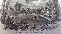
A seaport during the colonial period, Bladensburg is best remembered for the Battle of Bladensburg (1814) during the War of 1812, notable because it was the only battle in American history in which a sitting president (James Madison) rode into battle. America's eventual defeat, called "the greatest disgrace ever dealt to American arms", cleared the way for the burning of Washington by British troops. Its role as a seaport faded as the Anacostia River silted up and larger ships could no longer reach the port.
However, the town remained an important crossroads of routes north to Baltimore and Philadelphia, south and east to the towns of Annapolis and Upper Marlboro, and west to the District of Columbia. The original terminus of the Baltimore and Ohio Railroad was Bladensburg, forcing all passengers intended for Washington to board carriages to continue on into the city. A sharp decline of passengers was experienced in Bladensburg when an extension of the B&O was permitted into the District of Columbia in 1835.
1840s-present
Bladensburg remained a small town throughout the rest of the 19th century with modest development and infrastructure improvements. A major attraction in Bladensburg from the 18th century through the 20th century was the Spa Springs. Thought to be a cure for various illnesses, the springs attracted visitors from throughout the region and was reachable by the Washington, Spa Spring and Gretta Railroad. Another attraction was the Bladensburg Dueling Grounds or Dueling Creek, the site of many famous duels until after the American Civil War. The town was incorporated in 1854. Schools and churches were constructed, including the first Freedmen's Bureau school for African Americans in 1866. The town experienced its most significant growth in the early 20th century with the construction of the first two residential sections of the town in 1914 and 1917. Named Decatur Heights, the subdivisions had gridded streets platted on the north and south sides of Annapolis Road. The town was enlarged again in 1947 by the Sunnybrook subdivision. The mid to late 20th century brought additional residential construction in the form of single-family houses and apartment complexes, as well as the construction of the Bladensburg Shopping Center. After a history major flooding, the Army Corps of Engineers implemented a flood control system around this time that altered the course of the Anacostia River and added levees.
In 1999, Bladensburg, Colmar Manor, and Cottage City were lauded by the Joint Center for Sustainable Communities for their collaboration with Prince George's County for the Port Towns Revitalization Initiative, which created a common Port Towns identity for the towns; encouraged businesses development through infrastructure and façade improvements; acquisition of historic properties and plans for their reuse; and reconstruction of the Bladensburg waterfront and marina.
Historic sites
The following is a partial list of historic sites in Bladensburg identified by the Maryland-National Capital Park and Planning Commission:
Property taxes
Geography
Bladensburg is located at 38°56′29″N 76°55′48″W (38.941428, −76.930053).
According to the United States Census Bureau, the town has a total area of 1.01 square miles (2.62 km2), of which, 1.00 square mile (2.59 km2) is land and 0.01 square miles (0.03 km2) is water.
Bordering areas
2010 census
As of the census of 2010, there were 9,148 people, 3,542 households, and 1,960 families residing in the town. The population density was 9,148.0 inhabitants per square mile (3,532.1/km2). There were 3,826 housing units at an average density of 3,826.0 per square mile (1,477.2/km2). The racial makeup of the town was 12.6% White, 65.6% African American, 0.5% Native American, 2.0% Asian, 16.6% from other races, and 2.7% from two or more races. Hispanic or Latino of any race were 26.9% of the population.
There were 3,542 households of which 36.2% had children under the age of 18 living with them, 25.7% were married couples living together, 22.4% had a female householder with no husband present, 7.2% had a male householder with no wife present, and 44.7% were non-families. 37.0% of all households were made up of individuals and 12.7% had someone living alone who was 65 years of age or older. The average household size was 2.58 and the average family size was 3.39.
The median age in the town was 31.5 years. 26.8% of residents were under the age of 18; 11% were between the ages of 18 and 24; 32.7% were from 25 to 44; 20.3% were from 45 to 64; and 9.4% were 65 years of age or older. The gender makeup of the town was 46.9% male and 53.1% female.
2000 census
As of the census of 2000, there were 7,661 people, 3,121 households, and 1,719 families residing in the town. The population density was 7,766.1 people per square mile (2,987.8/km²). There were 3,443 housing units at an average density of 3,490.3 per square mile (1,342.8/km²). The racial makeup of the town was 16.42% White, 70.92% African American, 0.34% Native American, 2.52% Asian, 0.05% Pacific Islander, 6.87% from other races, and 2.88% from two or more races. Hispanic or Latino of any race were 13.07% of the population.
There were 3,121 households out of which 31.0% had children under the age of 18 living with them, 27.8% were married couples living together, 20.7% had a female householder with no husband present, and 44.9% were non-families. 37.6% of all households were made up of individuals and 10.6% had someone living alone who was 65 years of age or older. The average household size was 2.45 and the average family size was 3.26.
In the town, the population was spread out with 27.6% under the age of 18, 10.3% from 18 to 24, 34.0% from 25 to 44, 19.3% from 45 to 64, and 8.7% who were 65 years of age or older. The median age was 31 years. For every 100 females there were 91.0 males. For every 100 females age 18 and over, there were 85.2 males.
The median income for a household in the town was $34,966, and the median income for a family was $41,394. Males had a median income of $30,969 versus $28,538 for females. The per capita income for the town was $17,046. About 7.5% of families and 11.8% of the population were below the poverty line, including 9.5% of those under age 18 and 21.3% of those age 65 or over.
Public schools
Bladensburg residents are zoned to schools in the Prince George's County Public Schools district.
Public elementary schools serving the town include:
Private schools
Elizabeth Seton High School, a private high school, is located in Bladensburg.