
Listing Inactive volcano Region CALABARZON Elevation 709 m | ||
 | ||
Similar Taal Volcano, Mount Makiling, Mount Macolod, Mount Masaraga, Malepunyo Mountain Range | ||
Mount Sungay, also known as Mount Gonzales, is a mountain in the province of Cavite in the Philippines. Located in eastern Tagaytay, the inactive stratovolcano is the highest point of the province of Cavite at 709 metres (2,326 ft). The slopes of the mountain is the source of the San Cristobal River that flows from the mountain to Silang, Cavite down to its mouth at Laguna de Bay in Calamba, Laguna.
Contents
- Map of Mount Sungay Tagaytay Cavite Philippines
- Tagaytay Ridge
- Destruction
- Peoples Park in the Sky
- References
Map of Mount Sungay, Tagaytay, Cavite, Philippines
The mountain's former sharp peak and readily distinguishable shape made it a reliable landmark for bearing checks when sailing in and around Manila Bay during the early days of navigation.
Tagaytay Ridge
Mount Sungay is the eastern end of the Tagaytay Range, or more commonly known as the Tagaytay Ridge, a 32-kilometre (20 mi) ridge located at the southern part of the province with elevations averaging about 600 m (2,000 ft) above sea level. The ridge stretches west-southwest from Mount Sungay to Mount Batulao in Batangas province.
The ridge, which overlooks Taal Lake in Batangas province, is actually the northern rim of Taal Caldera. The 25 km × 30 km (16 mi × 19 mi) wide cavity of the ancient volcano is partially filled by Taal Lake with Taal Volcano, the second most active volcano in the country, situated near the middle of the lake. The northern slope of the ridge is gently rolling down slope till it reaches the sea level at Manila Bay, in contrast to the rapid drop in its southern slopes and east of Mount Sungay. At some places on the lakeside appear great escarpments of 20 m (66 ft) and more of altitude, that are almost vertical, as at Mahabangato, in Brgy. Banga, and at Balitbiring, in Brgy. Caloocan in Talisay, Batangas.
Tagaytay Ridge is part of the upland mountainous area of the province of Cavite, which include the communities of Magallanes, Amadeo, Tagaytay, Mendez, Alfonso, southern part of Maragondon and Carmona. The municipalities are situated at elevations above 400 meters (1,300 ft) with slopes of more than 2%.
Destruction
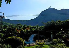
The mountain peak was previously much higher with an elevation of 752 meters (2,467 ft), Its former profile, "a sharp peak at the eastern end of a table of land (Tagaytay Ridge)", was one of the visible landmarks used by early navigators when sailing to and around Manila Bay. It was conical in shape with steep sides deemed "inaccessible", topped by distinct rock formations that resembled horns, (Tagalog: sungay), hence the name.
Mount Sungay was destroyed with the 1979 construction of First Lady Imelda Marcos's Palace in the Sky, a mansion originally intended as a guesthouse for former California Governor Ronald Reagan (who never arrived). This drastically changed the landscape of the Cavite highland, as the mountain was leveled to about half of its former prominence to accommodate the structure. The mansion remained unfinished after the People Power Revolution in 1986 that toppled the dictatorship of President Ferdinand Marcos. The new government renamed it the People's Park in the Sky, to show the excesses of the ousted regime.
People's Park in the Sky
The People's Park in the Sky, in now poised at the top of Mount Sungay, the highest point of the Province of Cavite. The park stands on a 4,516 square metres (48,610 sq ft) of solid ground and provides a 360-degree view of Cavite and the bordering provinces of Batangas and Laguna, to as far as Manila with a straight-line distance of about 50 km (31 mi). It overlooks four bodies of water – Taal Lake, Balayan Bay, Laguna de Bay and Manila Bay. Nearby mountains visible from Mount Sungay include Mount Makiling in Laguna/Batangas border; Mount Malepunyo and Mount Macolod in Batangas; and Mount Banahaw in Quezon.
Mount Sungay is located at Barangays Dapdap West and Dapdap East in Tagaytay, approximately 8 km (5.0 mi) east from the Tagaytay City Circle. A narrow road takes visitors near the top to the parking lot and entrance of the park. The mansion can be reached by a 300 m (980 ft) hike or by a jeepney.