
Listing Active volcanoUltra Elevation 2,170 m Provinces Laguna, Quezon | Last eruption 1909 Prominence 1,919 m | |
 | ||
Cities andmunicipalities Candelaria Dolores Liliw Lucban Majayjay Nagcarlan RizalSan Pablo Sariaya Tayabas Similar Mount Makiling, Mount Arayat, Taal Volcano, Mount Apo, Kanlaon | ||
Surviving mount banahaw hiking in the philippines ft anna rabtsun
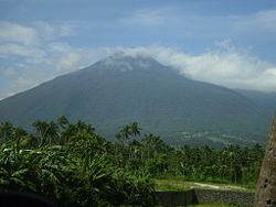
Mount Banahaw (alternative spelling: Banahao or Banájao) is an active volcano on Luzon in the Philippines. The three-peaked volcano complex is located between the provinces of Laguna and Quezon and is the tallest mountain in the CALABARZON Region dominating the landscape for miles around.
Contents
- Surviving mount banahaw hiking in the philippines ft anna rabtsun
- Map of Mount Banahaw Quezon Philippines
- Physical characteristicsEdit
- Importance to localsEdit
- Hiking activity on BanahawEdit
- PollutionEdit
- References
Map of Mount Banahaw, Quezon, Philippines
The mountain is considered by many as a "Holy mountain" and is popular among pilgrims along with mountain climbers. It is located in a protected area known as Mounts Banahaw–San Cristobal Protected Landscape covering 10,901 hectares (26,940 acres) of land.
Physical characteristicsEdit
The andesitic Banahaw volcano complex is composed of several mountains with Mount Banahaw, the largest with a maximum Elevation of 2,170 metres (7,119 ft) above mean sea level. The summit is topped by a 1.5 by 3.5 kilometres (0.93 mi × 2.17 mi) and 210 metres (690 ft) deep crater that is breached on the southern rim believed to have been caused by the 1730 eruption. Prior to 1730, a lake occupied the summit crater of Mount Banahaw. The resulting flood destroyed the town of Sariaya, Quezon located below the mountain.
Importance to localsEdit
Banahaw is a traditional pilgrimage site for locals, believed by many as a "Holy mountain", a spiritually-charged location. The mountain and its environs are considered sacred by local residents; the water from its sacred springs are deemed "holy water" for allegedly having beneficial qualities, issuing forth from locations called "puestos" or "holy sites". These sites are unique natural features composed not only of springs, but also caves, streams and boulders; with names with biblical allusions, and shrines erected in, on or around them. These locations were allegedly revealed to a man named Agripino Lontoc by the "Santong Boses" or the "Holy Voices", which also gave the names to these places way back during the Spanish Colonial Era. Another one of this mountain is the adjacent Mount Banahaw de Lucbán.
Hiking activity on BanahawEdit
The mountain is popular not only to pilgrims but also among mountain climbers being the closest over 2,000-metre (6,600 ft) mountain from Manila. Hiking activity peaks during Holy Week each year, with climbers numbering to the thousands. At least four trails exist from Dolores, Sariaya, and other towns of Quezon located on its foothills. The most frequently used trails are the Cristalino and Tatlong Tangke, taking an average of 9 and 5 hours, respectively. These two trails originate from Barangay Kinabuhayan in Dolores, and meet near the summit, which is actually the rim of the Banahaw caldera. On the summit are viewpoints, labeled as Durungawan I, II, and III, which are the usual destination for pilgrims and hikers. Other points of interest include the "Kuweba ng Diyos Ama" (Tagalog: Cave of God the Father) and the spring at Brgy. Kinabuhayan, said to have curative powers.
PollutionEdit
Due to incessant climbing activity the mountain trails have become littered with trash. In March 2004, the Department of Environment and Natural Resources ordered a 5-year suspension of hiking activity in the mountains, covering the Dolores and Sariaya trails. Reopening was delayed was then scheduled to March 2012, but was further extended to February 2015.