
Parent peak bagwis pt Region CALABARZON Elevation 963 m | Cities andmunicipalities Santo TomasLipa Province Batangas Age of rock Pliocene | |
 | ||
Similar Laguna Volcanic Field, Mount Macolod, Mount Banahaw, Mount Mayabobo, Mount Panay | ||
Malepunyo Range (also known as Malipunyo Range) is an extinct volcano located on Luzon Island in the Philippines. The mountain range is located between the provinces of Batangas, Laguna and Quezon. It is popular among mountaineers, and has three interconnected destinations: Mt. Malepunyo, the highest; Bagwis Peak (also known as Mt. Susong-Cambing); and Mount Dalaga (also known as Manabu Peak).
Contents
Map of Mount Malepunyo, Philippines
History
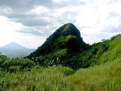
The Malepunyo Range is an inactive volcano to which its caldera is facing south along the vicinity between Lipa City and San Antonio, Quezon. By the 1990s the Malepunyo Mountain Range has been erroneously tagged as Malarayat Mountain Range due to the famous country club located at its western slope named after the Malarayat Hill. Mount Malepunyo is its highest peak located at Barangay Talisay, Lipa City standing at 1,002 metres (3,287 ft) above mean sea level by the ridge of its caldera. The second highest peak of the range is Mt. Dalaga standing at 755 metres (2,477 ft) above mean sea level situated at the boundary of Santo Tomas, Batangas and Alaminos, Laguna. During the 1990s, the name was changed by the locals of Santo Tomas to Manabu as a shortened Tagalog phrase Mataas na Bundok which means "High Mountain". At the center of the mountain range is a cliff known as Bagwis Cliff by the locals, yet due to its shape that resembles a goat's breast, it is also called as Susong-Kambing (en:Goat's Breast). In time, mountaineers have also mistakenly named this cliff as Susong Dalaga (en. maiden's breast) which is actually the oldest name of Manabu Peak. A discontinued highway project connecting San Pablo City and Lipa City that traverses the central part of the mountain range made way for the creation of what the mountaineers call as Biak na Bundok (en. Sliced Mountain).
Physical Characteristics
The Malepunyo mountain range has four notable peaks:
Product
The mountain range is a famous source of Alamid Coffee due to civet cats that chew on coffee beans and ferments the seeds inside its digestive system. The fermented coffee beans are then excreted along the trails and is cleaned and pulverized for coffee preparation.
Hiking
The jurisdiction of the Malepunyo Range is separated into two. The Manabu peak is under the jurisdiction of Santo Tomas, Batangas to which its jump-off is at Sitio Sulok. It resembles an easy trail to which a cross has been erected on its summit while a plateau beside it is used as a saddle camp. The southern half is under the jurisdiction of Lipa City, Batangas and the jump-off is located at Sitio Talisay. To which the trail leads to the summit of Mount Malepunyo. A class-4 trail connects Malipunyo to Manabu peak which passes through the vicinity of Bagwis Peak and the grassland plateau leading to Biak-na-Bundok and by the dense forest of the mountain range towards the plateau campsite of Manabu.