
Location Luzon Region CALABARZON Volcanic arc/belt Macolod Corridor Elevation 947 m Province Batangas | Last eruption Unknown Prominence 560 m | |
 | ||
Similar Mount Mayabobo, Taal Volcano, Mount Banahaw, Mount Makiling, Mount Arayat | ||
Mount maculot dayhike
Mount Macolod (also called Mount Makulot or Mount Maculot) is a mountain located in the town of Cuenca in Batangas province, in the Philippines. This mountain is popular among mountain climbers and campers; it is the major tourist attraction of the municipality. Every year on Holy Week, thousands of pilgrims from nearby towns and provinces climb the mountain as a form of penance.
Contents
- Mount maculot dayhike
- Map of Mount Macolod Cuenca Batangas Philippines
- Physical
- Geological history
- References
Map of Mount Macolod, Cuenca, Batangas, Philippines
Physical
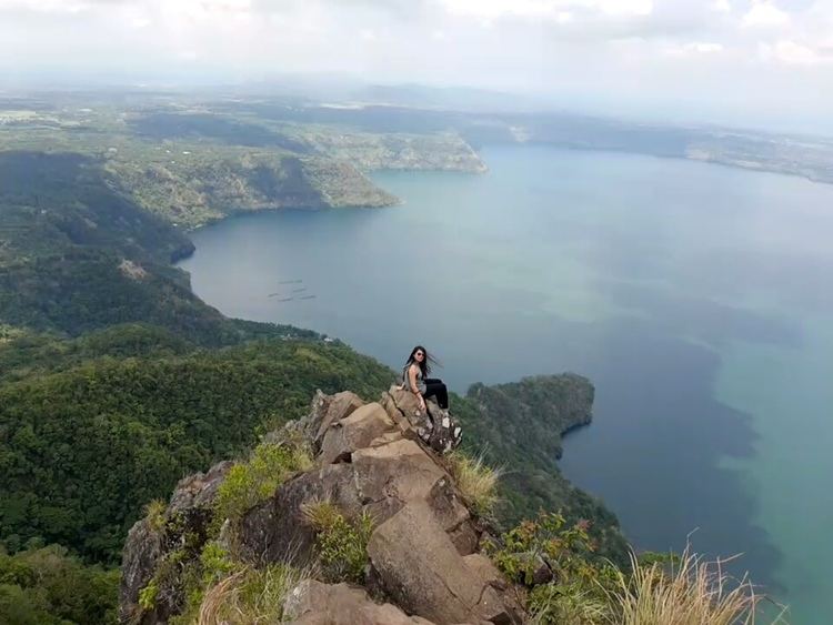
The mountain is about 947 m (3,107 ft) tall and is also located adjacent to Taal Lake. Mount Makulot and its 700-metre (2,300 ft) high volcanic rock wall called The Rockies, is said to be part of Taal Caldera's crater rim.
Geological history
Based on studies on Taal, it is believed that an ancient Taal Cone was formed by buildup of large volume dacitic pyroclastic materials more than 140,000 years ago. Several major catastrophic eruptions probably between 27,000 and 5,000 years ago destroyed this greater Taal Cone and ultimately formed the 25-by-30-kilometre (16 mi × 19 mi) wide depression now known as Taal Caldera. This depression was filled by water, thus forming a lake. The younger Volcano Island was formed by numerous explosive hydrovolcanic eruptions in the middle of the lake after the collapse.
The slopes of the previous volcano now formed ridges surrounding the lake. Mount Macolod is not only a volcanic cone on the south side but also the highest caldera rim of the former Taal Cone. Tagaytay Ridge, to the north, is the northern rim of the caldera with Mount Sungay its highest elevation.