
Country Area 3,263 km2 | Languages spoken Capital | |
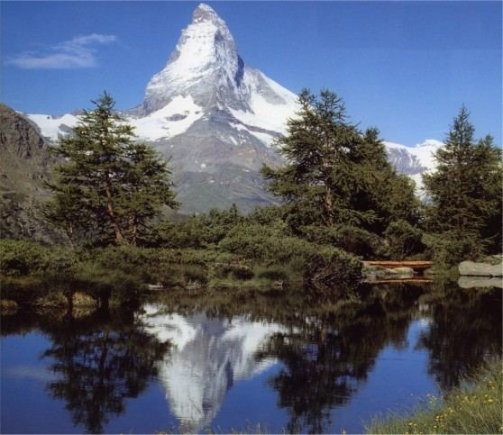 | ||
Destinations Aosta, Courmayeur, Breuil-Cervinia, La Thuile - Aosta Valley, Cogne Points of interest Matterhorn, Pointe Helbronner, Little St Bernard Pass, Notre Dame de Guerison sanctuary, Verres Castle | ||
GDP per capita 30,300.00 EUR (2008) University Aosta Valley University Population 128,466 (Jul 31, 2014) | ||
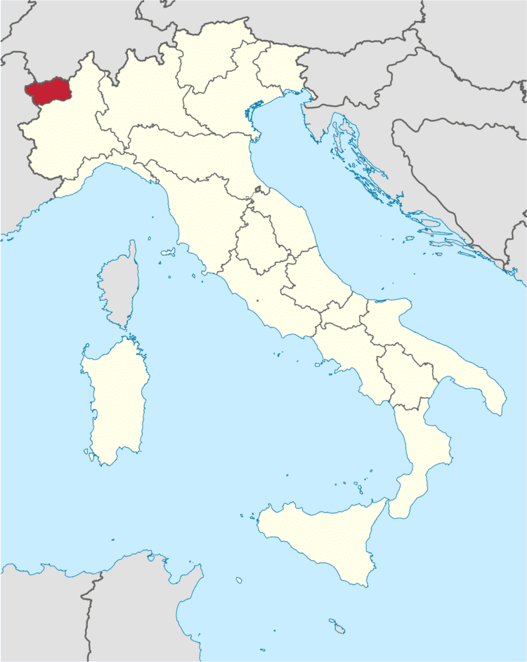
Map of Aosta Valley
The Aosta Valley (Italian: Valle d'Aosta [ˈvalle daˈɔsta] (official) or Val d'Aosta (usual); French: Vallée d'Aoste [vale dɔst] (official) or Val d'Aoste (usual); Arpitan: Val d'Outa; Walser German: Augschtalann or Ougstalland) is a mountainous autonomous region in northwestern Italy. It is bordered by Auvergne-Rhône-Alpes, France to the west, Valais, Switzerland to the north and by the Metropolitan City of Turin in the region of Piedmont, Italy, to the south and east.
Contents
- Map of Aosta Valley
- Aosta valley music institute visit
- Summer in the aosta valley
- Geography
- Climate
- History
- Government and politics
- Demographics
- Languages
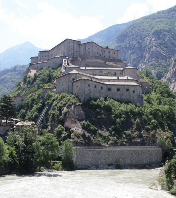
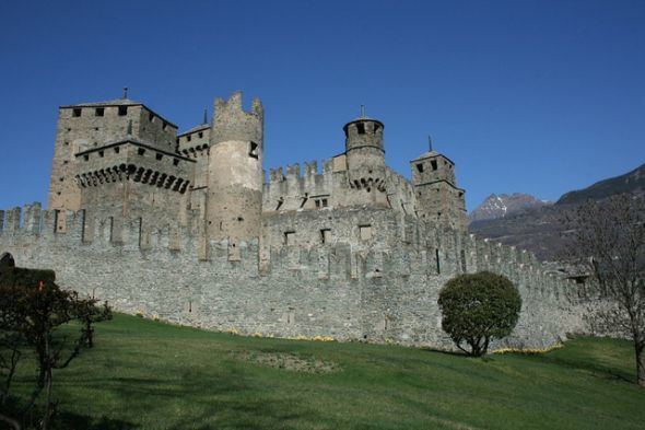
- Castles
- Cuisine
- Wine growing
- References
Covering an area of 3,263 km2 (1,260 sq mi) and with a population of about 128,000 it is the smallest, least populous, and least densely populated region of Italy. It is the only Italian region that is not sub-divided into provinces (the province of Aosta was dissolved in 1945). Provincial administrative functions are provided by the regional government. The region is divided into 74 comuni (communes).
Italian and French are the official languages, though much of the native population also speak Valdôtain, a dialect of Arpitan (Franco-Provençal), as their home language; about half of the population can speak all three languages.
The regional capital is Aosta.
Aosta valley music institute visit
Summer in the aosta valley
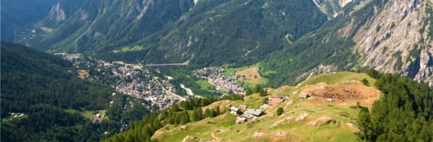
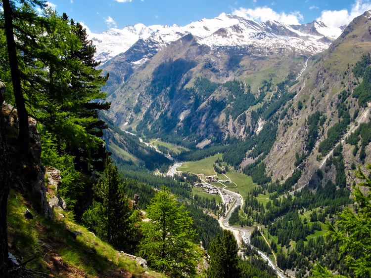
Geography
The Aosta Valley is an Alpine valley which with its tributary valleys includes the Italian slopes of Mont Blanc, Monte Rosa, Gran Paradiso and the Matterhorn; its highest peak is Mont Blanc (4.810 m).
Climate
The valleys, usually above 1600 metres, annually have a Cold Continental Climate (Dfc). In this climate the snow season is very long, as long as 8 or 9 months at the highest points. During the summer, mist occurs almost every day. These areas are the wettest in the western Alps. Temperatures are low, between −7 °C (19 °F) and −3 °C (27 °F) in January, and in July between 20 °C (68 °F) and 35 °C (95 °F). In this area is the town of Rhêmes-Notre-Dame., which may be the coldest town in the Western Alps and where the winter average temperature is around −7 °C (19 °F).
Areas between 2000 metres and 3500 metres usually have a Tundra Climate (ET), where every month has an average temperature below 10 °C (50 °F). This climate may be a kind of more severe Cold Oceanic Climate, with a low summer average but mild winters, sometimes above −3 °C (27 °F), especially near lakes, or a more severe Cold Continental Climate, with a very low winter average. Temperature averages in Pian Rosà, at 3400 metres high, are −11.6 °C (11.1 °F) in January and 1.4 °C (34.5 °F) in July. It is the coldest place in Italy where the climate is verifiable.
In the past, above 3500 metres, all months were having an average temperature below freezing, with a Perpetual Frost Climate (EF). In recent years though there was a rise in temperatures. See as an example the data for Pian Rosà.
History
The first inhabitants of the Aosta Valley were Celts and Ligures, whose language heritage remains in some local placenames. Rome conquered the region from the local Salassi around 25 BC and founded Augusta Prætoria Salassorum (modern-day Aosta) to secure the strategic mountain passes, and they went on to build bridges and roads through the mountains. Thus, the name Valle d'Aosta literally means "Valley of Augustus".
In 1031–1032 Humbert I of Savoy, the founder of the House of Savoy, received the title Count of Aosta from Emperor Conrad II of the Franconian line and built himself a commanding fortification at Bard. Saint Anselm of Canterbury was born in Aosta in 1033 or 1034. The region was divided among strongly fortified castles, and in 1191 Thomas I of Savoy found it necessary to grant to the communes a Charte des franchises ("Charter of Liberties") that preserved autonomy—rights that were fiercely defended until 1770, when they were revoked in order to tie Aosta more closely to Piedmont, but which were again demanded during post-Napoleonic times. In the mid-13th century Emperor Frederick II made the County of Aosta a duchy (see Duke of Aosta), and its arms charged with a lion rampant were carried in the Savoy arms until the reunification of Italy in 1870.
The region remained part of Savoy lands, with the exceptions of French occupations from 1539 to 1563, later in 1691, then between 1704 and 1706. As part of the Kingdom of Sardinia it joined the new Kingdom of Italy in 1861. It was also ruled by the First French Empire between 1800 and 1814. During French rule, it was part of Aoste arrondissement in Doire department.
The region gained special autonomous status after the end of World War Two; the province of Aosta ceased to exist in 1945.
Government and politics
For more than 20 years the valley has been in autonomist hands. As of the 2013 elections, the autonomist centre-right Valdostan Union together with autonomist Stella Alpina and Autonomist Federation retained its absolute majority in the Council of the Valley for the 8th time in a row.
Demographics
The population density of Aosta Valley is by far the lowest of the Italian regions. In 2008, 38.9 inhabitants per km2 were registered in the region, whereas the average national figure was 198.8, though the region has extensive uninhabitable areas of mountain and glacier, with a substantial part of the population living in the central valley. Migration from tributary valleys has now been stemmed by generous regional support for agriculture and tourist development.
The population is growing slowly but steadily. Negative population growth since 1976 has been more than offset by immigration. The region has one of Italy's lowest birth rates, with a rising average age. This, too, is partly compensated by immigration, since most immigrants arriving in the region are younger people working in the tourist industry. Between 1991 and 2001, the population of Aosta Valley grew by 3.1%, which is the highest growth among the Italian regions. With a negative natural population growth, this is due exclusively to positive net migration. Between 2001 and 2011, the population of Aosta Valley grew by a further 7.07%. As of 2006, the Italian National Institute of Statistics ISTAT estimated that 4,976 foreign-born immigrants live in Aosta Valley, equal to 4.0% of the total regional population.
The Valdôtain population and their language dialects have been the subject of some sociological research.
Languages
The Aosta Valley was the first government authority to adopt Modern French as the official language in 1536, three years before France itself. Italian and French are nowadays the region's official languages, and are used for the regional government's acts and laws, though Italian is much more widely spoken in everyday life, and French is mostly spoken in cultural life. Education is conducted evenly in French and Italian, so that anyone who has gone to school in the Aosta Valley can speak French to at least a medium-high level.
The regional language is a dialect of Franco-Provençal, called Valdôtain (locally, patoué, in the spelling that dialect). It is spoken as a native and second language by 68,000 residents, or about 58% of the population according to a poll taken by the Fondation Émile Chanoux in 2002. The residents of the villages of Gressoney-Saint-Jean, Gressoney-La-Trinité and Issime, in the Lys Valley, speak two dialects of Walser German, Titsch and Töitschu, respectively.
Castles
There are a numerous medieval castles and fortified houses in the Aosta Valley, including Argent Castle, Saint-Pierre Castle, Fénis Castle, Issogne Castle, Ussel Castle, Sarre Castle, Cly Castle, and Châtelard Castle. Savoy Castle in Gressoney-Saint-Jean was conceived in the 19th century and completed in 1904. Since 1990, it has also been home to the Savoy Castle Alpine Botanical Garden.
Cuisine
The cuisine of Aosta Valley is characterized by simplicity and revolves around "robust" ingredients such as potatoes, polenta; cheese and meat; and rye bread. Many of the dishes involve Fontina, a cheese with PDO status, made from cow's milk that originates from the valley. It is found in dishes such as the soup à la vâpeuleunèntse (Valpelline Soup). Other cheeses made in the region are Toma and Seras. Fromadzo (Valdôtain for cheese) has been produced locally since the 15th century and also has PDO status.
Regional specialities, besides Fontina, are Motzetta (dried chamois meat, prepared like prosciutto), Vallée d'Aoste Lard d'Arnad (a cured and brined fatback product with PDO designation), Vallée d’Aoste Jambon de Bosses (a kind of ham, likewise with PDO designation), and a black bread.
Notable dishes include Carbonnade, consisting of salt-cured beef cooked with onions and red wine served with polenta; breaded veal cutlets called costolette; teuteuns, salt-cured cow's udder that is cooked and sliced; and steak à la valdôtaine, a steak with croûtons, ham and melted cheese.
Wine growing
Notable wines include two white wines from Morgex (Blanc de Morgex et de La Salle and Chaudelune), a red wine blend from Arvier (Enfer d'Arvier), and a Gamay.