
Area 400 km² Phone +1 306-662-5411 | Established 1951 | |
 | ||
Governing body Alberta Tourism, Parks and Recreation and Saskatchewan Environment Address Hwy 21 South, Rural Municipality of Maple Creek, SK S0N 1N0, Canada Hours Open today · 8:30AM–5PMTuesday8:30AM–5PMWednesday8:30AM–5PMThursday8:30AM–5PMFriday8:30AM–5PMSaturdayClosedSundayClosedMonday8:30AM–5PM Management Government of Saskatchewan, Alberta Culture and Tourism Similar Cypress Hills, Fort Walsh, Elk Island National Park, Wood Buffalo National, Dinosaur Provincial Park | ||
Discover the hills cypress hills interprovincial park
Cypress Hills Interprovincial Park is an interprovincial park straddling the southern Alberta-Saskatchewan boundary, located southeast of Medicine Hat. It is Canada's first and only interprovincial park.
Contents
- Discover the hills cypress hills interprovincial park
- Cypress hills interprovincial park visions of the cypress hills part 1
- Geography
- Nature
- Fish species
- Activities
- History
- References
The park consists of two protected areas, the 345 km2 (133 sq mi) west block, that straddles the Alberta/Saskatchewan boundary between Alberta Highway 41, the townsite of Elkwater, Saskatchewan Highway 615, Saskatchewan Highway 271 and Fort Walsh, and the centre block, an additional area of 58 km2 (22 sq mi) in Saskatchewan, west of Saskatchewan Highway 21.
Cypress hills interprovincial park visions of the cypress hills part 1
Geography
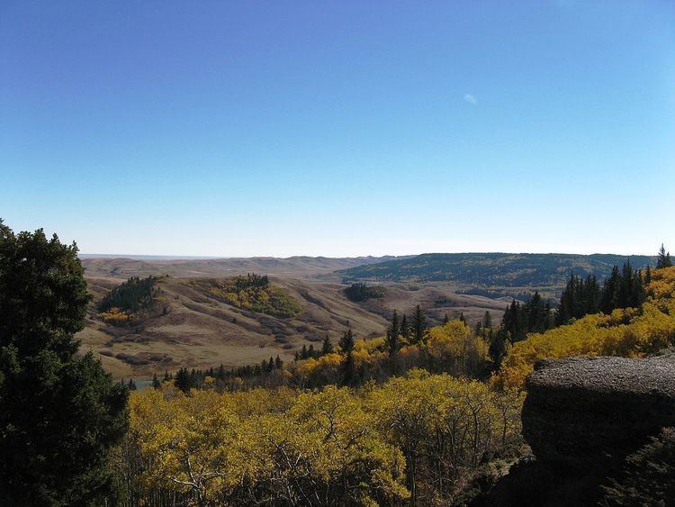
The Cypress Hills plateau rises up to 200 metres above the surrounding prairie, to a maximum elevation of 1,468 metres (4,816 ft) at "Head of the Mountain" at the west end in Alberta, making it Canada's highest point between the Canadian Rockies and the Labrador peninsula. Eastward across the boundary is the highest point in Saskatchewan, at 1,392 metres (4,567 ft). The "West Block" of the Cypress Hills spans the provincial boundary. Battle Creek runs through the central part of the park. Although the hills seem relatively low, in a larger geographic context the plateau does rise gradually from many kilometres away so that the total elevation gain from Medicine Hat is approximately 600 metres.
Nature
Approximately 700 species of plants and animals thrive in the park, including 14 species of orchids.
The park protects the majority of the Cypress Hills landscape, which consists of three separate elevated blocks of lush forest and fescue grassland surrounded by dry mixed-grass prairie. The "west block" and "centre block" are protected as provincial parks, and are managed by Alberta Parks and Protected Areas and Saskatchewan Parks, respectively. The "east block" of the Cypress Hills, situated near Eastend, Saskatchewan, is not part of the park. The Fort Walsh National Historic Site is also located in the park's limits.
Fish species
Fish species include walleye, yellow perch, northern pike, brook, brown, westslope cutthroat and rainbow trout, burbot, common carp, white sucker, and shorthead redhorse.
Activities
On the Alberta side of the west block, key park features include Head of the Mountain Viewpoint, the highest point between the Rocky Mountains and Labrador, the Elkwater townsite (a cottage community sitting at the same elevation as the Banff townsite), Horseshoe Canyon and Reesor Lake viewpoints (offering 100 km views on a clear day), over 50 km of hiking and mountain biking trails, and Hidden Valley Ski Area. Three lakes sit on the Alberta side of the park (Elkwater Lake, Spruce Coulee Reservoir and Reesor Lake), with another four in Saskatchewan (Harris, Adams, Coulee Lake and Loch Leven).
All year long, park interpreters present education programs to school and youth groups, adult and seniors groups, and a wide range of park visitors.
There are also various rentals to be used in the park in the various months. In summertime, kayak, canoe, bicycle, and water bikes are available for rental. In the winter, kicksleds, snowshoes, and cross country skis may be rented.