
Country Canada Census division 1 Time zone MST (UTC-7) Elevation 752 m Population 5,600 (2016) | Postal code span T0J Area 16.2 km² Local time Sunday 7:26 AM | |
 | ||
Weather -2°C, Wind SW at 16 km/h, 78% Humidity | ||
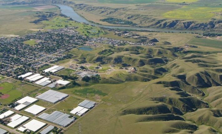
Redcliff is a town in southern Alberta, Canada within Cypress County. Bordering the City of Medicine Hat to the south and east, the town is bisected by Highway 1 (Trans-Canada Highway) and is located on the north bank of the South Saskatchewan River.
Contents
Map of Redcliff, AB, Canada
Situated at a high elevation relative to the surrounding landscape, the Town of Redcliff offers views of the South Saskatchewan River valley, the City of Medicine Hat, and Cypress Hills. The cliffs that overlook the river valley resemble badland formations.
History
Redcliff's history began in the 1880s with the discovery of abundant coal and natural gas reserves. Access to this inexpensive resource led to Redcliff being promoted as the "Smokeless manufacturing centre of the West". This drew industries that manufactured diverse products such as shoes, gloves, cigars, trucks, bricks, glass, and flour among others. In June 1915, a tornado (at the time called a cyclone) ravaged several of these businesses, thus starting a decline in Redcliff's economy. World War I and a flu epidemic ended the economic prosperity. The community experienced a resurgence in growth following World War II.
The name of the town originated from the elevated red shale banks of the South Saskatchewan River.
Demographics
In the 2016 Census of Population conducted by Statistics Canada, the Town of Redcliff recorded a population of 5,600 living in 2,159 of its 2,232 total private dwellings, a 6999200000000000000♠0.2% change from its 2011 population of 5,588. With a land area of 16.25 km2 (6.27 sq mi), it had a population density of 344.6/km2 (892.5/sq mi) in 2016.
In the 2011 Census, the Town of Redcliff had a population of 5,588 living in 2,083 of its 2,195 total dwellings, a 9.2% change from its 2006 adjusted population of 5,116. With a land area of 16.2 km2 (6.3 sq mi), it had a population density of 344.9/km2 (893.4/sq mi) in 2011.
The town had a population of 4,372 in 1,618 dwellings, a 6.5% increase from 1996. On a surface of 10.48 square kilometres (4.05 sq mi) it had a density of 417.2 inhabitants per square kilometre (1,080/sq mi).
Economy
The primary industries that support the local economy relate to oil and gas and the climate of southern Alberta. Numerous businesses in Redcliff and area provide drilling and pipeline services to support the oil and gas industry. The area's sunny climate and abundance of affordable natural gas reserves has contributed to the establishment of a sizable greenhouse industry. Greenhouse products include vegetables (sweet bell peppers, beefsteak tomatoes, tomatoes on the vine, and long English cucumbers), a variety of flowering plants, and some trees.
In the past, Redcliff was known for the production of glass, brick and pottery products. Some of these factories have since moved to Medicine Hat, such as the IXL brick plant, while others are no longer in existence.
Redcliff is a member of the Economic Development Alliance of Southeast Alberta.
Culture
Attractions
Redcliff has the following attractions:
Education
The Prairie Rose School Division No. 8 operates the following three schools in Redcliff that provide programming for children from kindergarten through grade 9.
High school students attend Eagle Butte High School in Dunmore, or enter the Medicine Hat School District No. 76 or Medicine Hat Catholic Separate Regional Division No. 20 for grades 10 through 12.