
 | ||
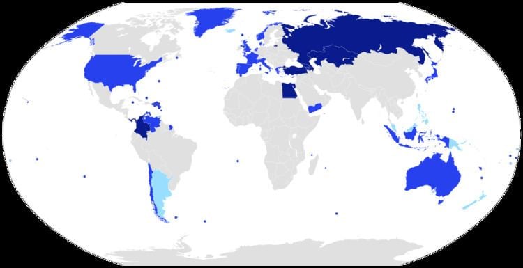
This is a list of countries located on more than one continent, known as transcontinental states or intercontinental states. While there are many countries with non-contiguous overseas territories fitting this definition, only a limited number of countries have territory straddling an overland continental boundary, most commonly the line that separates Europe and Asia.
Contents
- Africa and Asia
- Egypt
- Asia and Europe
- Historical variations
- North and South America
- North America and Europe
- Europe and North America
- Europe North America South America Oceania and Africa
- Africa and Europe
- Asia and Africa
- Asia and Oceania
- North America Oceania and Asia
- Other examples
- Antarctica claims
- References
The boundary between Europe and Asia is purely conventional, and several conventions remained in use well into the 20th century. However, the now-prevalent convention, used for the purposes of this page, follows the Caucasus northern chain, the Ural River and the Ural Mountains. It has been in use by some cartographers since about 1850. This convention results in several countries finding themselves almost entirely in "Asia", with a few small enclaves or districts technically in "Europe". Notwithstanding these anomalies, this list of transcontinental or intercontinental states respects the convention that Europe and Asia are full continents rather than subcontinents or component landmasses of the larger Eurasian continent.
Listed further below, separately, are countries with distant non-contiguous parts (overseas territories) on separate continents.
Africa and Asia
The land border between Asia and Africa is considered to go along the Isthmus of Suez and the Suez Canal in Egypt. The border continues through the Gulf of Suez, Red Sea and Gulf of Aden.
Egypt
Two of 27 governorates of Egypt lie entirely on the Asian Sinai Peninsula and two are transcontinental: Ismailia Governorate is nearly equally divided by the Suez Canal, and Suez Governorate, which is coterminous with the transcontinental city of Suez, has a small portion east of the Canal.
Asia and Europe
Since there is no significant geographical separation between Europe and Asia north of the Black Sea, the border between the two is largely an arbitrary, historical, and cultural construct. An often cited definition of the Europe–Asia border is said to follow the Aegean Sea, the Turkish Straits, the Black Sea, along the watershed of the Greater Caucasus, the northwestern portion of the Caspian Sea and along the Ural River and Ural Mountains to the Arctic Ocean. These delineations, however, are not definitive. For instance, the National Geographic places Cyprus entirely in Asia, and its geomorphology is similar to Asia; however the country is politically a member of the European Union, and it has an ethnic majority of Greek speaking Greek Cypriots and minority of Turkish speaking Turkish Cypriots. Similarly, although Georgia lies on the arbitrary Europe–Asia border, it is generally considered to be part of Europe. A further complication arises from the fact that Siberia lies east of the Ural Mountains, but is not politically, geologically, or culturally distinct from European Russia.
The Turkish city Istanbul lies on both sides of the Bosporus (one of the Turkish Straits), making it a transcontinental city. Çanakkale is also a Turkish city situated on two continents. Russia, Azerbaijan and Turkey are transcontinental countries with territory in both Europe and Asia by any definition except that of Eurasia as a single continent. While Russia is historically a European country with a history of imperial conquests in Asia, the situation for Turkey is inverse, as that of an Asian country with imperial conquests in Europe. Kazakhstan is also a transcontinental country by this definition, its West Kazakhstan and Atyrau provinces extending on either side of the Ural River. Despite its bi-continental placement, Kazakhstan's physical, cultural, and geographic characteristics are more similar to those of the other Central Asian countries.
This Ural River delineation is the only segment not to follow a major mountain range or wide water body, both of which often truly separate populations. However, the Ural River is the most common division used by authorities, is the most prominent natural feature in the region, and is the "most satisfactory of those (options) proposed" which include the Emba River, a much smaller stream cutting further into Central Asian Kazakhstan. The Ural River bridge in Orenburg is even labeled with permanent monuments carved with the word "Europe" on one side, "Asia" on the other.
Historical variations
The threefold division of the Old World into Europe, Asia and Africa has been in use since the 6th century BC, due to Greek geographers such as Anaximander and Hecataeus. The boundary between Europe and Asia is somewhat unusual among continental boundaries because of its largely mountain-and-river-based characteristics north and east of the Black Sea. Europe can be considered more of a subcontinent within Eurasia in de facto terms, and it has sometimes been referred to as such.
Anaximander placed the boundary between Asia and Europe along the Phasis River (the modern Rioni) in the Caucasus (from its mouth by Poti on the Black Sea coast, through the Surami Pass and along the Kura River to the Caspian Sea), a convention still followed by Herodotus in the 5th century BC.
North and South America
The most common demarcation in atlases and other sources follows the Darién Mountains watershed divide along the Colombia-Panama border where the Isthmus of Panama meets the South American continent. This puts Panama entirely in North America and mainland Colombia entirely in South America.
North America and Europe
Iceland is on the fracture line splitting the Northern Atlantic Ocean between the North American plate and the Eurasian plate. Measuring to the North American island of Greenland, Iceland is much closer to North America than it is to Europe; however it is over twice as close to mainland Europe as to mainland North America. Using a plate tectonics definition, Iceland would qualify as a transcontinental country. However, "continents" are defined by conventions that predate any knowledge of plate tectonics, even though many of the plates are named for the continents that occupy them. Geographically, ethnically, historically, and culturally, Iceland is commonly considered to be European and not transcontinental. Iceland is a full member of the Council of Europe (but still not in the European Union, to which it could qualify).
Asia and Europe
Europe and North America
Europe, North America, South America, Oceania, and Africa
Africa and Europe
Asia and Africa
Asia and Oceania
North America, Oceania and Asia
North and South America
North American Caribbean islands belonging to South American countries:
South American Caribbean islands:
Other examples
These examples have integral parts associated with other continents. Norway, South Africa, and the United Kingdom may also be considered transcontinental by virtue of their distant island possessions or territories associated with a continent other than where the country is based.
Antarctica: claims
A number of nations claim ownership over portions of the continent of Antarctica. Some, including Argentina and Chile, consider the Antarctic land they claim to be integral parts of their national territory. Some nations also have sub-Antarctic island possessions north of 60°S latitude and thus recognized by international law under the Antarctic Treaty System, which holds in abeyance land claims south of 60°S latitude.