
Location Japan Criteria ix UNESCO region Asia-Pacific | Type Natural Reference 1362 UNESCO World Heritage Site inscription 2011 | |
 | ||
Surfing in japan s ogasawara bonin islands on unesco s world heritage list
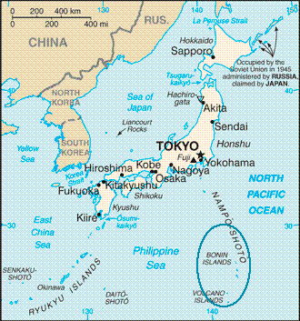
The Bonin Islands, also known as the Ogasawara Islands (小笠原群島, Ogasawara Guntō), are an archipelago of over 30 subtropical and tropical islands, some 1,000 kilometres (540 nmi; 620 mi) directly south of Tokyo, Japan. The name "Bonin Islands" comes from the Japanese word bunin (an archaic reading of 無人 mujin), meaning "no people" or "uninhabited". The only inhabited islands of the group are Chichi-jima (父島), the seat of the municipal government, and Haha-jima (母島), which includes Ogasawara Village.
Contents
- Surfing in japan s ogasawara bonin islands on unesco s world heritage list
- Geography and administrationEdit
- HistoryEdit
- Early claimsEdit
- British possessionEdit
- Japanese possessionEdit
- Demography language and educationEdit
- TransportationEdit
- Transportation issuesEdit
- FormationEdit
- FloraEdit
- FaunaEdit
- GeographyEdit
- References
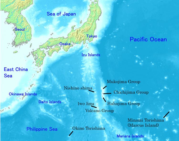
Ogasawara Municipality (mura) and Ogasawara Subprefecture (Tokyo Metropolis) take their names from the Ogasawara Group. However, Ogasawara Archipelago (小笠原諸島, Ogasawara shotō), may also be a wider collective term that includes other islands in Ogasawara Municipality, such as the Volcano Islands, along with other small, uninhabited and isolated islands. Geographically speaking, all of these islands are part of the Nanpō Islands.
A total population of 2,440, comprising 2,000 on Chichi-jima and 440 on Haha-jima, lives in the Ogasawara Group, which have a total area of 84 square kilometres (32 sq mi).
Because the Ogasawara Islands have never been connected to a continent, many of their animals and plants have undergone unique evolutionary processes. This has led to the islands' nickname of the "The Galápagos of the Orient", and their nomination as a natural World Heritage Site on June 24, 2011. The giant squid (genus Architeuthis) was filmed off the Ogasawara Islands for the first time in the wild on September 27, 2005, and was captured in December 2006.
A 25-meter-diameter radio telescope is located in Chichijima, one of the stations of the VLBI Exploration of Radio Astrometry (VERA) project, and is operated by the National Astronomical Observatory of Japan.
Geography and administrationEdit
The Bonin Islands consist of three subgroups, which are listed below along with their main islands:
Administratively, the Volcano Islands, Nishinoshima (Rosario Island), Okinotorishima (Parece Vela) and Minamitorishima (Marcus Island), are today part of Ogasawara municipality. Geographically, they are not traditionally considered part of the Bonin Islands, which are the Mukojima, Chichijima, and Hahajima island clusters. In other words, the historical range of the Bonin Islands (Ogasawara Guntō) is not the precise equivalent of the Japanese governmental unit. The Bonin Islands is a geographical term excluding the other islands which are today associated within the boundaries of a collective term, Ogasawara Shotō.
HistoryEdit
Prehistoric tools and carved stones, discovered on North Iwo Jima at the end of the 20th century, as well as stone tools discovered on Chichi-jima, indicate the islands might have been populated in ancient times.
Early claimsEdit
The first recorded visit by Europeans to the islands happened on 2 October 1543, when the Spanish explorer Bernardo de la Torre sighted Haha-jima, which he charted as Forfana. At that time, the islands were not populated.
Japanese discovery of the islands occurred in Kanbun 10 (1670) and was followed by a shogunate expedition in Enpō 3 (1675). The islands were claimed as a territory of Japan. They were then referred to as Bunin jima (無人島, Buninjima), literally "the uninhabited islands". In 1727, Ogasawara Sadato (小笠原 貞任, Ogasawara Sadato), a ronin, claimed that the islands were discovered by his ancestor Ogasawara Sadayori (小笠原 貞頼, Ogasawara Sadayori), in 1593, (Tensho 20), and the territory was granted as a fief by Toyotomi Hideyoshi. However, investigation of the claim found that it was a fraud and the very existence of Sadayori was doubtful; as a punishment Sadato was exiled by the shogunate (1735).
The first published description of the islands in the West was brought to Europe by Isaac Titsingh in 1796. His small library of Japanese books included Sangoku Tsūran Zusetsu (三国通覧図説, An Illustrated Description of Three Countries) by Hayashi Shihei. This book, which was published in Japan in 1785, briefly described the Ogasawara Islands.
These groups were collectively called Islas del Arzobispo (Archbishop Islands) in Spanish sources of the 18th–19th century. This name is most likely due to an expedition organized by the Arzobispo (Archbishop) Pedro Moya de Contreras, Viceroy of New Spain, to explore the northern Pacific and the islands of Japan. Its main objective was to find the long sought and legendary islands of Rica de Oro (Rich in Gold), Rica de Plata (Rich in Silver) and the Islas del Armenio (Islands of the Armenian). After several years of planning and frustrated attempts the expedition finally set sail on 12 July 1587 commanded by Pedro de Unamuno. Even if it did revisit the Daitō Islands, already charted by Bernardo de la Torre in 1543, the expedition could not find the wanted islands after searching the positions where they were charted in contemporary references. Japanese maps at the time seem to have been rather inaccurate and therefore considered by some to be deliberately misleading. It is thought that this was an attempt to discourage colonization attempts by foreign nations. Frederick William Beechey used the Spanish name as late as 1831 and believed that the Japanese Boninsima referred to entirely different islands.
British possessionEdit
In 1827 Captain F. W. Beechey of HMS Blossom reached the island chain and claimed them as a British possession. A copper plate was removed from Blossom's hull and left on a beach as a marker of the claim:
"HBM Ship Blossom Capt F. W. Beechey took possession of this Group of Islands in the Name of and on the behalf of His Britannic Majesty George the IV on the 14th June 1827."
In 1830, Nathaniel Savory, an American, landed on the island of Chichijima in 1830 and formed the first permanent colony there, along with 29 other people from Hawaii, the continental United States and Europe. The first settlers were Richard Millichamp of Devon, England; Matteo Mazzaro of Dubrovnik, Austrian Empire (now in Croatia); Alden B. Chapin and Nathaniel Savory of Boston; Carl Johnsen of Copenhagen; as well as seven unnamed men and 13 women from the Kingdom of Hawaii.
Two years later the Oriental Translation Fund of Great Britain and Ireland published a posthumous, abridged publication of Titsingh's French translation of Sankoku Tsūran Zusetsu.
Further settlers arrived in 1846, aboard the whaling ship Howard. They established themselves initially in South Island. (One of them, a woman from the Caroline Islands named Hypa, died in 1897 age about 112, after being baptized on her deathbed.)
Commodore Matthew C. Perry of the United States Navy visited the islands in 1853 and bought property at Port Lloyd from Savory for $50. The US "Colony of Peel Island" (Chichijima) was created and Savory was appointed governor.
Japanese possessionEdit
In 1862 (Bunkyū 1), the islands were claimed by Japan, and in 1875 the Japanese government renamed them the Ogasawara Islands. The Japanese names of each island were resolved and 38 settlers from Hachijojima were sent the following year. In 1876 the islands were put under the direct control of the Home Ministry and the islanders of European and US ancestry were granted Japanese nationality in 1882. Jack London visited the islands in 1893 and published an account of his sojourn.
A history of the islands was compiled by Lionel Cholmondeley over the course of several years; and his work was published in London in 1915.
In 1917, 60–70 island people claimed ancestry among the 19th-century English-speaking settlers; however, in 1941, no Bonin people would acknowledge descent from these early colonists. The current residents include some who claim to be related to Nathaniel Savory. In the winter of 1920–1921, Russian Futurist painter David Burliuk lived in the Bonin Islands and painted several landscapes of the islands.
The Ogasawara islanders were relegated to an insignificant status up through the early Shōwa period. During World War II, most inhabitants were forcibly evacuated to the mainland. There was a Japanese military base on Chichijima run by a Major Sueo Matoba (的場 末男, Matoba Sueo), who was known for engaging in cannibalism and other acts on prisoners of war. He was executed for his crimes after the war. Future President George H. W. Bush's plane crashed in the ocean near Chichijima, and he was rescued by an American submarine. The Battle of Iwo Jima in 1945, one of the fiercest battles of World War II, was fought on a garrison island in this region of the Pacific.
Following World War II, the islands were controlled by the United States Navy, which expelled all residents except those descended from the original settlers and/or related to them by marriage, while allowing the return of pre-war inhabitants of White American or European, Micronesian or Polynesian ancestry. The islands were returned to Japanese control in 1968, after which other Japanese citizens were allowed to return.
In November 2013, a new volcanic island formed, provisionally named “Niijima”.
Demography, language and educationEdit
Virtually all of the Bonin Islands' inhabitants are Japanese citizens. This includes the significant proportion with ancestors from the United States, Europe and other Pacific islands, who can often be distinguished by their family names and ancestry, physical features or adherence to Christianity. During and after the US military occupation of 1946–68, a small minority of islanders opted for US citizenship and/or emigrated from the islands. However, most islanders with non-Japanese ancestry now appear to be reassimilating with the ethnic Japanese majority.
Japanese is the common language. Because settlers from the United States, Europe and other Pacific islands preceded ethnic Japanese residents, an English-lexified pidgin (creole), the Ogasawara Mixed Language (OML), emerged on the islands during the 19th century. This was the result of Japanese being hybridised with island English, resulting in a mixed language that can still be heard.
The Ogasawara Village municipality operates public elementary and junior high schools, while Tokyo Metropolitan Government Board of Education operates Ogasawara High School.
TransportationEdit
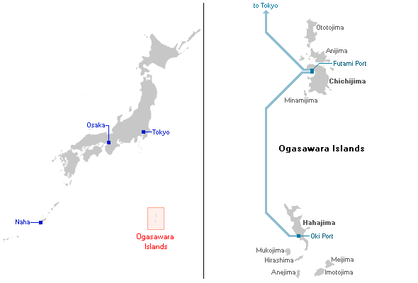
One can get from the main Japanese islands to Chichijima by way of the Ogasawara Maru liner, run by Ogasawara Marine Transportation. The ship leaves from Takeshiba pier in Tokyo Bay, and the trip takes around 25.5 hours (in good weather). There are four or five crossings each month.
The Ogasawara Maru is a 6,700 tonnes (6,600 long tons) vessel, 131-metre (430 ft) long, with a capacity of 1,031 passengers. To get to Hahajima, one must first get to Chichijima, and then cross by the liner Hahajima Maru.
Because a trip from the main Japanese islands to the Ogasawaras is very difficult, when people get severely ill or otherwise have an emergency, word is conveyed to the Iwo Jima Japan Maritime Self Defense Force post, and a helicopter is sent to the islands. Emergencies can also be handled from the main Japanese islands by Japan Air Self-Defense Force airplanes, or the Maritime Self Defense Force base in Iwakuni can convey evacuees to the main islands by seaplane, the ShinMaywa US-1. This seaplane is also used to transport the Tokyo governor and other VIPs.
Ogasawara Village operates a bus service on Chichijima and elderly passengers may use a "silver pass". There is also a sightseeing taxi service, a rental car company, motorized scooter rental services, a bike rental service, and other amenities. Bringing one's own automobile onto the island is extremely difficult and costly.
Transportation issuesEdit
The world's first "techno superliner", the Super Liner Ogasawara (which was to be commissioned in 2006), with a maximum speed of 38 knots (70 km/h; 44 mph), 14,500 tons gross tonnage, was expected to shorten the voyage to Ogasawara to about 17 hours and carry up to 740 passengers. However, the project was canceled in July 2005 due to rising fuel prices and the loss of ¥2 billion.
The Ogasawara Islands have no airport, and there is no prospect for one being constructed. However, for several decades there was talk of building one. Anijima and Chichijima were once designated possible construction sites, but because there are numerous valuable, rare, or endangered plant species forming a unique ecosystem in the vicinity of the proposed sites, issues of nature conservation were raised. Although construction of an airport was desired by some, a desire to keep the natural beauty of the islands untouched created a movement to block it. The airport issue was quite controversial on the islands.
FormationEdit
The Ogasawara (Bonin) Islands were formed around 48 million years ago. They are a part of the Izu-Bonin-Mariana Arc known geologically as a fore arc. They lie above a subduction zone between the Pacific Plate and the Philippine Sea Plate. The Pacific Plate is subducting under the Philippine Sea Plate, which creates an oceanic trench to the east of the islands: the Bonin Trench. The crust of the Ogasawara Islands was formed by volcanic activity when subduction began 45–50 million years ago, and is composed mostly of an andesitic volcanic rock called boninite, which is rich in magnesium oxide, chromium, and silicon dioxide. The Ogasawara Islands may represent the exposed parts of an ophiolite that has not yet been emplaced on oceanic crust. The rocks of the Volcano Islands are much younger; Iwo Jima is a dormant volcano characterized by rapid uplift and several hot springs.
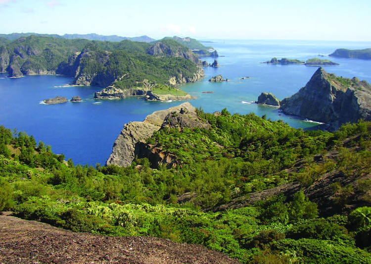
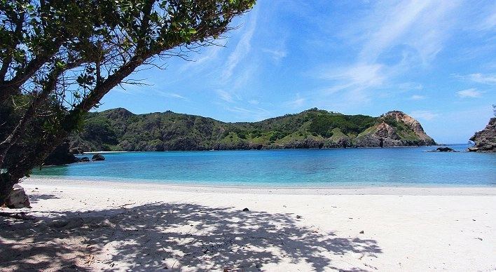
Most of the islands have steep shorelines, often with sea cliffs ranging from 50 to 100 metres (160 to 330 ft) in height, but the islands are also fringed with coral reefs and have many beaches. The highest point lies on South Iwo Jima, at 916 metres (3,005 ft).
FloraEdit
Flora has evolved differently on each of the islands. The Ogasawara Islands are sometimes referred to as the Galápagos of the Orient.
These islands are home to the northern most outliers of the Clinostigma genus of palms. C. savoryianum is endemic and has been planted in mediterranean climates often with success. Other unique species include Metrosideros boninensis, a plant related to similar species growing in Fiji and New Caledonia.
The Ogasawara Islands form a distinct subtropical moist broadleaf forest ecoregion, with a high degree of biodiversity and endemism. The islands are home to about 500 plant species, of which 43% are endemic. The forests are of three main types:
FaunaEdit
The range of the Bonin petrel extends beyond the Ogasawaras to include other islands in the northern Pacific region.
There are two restricted-range species of birds on the islands; the Japanese woodpigeon (Columba janthina) and the Vulnerable Bonin white-eye (Apalopteron familiare), formerly known as "Bonin honeyeater". The Japanese woodpigeon was extirpated in the Iwo Island groups in the 1980s.
A small bat, Sturdee's pipistrelle, is only known in one record and has not been seen since 1915. The Bonin flying fox (Pteropus pselaphon), also called the Bonin fruit bat, is endemic to the islands. It is currently listed as Critically Endangered, and a survey published by the Ogasawara Office of Education in 1999 estimated their number to be around 100.
GeographyEdit
The climate of Ogasawara Islands ranges from a humid subtropical climate (Köppen climate classification Cfa) to tropical savanna climate (Köppen climate classification Aw).
The climate of Chichi-jima in is on the boundary between the humid subtropical climate (Köppen classification Cfa) and the tropical savanna climate (Köppen classification Aw). Temperatures are warm to hot all year round owing to the warm currents from the North Pacific gyre that surround the island. Rainfall is less heavy than in most parts of mainland Japan since the island is too far south to be influenced by the Aleutian Low and too far from Asia to receive monsoonal rainfall or orographic precipitation on the equatorward side of the Siberian High. The wettest months are May and June, while the driest months are January and February.
Ogasawara’s easternmost island, Minamitorishima (Marcus Island) has the tropical savanna climate (Köppen classification Aw) with warm to hot temperatures throughout the year. The wettest months are July and August, while the driest months are February and March.