
Country Bolivia Mayor Luis A. Revilla Herrero | Area 472 km2 Population 789,585 (2001) | |
 | ||
Points of interest Colleges and Universities Higher University of San Andrés, Universidad Católica Boliviana, Universidad Nuestra Señora de La Paz | ||
Map of La Paz
La Paz, , officially known as Nuestra Señora de La Paz ([ˈnwes.tɾa seˈɲoɾa ðe la pas]; English: Our Lady of Peace), also named Chuqi Yapu (Chuquiago) in Aymara, is the seat of government of the Plurinational State of Bolivia. With an estimated 789,541 residents as of 2015, La Paz is the third-most populous city in Bolivia (after Santa Cruz de la Sierra and El Alto).
Contents
- Map of La Paz
- Things to do in la paz bolivia travel guide la paz
- History
- Geography
- Climate
- Main neighborhoods and zones
- Colonial architecture
- Economy
- Sports
- Education
- Tourism
- Museums and cultural centers
- Churches and cathedrals
- Other attractions
- Local festivals
- Transportation
- Highways
- Air
- Bus
- Cable car system
- La Paz traffic zebras
- Communications and media
- Water supply
- Twin towns and sister cities
- Notable people
- Curiosities
- Street food in la paz bolivia
- References
Its metropolitan area, which is formed by La Paz, El Alto and Viacha, makes up the most populous urban area in Bolivia, with a population of 2.3 million. It is also the capital of the La Paz Department.
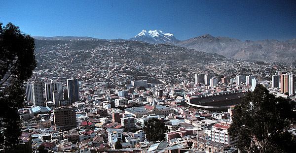
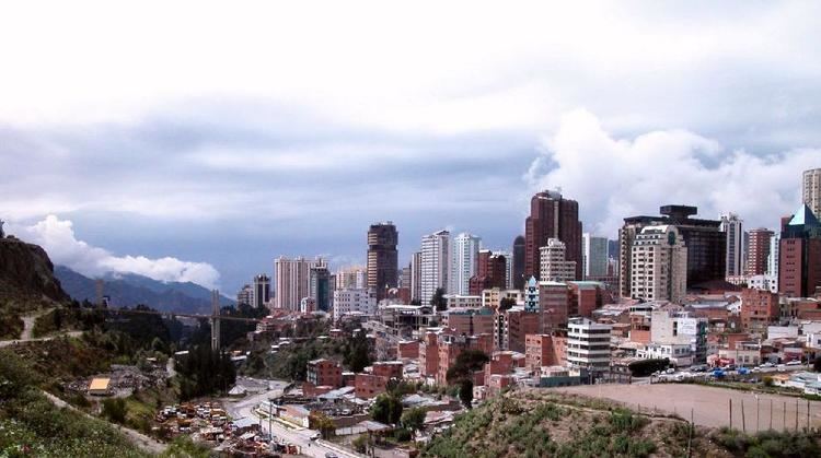
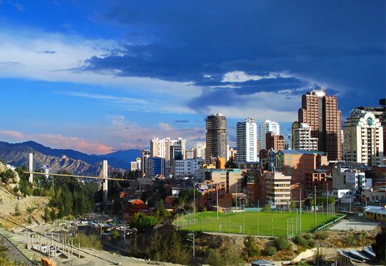
The city, located in west-central Bolivia 68 km (42 mi) southeast of Lake Titicaca, is set in a canyon created by the Choqueyapu River. It is located in a bowl-like depression surrounded by the high mountains of the Altiplano. Overlooking the city is the towering, triple-peaked Illimani. Its peaks are always snow covered and can be seen from many parts of the city. At an elevation of roughly 3,650 m (11,975 ft) above sea level, La Paz is the highest capital city in the world. Due to its altitude, La Paz has an unusual subtropical highland climate, with rainy summers and dry winters.
La Paz was founded on October 20, 1548 by the Spanish conquistador Captain Alonso de Mendoza at the site of the Inca settlement of Laja as a connecting point between the commercial routes that led from Potosí and Oruro to Lima; the full name of the city was originally Nuestra Señora de La Paz (meaning Our Lady of Peace) in commemoration of the restoration of peace following the insurrection of Gonzalo Pizarro and fellow conquistadors against the first viceroy of Peru. The city was later moved to its present location in the valley of Chuquiago Marka. La Paz was under Spanish colonial rule as part of the Viceroyalty of the Río de la Plata, before Bolivia gained independence. Since its founding, the city was the site of numerous revolts. In 1781, the indigenous leader and independence activist Túpac Katari laid siege to the city for a total of six months, but was finally defeated. On July 16, 1809 the Bolivian patriot Pedro Domingo Murillo ignited a revolution for independence, marking the beginning of the Spanish American Wars of Independence, which gained the freedom of South American states in 1821.
As the seat of the government of Bolivia, La Paz is the site of the Palacio Quemado, the Presidential Palace and seat of the Bolivian executive power, the Plurinational Legislative Assembly, and numerous government departments and agencies. Sucre is the constitutional capital of Bolivia and retains the judicial power. The city hosts numerous foreign embassies as well as international missions in the country. La Paz is an important political, administrative, economic, and sports center of Bolivia; it generates 25% of Bolivia's Gross Domestic Product and serves as the headquarters for numerous Bolivian companies and industries.
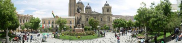
La Paz is also an important cultural center of Bolivia, as it hosts several landmarks belonging to the colonial times, such as the San Francisco Church, the Metropolitan Cathedral, the Plaza Murillo and the Jaén Street. The city is renowned for its unique markets, particularly the Witches' Market, and for its vibrant nightlife. Its unusual topography offers unique views of the city and the surrounding mountains of the Cordillera Real from numerous natural viewing points. La Paz is also home to both the longest and highest urban cable car network in the world. In May 2015, it was officially recognized as one of the New 7 Wonders Cities together with Beirut, Doha, Durban, Havana, Kuala Lumpur and Vigan. La Paz is listed on the Global Cities Index 2015, and is considered a global city type "Gamma" by Globalization and World Cities Research Network (GaWC).
Things to do in la paz bolivia travel guide la paz
History
This area had been the site of an Inca city, located on a major trading route.
Although the Spanish conquistadors entered the area in 1535, they did not found La Paz until 1548. Originally it was to be at the site of the Native American settlement, Laja, with the full name of the city being Nuestra Señora de La Paz (meaning Our Lady of Peace). The name commemorated the restoration of peace following the insurrection of Gonzalo Pizarro and fellow conquistadors four years earlier against Blasco Núñez Vela, the first viceroy of Peru. The town site was moved a few days later to its present location in the valley of Chuquiago, which is more clement.
Control over the former Inca lands had been entrusted to Pedro de la Gasca by the Spanish king (and Holy Roman Emperor) Emperor Charles V. Gasca commanded Alonso de Mendoza to found a new city commemorating the end of the civil wars in Peru; the city of La Paz was founded on October 20, 1548 by Alonzo de Mendoza, with Juan de Vargas appointed as its first mayor.
In 1549, Juan Gutierrez Paniagua was commanded to design an urban plan that would designate sites for public areas, plazas, official buildings, and a cathedral. These were meant to express the ideals and relationships of Spanish colonial society. La Plaza de los Españoles, which is known today as the Plaza Murillo, was chosen as the location for government buildings as well as the Metropolitan Cathedral.
Spain controlled La Paz with a firm grip and the Spanish king had the last word in all matters political, but consultation was extended, taking months or longer by sea. Indigenous and other unrest was repeated around the turn of the nineteenth century. In 1781, for a total of six months, a group of Aymara people laid siege to La Paz. Under the leadership of Tupac Katari, they destroyed churches and government property. Thirty years later Indians conducted a two-month siege against La Paz. This incident was the setting for the origin of the legend of the Ekeko. In 1809 the struggle for independence from the Spanish rule brought uprisings against the royalist forces. On July 16, 1809 Pedro Domingo Murillo said that the Bolivian revolution was igniting a lamp that nobody would be able to turn off. This uprising formally marked the beginning of the liberation of South America from Spain. The first open rebellions against the Spanish Crown took place in La Paz and the city of Sucre simultaneously. This event is known as the Primer Grito Libertario de América.
Pedro Domingo Murillo was hanged at the Plaza de los Españoles that night. After Bolivia gained independence, La Paz named this plaza after him, to commemorate him always. He is remembered as the voice of revolution across South America.
In 1825, after the decisive victory of the republicans at Ayacucho over the Spanish army in the course of the Spanish American wars of independence, the city's full name was changed to La Paz de Ayacucho (meaning The Peace of Ayacucho).
In 1898, La Paz was made the de facto seat of the national government, with Sucre remaining the nominal historical as well as judiciary capital. This change reflected the shift of the Bolivian economy away from the largely exhausted silver mines of Potosí to the exploitation of tin near Oruro, and resulting shifts in the distribution of economic and political power among various national elites.
Geography
Located at 16°30′0″S 68°08′0″W (−16.5, −68.1333), La Paz is built in a canyon created by the Choqueyapu River (now mostly built over), which runs northwest to southeast. The city's main thoroughfare, which roughly follows the river, changes names over its length, but the central tree-lined section running through the downtown core is called the Prado.
The geography of La Paz (in particular the altitude) is marked by social differences. The more affluent residents live in the lower, central areas of the city southwest of the Prado. Many middle-class residents live in high-rise condos near the center. Lower-income residents live in makeshift brick houses in the surrounding hills.
The satellite city of El Alto, in which the airport is located, is spread over a broad area to the west of the canyon, on the Altiplano. La Paz is renowned for its unique markets, unusual and dramatic topography, and traditional culture.
La Paz is located in the valleys of the Andes, close to the Eastern split of the Altiplano region. It is closer to such notable mountains as the Illimani (guardian of La Paz), Huayna Potosi, Mururata, and Illampu. On the Western side of the Altiplano divide, about an hour to the west of the La Paz, is the Sajama Volcano, the tallest mountain in Bolivia and ninth-tallest mountain in the Andes.
In July 1994, an earthquake rated at 8.2 struck just 200 miles (322 km) north of La Paz. It could be felt near La Paz and caused damage throughout the villages of the area.
Climate
At more than 4,000 metres (13,000 ft) above sea level, higher parts of La Paz have an unusual subtropical highland climate (Cwc, according to the Köppen climate classification), with subpolar oceanic characteristics (less than 4 months have a mean temperature above 10 °C), bordering on a tundra climate (ET). The whole city has rainy summers and dry winters. Night-time temperatures range from cold to very cold. Snow flurries can occur in winter, especially at dawn and it usually melts before noon. At these high altitudes despite being located only 16 degrees from the equator, the city's average temperature is similar to that of cities such as Bergen, Norway or Tórshavn, Faroe Islands, located as far as 60 and 62 degrees from the equator respectively.
The temperatures in the central La Paz, at 3,600 metres (11,811 feet), and in the Zona Sur (Southern Zone), at 3,250 m (10,663 ft) above sea level, are warmer (subtropical highland climate Cwb, according to the Köppen classification).
Owing to the altitude of the city, temperatures are consistently cool to mild throughout the year, though the diurnal temperature variation is typically large. The city has a relatively dry climate, with rainfall occurring mainly in the slightly warmer months of November to March.
At 4,012 metres, February and March, the two cloudiest months of the year, both in late summer, receive a low daily average of around 5 hours of sunshine. Conversely, June and July, the two sunniest months of the year, both in winter, receive an abundant daily average of around 8 hours of sunshine.
The seasonally uneven distribution of the year's annual precipitation often results in destructive mudslides experienced in summer, due to the excessive amount of precipitation typically observed throughout the season. At 3,250 metres, the wettest month is January with a monthly average of 114 mm (4.5 in) and the driest is July with 8 mm (0.3 in).
The warmest temperature recorded was 27.0 °C (80.6 °F) and the coldest was −12.5 °C (9.5 °F).
Main neighborhoods and zones
Colonial architecture
The city of La Paz has a consistently decreasing volume of colonial buildings, mostly centered around the vicinity of the Plaza Murillo. Due to a lack of funds and the inability of property owners to pay for restorations to colonial buildings, many have been torn down, or are in a dilapidated state. As historic buildings are more expensive to keep, land owners find it less of a burden to construct more modern buildings as opposed to keeping the old ones. Although there has been an increasing number of projects and propositions to restore some of the city's colonial buildings, the future of these historic edifices remains uncertain.
Economy
The economy of La Paz has improved greatly in recent years, mainly as a result of improved political stability. Due to the long period of high inflation and economic struggle faced by Bolivians in the 1980s and early 1990s, a large informal economy developed. Evidence of this is provided by the markets found all around the city. While there are stable markets, almost every street in the downtown area and surrounding neighborhoods has at least one vendor on it. La Paz remains the principal center of manufacturing enterprises that produce finished-product goods for the country, with about two-thirds of Bolivia's manufacturing located nearby. Historically, industry in Bolivia has been dominated by mineral processing and the preparation of agricultural products. However, in the urban centre of La Paz, small plants carry out a large portion of the industry. Food, tobacco products, clothing, various consumer goods, building materials, and agricultural tools are produced. "The tin quotations from London are watched in La Paz with close interest as an index of the country's prosperity; a third of the national revenue and more than half of the total customs in 1925 were derived from tin; in short, that humble but indispensable metal is the hub around which Bolivia's economic life revolves. The tin deposits of Bolivia, second largest in the world, ... invite development."
Sports
La Paz is the home of some of the biggest football teams in Bolivia.
The city is host to several other teams that play in the first and second divisions such as:
With the exception of Deportivo Municipal and Unión Maestranza, all the other teams play the majority of their games in the city stadium, the Estadio Hernando Siles, which also hosts the national football team and international games. Always Ready frequently play at the Estadio Rafael Mendoza which belongs to The Strongest, who rarely use the stadium due to its relatively small capacity.
Education
The city hosts some of the most important universities of the country:
Tourism
La Paz is an important cultural center of Bolivia. The city hosts several cathedrals belonging to the colonial times, such as the San Francisco Cathedral and the Metropolitan Cathedral, this last one located on Murillo Square, which is also home of the political and administrative power of the country. Hundreds of different museums can be found across the city, the most notable ones on Jaén Street, which street design has been preserved from the Spanish days and is home of 10 different museums.
The home of the Bolivian government is located on Murillo Square and is known as "Palacio Quemado" (Burnt Palace) as it has been on fire several times. The palace has been restored many times since, but the name has remained untouched.
Museums and cultural centers
Churches and cathedrals
Other attractions
Local festivals
Transportation
Automobiles and public transportation are still the main means to get into the city. In March 2012, more than 1.5 million vehicles were registered. Heavy traffic is common in the city center and traffic jams occur on peak hours.
Highways
The La Paz-El Alto Highway is a toll road that connects the city of La Paz with the neighboring city of El Alto. It is the city's main highway. It allows easy access to El Alto International Airport. The highway runs 11,7 km and crosses the city of El Alto:
The Southern District, one of La Paz's most affluent and commercial neighborhoods, is relatively separated from the rest of the city, including the CBD. The Avenida Costanera and Avenida Kantutani (Costanera and Kantutani Avenues) connect the southern district with the rest of the metropolitan area.
Air
El Alto International Airport (IATA code: LPB) is La Paz's national and international airport and a principal hub for Línea Aérea Amaszonas and Transporte Aéreo Militar. It also serves as a focus city for Boliviana de Aviación, Bolivia's flag-carrier and largest airline. The airport is located in the city of El Alto and is (13 km) south-west of La Paz's city center. At an elevation of 4,061 metres (13,323 feet), it is the highest international airport and fifth highest commercial airport in the world. The runway has a length of 4,000 metres (2.5 mi). It is one of Bolivia's three main international gateways, along with Jorge Wilstermann International Airport and Viru Viru International Airport.
International carriers serving El Alto International Airport include American Airlines, Avianca, Avianca Ecuador, LAN Airlines, LAN Perú, Peruvian Airlines and Sky Airline, which offer direct flights from La Paz to cities such as Miami, Bogotá, Lima, Iquique, Santiago and Cusco. However, most international traffic, including flights to Europe, operates out of Viru Viru International Airport in Santa Cruz de la Sierra which is at a much lower altitude and is capable of handling larger aircraft.
Airport facilities include ATMs, cafés and restaurants, car rentals, duty-free shops, and free Wi-Fi internet. Additionally, the airport supplies travelers with oxygen for those who suffer from altitude sickness.
Bus
La Paz Bus Station, originally a bus and train station, was built by the French architect Gustave Eiffel. It is the main gateway for inter-city buses with several daily departures to all the main Bolivian cities, and routes to Chile and Peru. The city is connected by road with the city of Oruro from where there are routes to Sucre, Potosí and the south of the country. Another highway branches off before Oruro to reach Cochabamba and Santa Cruz. Roads to the west go to Copacabana and Tiwanaku, near Lake Titicaca, and continue to Cuzco, Peru via the border town of Desaguadero. There are also roads north to get to Yungas crossing the Andes Mountains.
Departures to smaller cities and towns within the department use informal stations located in Villa Fátima (departures to Los Yungas, Beni and Pando), Upper San Pedro (for Apolo) and near the General Cemetery (for Copacabana, Lake Titicaca, or via Tiwanaku to Desaguadero on the Peruvian border).
Cable car system
A system of urban transit aerial cable cars called Mi Teleférico ("My Cable Car") was opened in 2014. Currently three lines are in operation, and six more lines are in the planning stage. The initial three lines were built by the Austrian company Doppelmayr. The first two lines (Red and Yellow) connect La Paz with El Alto.
La Paz traffic zebras
The La Paz traffic zebras are a team of young people who dress in full-body zebra costumes with the goal of educating pedestrians and drivers and helping schoolchildren, the elderly and the disabled to cross the busy streets of La Paz. The zebra costume was inspired from the pattern of the zebra crossing. They play an important role in La Paz as they have become urban educators and have changed the chaotic face of the vehicular traffic in La Paz.
The program generally employs young people from disadvantaged or troubled backgrounds who receive a small stipend and health insurance, given the risky nature of the job, in exchange for working part-time as cebritas for four hours a day. However, tourists and locals alike can also dress up as zebras and get a taste of the experience under the Zebra for a Day program.
The cebritas don't have any policing powers like issuing infractions or making arrests and they have been known to irk the local police as officers feel that they interrupt with law enforcement, however, surveys indicate that the zebras' unique and entertaining method of enforcing laws and spreading public-service messages is well received and well respected by the citizens.
The La Paz traffic zebras have received worldwide attention, appearing on numerous international shows and news articles. In December 2016, the cebritas won the Guangzhou International Award for Urban Innovation, recognizing cities with innovative approaches to improving public life.
Communications and media
Water supply
The water supply of La Paz is threatened by the impact of climate change through the melting of glaciers. The city receives its drinking water from three water systems: El Alto, Achachicala and Pampahasi. La Paz shares the first and largest of these systems with its sister city El Alto. All three systems are fed by glaciers and rivers in the Cordillera mountain range. 20-28 % of its water is fed by glaciers, the remainder coming from rainfall and snowmelt. The glaciers recede as a result of climate change, initially increasing water availability during the dry season, but ultimately threatening a substantial decrease in dry season run-off when they completely disappear. A small glacier, the Chacaltaya near El Alto, already disappeared in 2008. The El Alto system receives its water from the Tuni Dam and two water channels. These channels divert water that flows from the Zongo Glacier on the slopes of Huayna Potosi and from Condoriri North of El Alto. The 2.9 km long Zongo glacier retreats at a rate of about 18 meters per year. The Tuni and Condoriri glaciers have lost 39% of their area between 1983 and 2006. According to a study by the Stockholm Environment Institute (SEI), the El Alto system is the least resilient against the impact of climate change among the three systems. The study says that reducing water distribution losses is the most effective short-term strategy to deal with water scarcity. New water sources further to the North in the Cordillera include the Khara Kota and Taypicacha, but they are expensive to develop and their water supply is also affected by glacier melt.
Twin towns and sister cities
La Paz is part of the Union of Ibero-American Capital Cities from October 12, 1982 establishing brotherly relations with the following cities:
Additionally, agreement was reached by Twin Cities with:
La Paz is also a member of Merco Ciudades, a group of 180 cities within Mercosur, since 1999.