
 | ||
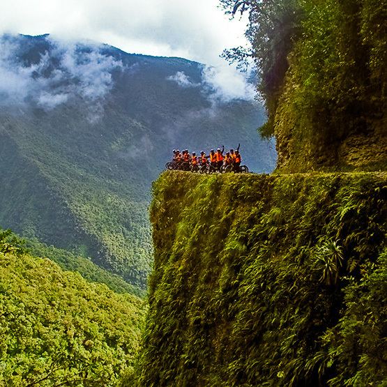
Accidente en el camino a los yungas bolivia
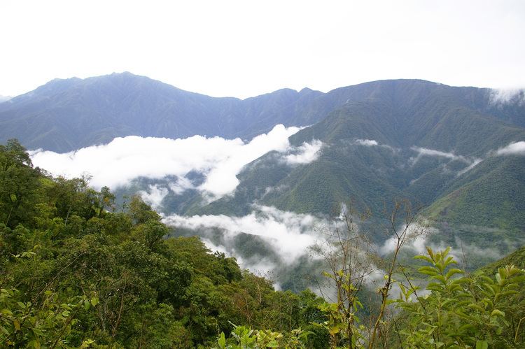
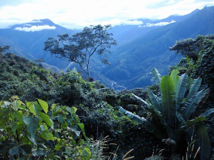
The Yungas (Aymara yunka warm or temperate Andes or earth, Quechua yunka warm area on the slopes of the Andes) is a narrow band of forest along the eastern slope of the Andes Mountains from Peru, Bolivia, and northern Argentina. It is a transitional zone between the Andean highlands and the eastern forests. Like the surrounding areas the Yungas belong to the Neotropic ecozone and climate is rainy, humid, and warm.
Contents
- Accidente en el camino a los yungas bolivia
- Carretera de la muerte yungas suri
- Setting
- World Wildlife ecoregions
- Climate
- Peruvian Yungas
- Sea Yunga
- Fluvial Yunga
- Flora and fauna
- Overview
- Human use
- References
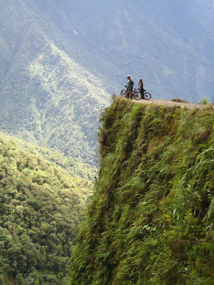
Carretera de la muerte yungas suri
Setting
The Yungas forests are extremely diverse, ranging from moist lowland forest to evergreen montane forest and cloud forests. The terrain, formed by valleys, fluvial mountain trails and streams, is extremely rugged and varied, contributing to the ecological diversity and richness. A complex mosaic of habitats occur with changing latitude as well as elevation. There are high levels of biodiversity and species endemism throughout the Yungas regions. Many of the forests are evergreen, and the South Andean Yungas contains what may be the last evergreen forests resulting from Quaternary glaciations.
World Wildlife ecoregions
The World Wide Fund for Nature has delineated three yungas ecoregions along the eastern side of the Andes:
Yungas are transitional zones between the Andean highlands and the eastern forests. The yungas forests are extremely diverse, ranging from moist lowland forest to evergreen montane forest and cloud forests. The terrain is extremely rugged and varied, contributing to the ecological diversity and richness. A complex mosaic of habitats occur with changing latitude as well as elevation. There are high levels of biodiversity and species endemism throughout the yungas regions. Many of the forests are evergreen, and the South Andean Yungas contains what may be the last evergreen forests resulting from Quaternary glaciations.
Climate
The average temperature is 22 °C. The climate is varied and ranges from a humid tropical to the cold of the Andes over 3,000 meters.
Peruvian Yungas
In Peru there is a difference between Yunga and Yungas. Yunga is considered a natural region on both sides of the Peruvian Andes, the western side towards the coast is called Sea Yunga, and the eastern side into the jungle is called Fluvial Yunga, both reach a height of 2,300 m.
Instead, Yungas is the ecoregion of rain forest and montane forest from 1.000 to 3.500 m, so it is limited to the eastern side of the Andes. This concept has a closer analogy with the Bolivian Yungas. This region is considered as the most endemic biodiversity of Peru.
Forest loss in the Peruvian Yungas has sharply accelerated since the 2000s, rising seven-fold between 2005 and late 2012, according to satellite analysis by Terra-i.
Sea Yunga
Sea Yunga, or Maritime Yunga, is found between 500 and 2,300 m and it is situated between the eastern part of the coastal strip and the western part of the Highlands. This subregion has a subtropical desert climate with little rainfall along the central and southern coast (drier as you go south). The average year round day temperature is 21 °C (70 °F) (max 33 °C min 8 °C). A mist-fed ecosystem called Lomas is found at scattered locations among hills near the Pacific Ocean at elevations up to 1,000 metres (3,300 ft).
The flora in the central Sea Yungas region is mainly composed by the lucuma and chirimoya trees, the casuarin and others.
Once you go north its climate becomes subtropical in the vicinity of La Libertad, Lambayeque and Piura. Day time temperatures average between 21 °C (70 °F) and 25 °C (77 °F) depending on latitude (max 40 °C min 15 °C).
As this area approaches the tropics, fauna differs from the rest of the coast, so that animals like the boas, larger reptiles and the famous white-winged guan (a bird species unique to this Peruvian ecoregion) occur here. Common trees in this area are the faique, the zapote, the zapayal, the barrigon and other thorny tropical savanna trees of the equatorial dry forests on the northern coast of Piura and Tumbes.
The cooler Pacific side is more vaguely characterized. The dry and cool Yunga Costal begins at 500 m above sea level. The Maritime Yunga begins dry, and it seems to follow ecotone on ecotone until reaching the Quechua region at the Pacific side.
Fluvial Yunga
Fluvial Yunga, that is between the 1,000 metres (3,300 ft) and 2,300 metres (7,500 ft), and is found on the eastern part of Peru. This sub-region has a subtropical climate with ample seasonal rains. The average temperature fluctuates between 20 °C and 25 °C depending on the altitude (max 35 °C, min 11 °C).
Concept:
The conce pt of the east side of the continental divide is straightfoward. 1,000 m above sea level it is 4.9 °C cooler, and the subtropical cloud forest (Fluvial Yunga) follows the tropical rainforest (Anti). The Tree line is at annual mean temperature of 10 °C at 3,500 m. In the middle, 2,300 m is the transition to temperate climate (Quechua). Between Tree line and the annual mean temperature of 7.5 °C, crops are possible and the region is named Suni.
Flora and fauna
The flora (subtropical cloud forest) of the Yunga region is mainly composed by the Peruvian pepper tree, the Furcraea, white cabuya (Furcraea andina), the pitahaya and the Peruvian torch cactus (Echinopsis peruviana). The coca leaf is established in this region as well as the uña de gato ("cat's claw", Uncaria tomentosa). The most attractive sites of this warm refreshing region are its many orchid forests and beautiful valleys. The fauna in the Yunga region is characterized by the long-tailed mockingbird, or chaucato.
Overview
Andean Continental Divide
Mountain Top:
Human use
In the early 20th century, the region was a major source for rubber and quinine. Now, coffee, citrus, and coca are important crops. People cultivate native plants like the canistel or eggfruit tree the lúcuma tree, the cherimoya or chirimoya, the guava or guayabo and the avocado or palta.
The Afro Bolivian community is concentrated here.
The Yungas Cocalera Revolution is based in the region. Its name derives from the one applied for the same mountain level by those who study the economic system of the prehispanic Andes.
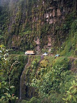
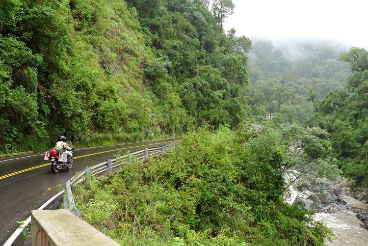
The Yungas also bear the most dangerous road in the world, called the "camino de la muerte," or Highway of Death.
Due to the mountainous terrain an entrepreneurial coca harvester created a network of zip lines that permit rapid travel from peak to peak by farmers, referred to locally as flying men or bird men, along with their harvests using zip line trollies.