
 | ||
Kurdistan region sulaymaniyah entrance 3 4 2016
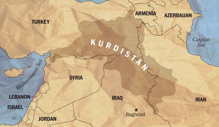
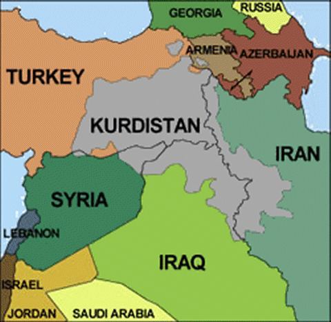
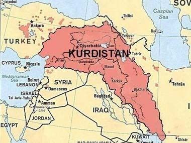
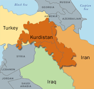
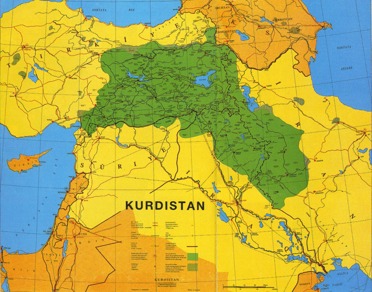
Kurdistan (/ˌkɜːrdɪˈstæn/ or /ˌkɜːrdɪˈstɑːn/) (Kurdish: [ˌkurdɪˈstan]; "Homeland of the Kurds" or "Land of the Kurds"; also formerly spelled Curdistan; ancient name: Corduene) or Greater Kurdistan, is a roughly defined geo-cultural region wherein the Kurdish people form a prominent majority population, and Kurdish culture, languages, and national identity have historically been based. Kurdistan roughly encompasses the northwestern Zagros and the eastern Taurus mountain ranges.
Contents
- Kurdistan region sulaymaniyah entrance 3 4 2016
- Ancient history
- Post classical history
- Modern history
- Turkey
- Syrian Civil War
- People
- Geography
- Subdivisions Upper and Lower Kurdistan
- Climate
- Forests
- Mountains
- Rivers
- Lakes
- Petroleum and mineral resources
- References
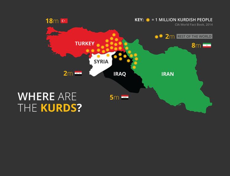
Contemporary use of the term refers to four parts of Kurdistan, which include southeastern Turkey (Northern Kurdistan), northern Syria (Rojava or Western Kurdistan), northern Iraq (Southern Kurdistan), and northwestern Iran (Eastern Kurdistan). Some Kurdish nationalist organizations seek to create an independent nation state consisting of some or all of these areas with a Kurdish majority, while others campaign for greater autonomy within the existing national boundaries.
Iraqi Kurdistan first gained autonomous status in a 1970 agreement with the Iraqi government, and its status was re-confirmed as an autonomous entity within the federal Iraqi republic in 2005. There is a province by the name Kurdistan in Iran; it is not self-ruled. Kurds fighting in the Syrian Civil War were able to take control of large sections of northern Syria as government forces, loyal to Bashar al-Assad, withdrew to fight elsewhere. Having established their own government, they called for autonomy in a federal Syria after the war.
Ancient history
Various groups, among them the Guti, Hurrians, Mannai (Mannaeans), and Armenians, lived in this region in antiquity. The original Mannaean homeland was situated east and south of the Lake Urmia, roughly centered around modern-day Mahabad. The region came under Persian rule during the reign of Cyrus the Great and Darius I.
The Kingdom of Corduene, which emerged from the declining Seleucid Empire, was located to the south and south-east of Lake Van between Persia and Mesopotamia and ruled northern Mesopotamia and southeastern Anatolia from 189 BC to AD 384 as vassals of the vying Parthian and Roman Empire. At its zenith, the Roman Empire ruled large Kurdish-inhabited areas, particularly the western and northern Kurdish areas in the Middle East. Corduene became a vassal state of the Roman Republic in 66 BC and remained allied with the Romans until AD 384. After 66 BC, it passed another 5 times between Rome and Persia. Corduene was situated to the east of Tigranocerta, that is, to the east and south of present-day Diyarbakır in south-eastern Turkey.
Some historians have correlated a connection between Corduene with the modern names of Kurds and Kurdistan; T. A. Sinclair dismissed this identification as false, while a common association is asserted in the Columbia Encyclopedia.
Some of the ancient districts of Kurdistan and their corresponding modern names:
- Corduene or Gordyene (Siirt, Bitlis and Şırnak)
- Sophene (Diyarbakır)
- Zabdicene or Bezabde (Gozarto d'Qardu or Jazirat Ibn or Cizre)
- Basenia (Bayazid)
- Moxoene (Muş)
- Nephercerta (Miyafarkin)
- Artemita (Van)
One of the earliest records of the phrase land of the Kurds is found in an Assyrian Christian document of late antiquity, describing the stories of Assyrian saints of the Middle East, such as Abdisho. When the Sasanian Marzban asked Mar Abdisho about his place of origin, he replied that according to his parents, they were originally from Hazza, a village in Assyria. However they were later driven out of Hazza by pagans, and settled in Tamanon, which according to Abdisho was in the land of the Kurds. Tamanon lies just north of the modern Iraq-Turkey border, while Hazza is 12 km southwest of modern Erbil. In another passage in the same document, the region of the Khabur River is also identified as land of the Kurds. According to Al-Muqaddasi and Yaqut al-Hamawi, Tamanon was located on the south-western or southern slopes of Mount Judi and south of Cizre.
Post-classical history
In the tenth and eleventh centuries, several Kurdish principalities emerged in the region: in the north the Shaddadids (951–1174) (in east Transcaucasia between the Kur and Araxes rivers) and the Rawadids (955–1221) (centered on Tabriz and which controlled all of Azarbaijan), in the east the Hasanwayhids (959–1015) (in Zagros between Shahrizor and Khuzistan) and the Annazids (990–1116) (centered in Hulwan) and in the west the Marwanids (990–1096) to the south of Diyarbakır and north of Jazira.
Kurdistan in the Middle Ages was a collection of semi-independent and independent states called emirates. It was nominally under indirect political or religious influence of Khalifs or Shahs. A comprehensive history of these states and their relationship with their neighbors is given in the text of Sharafnama, written by Prince Sharaf al-Din Bitlisi in 1597. The emirates included Baban, Soran, Badinan and Garmiyan in the south; Bakran, Bohtan (or Botan) and Badlis in the north, and Mukriyan and Ardalan in the east.
The earliest medieval attestation of the toponym Kurdistan is found in a 12th-century Armenian historical text by Matteos Urhayeci. He described a battle near Amid and Siverek in 1062 as to have taken place in Kurdistan. The second record occurs in the prayer from the colophon of an Armenian manuscript of the Gospels, written in 1200.
A later use of the term Kurdistan is found in Empire of Trebizond documents in 1336 and in Nuzhat-al-Qulub, written by Hamdollah Mostowfi in 1340.
Modern history
According to Sharafkhan Bitlisi in his Sharafnama, the boundaries of the Kurdish land begin at the Strait of Hormuz in the Persian Gulf and stretch on an even line to the end of Malatya and Marash. Evliya Çelebi, who traveled in Kurdistan between 1640 and 1655, mentioned different districts of Kurdistan including Erzurum, Van, Hakkari, Cizre, Imaddiya, Mosul, Shahrizor, Harir, Ardalan, Baghdad, Derne, Derteng, until Basra.
In the 16th century, after prolonged wars, Kurdish-inhabited areas were split between the Safavid and Ottoman empires. A major division of Kurdistan occurred in the aftermath of the Battle of Chaldiran in 1514, and was formalized in the 1639 Treaty of Zuhab. From then until the aftermath of World War I, Kurdish areas (including most of Mesopotamia, eastern Anatolia, and traditionally Kurdish northeastern Syria) were generally under Ottoman rule, apart from the century-long, intermittent Iranian occupation in the early modern to modern period, and the later reconquest and vast expansion by the Iranian military leader Nader Shah in the first half of the 18th century. After the collapse of the Ottoman Empire, the Allies contrived to split Kurdistan (as detailed in the ultimately unratified Treaty of Sèvres) among several countries, including Kurdistan, Armenia and others. However, the reconquest of these areas by the forces of Kemal Atatürk (and other pressing issues) caused the Allies to accept the renegotiated Treaty of Lausanne and the borders of the modern Republic of Turkey, leaving the Kurds without a self-ruled region. Other Kurdish areas were assigned to the new British and French mandated states of Iraq and Syria.
At the San Francisco Peace Conference of 1945, the Kurdish delegation proposed consideration of territory claimed by the Kurds, which encompassed an area extending from the Mediterranean shores near Adana to the shores of the Persian Gulf near Bushehr, and included the Lur inhabited areas of southern Zagros.
At the end of the First Gulf War, the Allies established a safe haven in northern Iraq. Amid the withdrawal of Iraqi forces from three northern provinces, Iraqi Kurdistan emerged in 1992 as an autonomous entity inside Iraq with its own local government and parliament.
A 2010 US report, written before the instability in Syria and Iraq that exists as of 2014, attested that "Kurdistan may exist by 2030". The weakening of the Iraqi state following the 2014 Northern Iraq offensive by the Islamic State of Iraq and the Levant has also presented an opportunity for independence for Iraqi Kurdistan, augmented by Turkey's move towards acceptance of such a state although it opposes moves toward Kurdish autonomy in Turkey and Syria.
Turkey
The incorporation into Turkey of the Kurdish-inhabited regions of eastern Anatolia was opposed by many Kurds, and has resulted in a long-running separatist conflict in which thousands of lives have been lost. The region saw several major Kurdish rebellions, including the Koçgiri rebellion of 1920 under the Ottomans, then successive insurrection under the Turkish state – including the 1924 Sheikh Said rebellion, the Republic of Ararat in 1927, and the 1937 Dersim rebellion. All were forcefully put down by the authorities. The region was declared a closed military area from which foreigners were banned between 1925 and 1965.
In an attempt to deny their existence, the Turkish government categorized Kurds as "Mountain Turks" until 1991. The words "Kurds", "Kurdistan", or "Kurdish" were officially banned by the Turkish government. Following the military coup of 1980, the Kurdish language was officially prohibited in public and private life. Many people who spoke, published, or sang in Kurdish were arrested and imprisoned. Throughout the 1990s and early 2000s, political parties that represented Kurdish interests were banned.
In 1983, the Kurdish provinces were placed under martial law in response to the activities of the militant separatist organization, Kurdistan Workers' Party (PKK). A guerrilla war took place through the 1980s and 1990s in which much of the countryside was evacuated, thousands of Kurdish-populated villages were destroyed, and numerous extrajudicial summary executions were carried out by both sides. Many villages were reportedly set on fire or destroyed. Food embargoes were placed on Kurdish populated villages and towns. More than 20,000 Kurds were killed in the violence and hundreds of thousands more were forced to leave their homes.
Turkey has historically feared that a Kurdish state in Northern Iraq would encourage and support Kurdish separatists in the adjacent Turkish provinces, and have therefore historically strongly opposed Kurdish independence in Iraq. However, following the chaos in Iraq after the US invasion, Turkey has increasingly worked with the de facto autonomous Kurds in Iraq.
Syrian Civil War
The successful 2014 Northern Iraq offensive by the Islamic State of Iraq and the Levant, with the resultant weakening of the ability of the Iraqi state to project power, also presented a "golden opportunity" for the Kurds to increase their independence and possibly declare an independent Kurdish state. The Islamic State in Iraq and the Levant, who took more than 80 Turkish persons captive in Mosul during their offensive, is an enemy of Turkey, making Kurdistan useful for Turkey as a buffer state. On 28 June 2014 Hüseyin Çelik, a spokesman for the ruling AK party, made comments to the Financial Times indicating Turkey's readiness to accept an independent Kurdistan in northern Iraq. Various sources have reported that Al-Nusra has issued a fatwā calling for Kurdish women and children in Syria to be killed, and the fighting in Syria has led tens of thousands of refugees to flee to Iraq's Kurdistan region. As of 2015, Turkey is actively supporting the Al-Nusra.
People
The Kurds are a people of Indo-European origin. They speak an Iranian language known as Kurdish, and comprise the majority of the population of the region – however, included therein are Arab, Armenian, Assyrian/Aramean/Syriac, Azerbaijani, Jewish, Ossetian, Persian, and Turkish communities. Most inhabitants are Muslim, but adherents to other religions are present as well – including Yarsanism, which is an ethnically Kurdish religion, Yazidis, Alevis, Christians, and in the past, Jews most of whom immigrated to Israel.
Geography
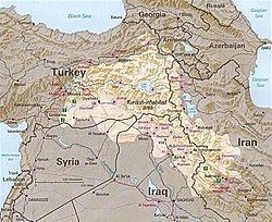
According to the Encyclopædia Britannica, Kurdistan covers about 190,000 km², and its chief towns are Diyarbakır (Amed), Bitlis (Bedlîs) and Van (Wan) in Turkey, Erbil (Hewlêr) and Slemani in Iraq, and Kermanshah (Kirmanşan), Sanandaj (Sine), Ilam and Mahabad (Mehabad) in Iran. According to the Encyclopaedia of Islam, Kurdistan covers around 190,000 km² in Turkey, 125,000 km² in Iran, 65,000 km² in Iraq, and 12,000 km² in Syria, with a total area of approximately 392,000 km².
Iraqi Kurdistan is divided into six governorates, three of which (and parts of others) are under the control of the Kurdistan Regional Government. Iranian Kurdistan encompasses Kurdistan Province and the greater parts of West Azerbaijan, Kermanshah, and Īlām provinces. Syrian Kurdistan (Kurdish: Rojavayê Kurdistanê) is located primarily in northern Syria, and covers the province of Al Hasakah and northern Raqqa Governorate, northern Aleppo Governorate and also Jabal al-Akrad (Mountain of the Kurds) region. The major cities in this region are Qamishli (Kurdish: Qamişlo) and Al Hasakah (Kurdish: Hasakah).
Turkish Kurdistan encompasses a large area of Eastern Anatolia Region and southeastern Anatolia of Turkey and it is home to an estimated 15 to 20 million Kurds.
Subdivisions (Upper and Lower Kurdistan)
In A Dictionary of Scripture Geography (published 1846), John Miles describes Upper and Lower Kurdistan as following:
Modern Curdistan is of much greater extent than the ancient Assyria, and is composed of two parts the Upper and Lower. In the former is the province of Ardelan, the ancient Arropachatis, now nominally a part of Irak Ajami, and belonging to the north west division called Al Jobal. It contains five others namely, Betlis, the ancient Carduchia, lying to the south and south west of the lake Van. East and south east of Betlis is the principality of Julamerick, south west of it is the principality of Amadia. the fourth is Jeezera ul Omar, a city on an island in the Tigris, and corresponding to the ancient Bezabde. the fifth and largest is Kara Djiolan, with a capital of the same name. The pashalics of Kirkook and Solimania also comprise part of Upper Curdistan. Lower Curdistan comprises all the level tract to the east of the Tigris, and the minor ranges immediately bounding the plains and reaching thence to the foot of the great range, which may justly be denominated the Alps of western Asia.
The northern, northwestern and northeastern parts of Kurdistan are referred to as upper Kurdistan, and includes the areas from west of Amed to lake Urmia.
The lowlands of southern Kurdistan are called lower Kurdistan. The main cities in this area are Kirkuk and Arbil.
Climate
Much of the region is typified by an extreme continental climate – hot in the summer, bitterly cold in the winter. Despite this, much of the region is fertile and has historically exported grain and livestock. Precipitation varies between 200 and 400 mm a year in the plains, and between 700 and 3,000 mm a year on the high plateau between mountain chains. The climate is dominated by mountains in the zone along the border with Iran and Turkey, with dry summers and cold, snowy winters or wet springs, while to the south, it progressively transitions towards semi-arid and desert zones. The northern mountainous regions along the border with Iran and Turkey receive heavy snowfall.
Forests
Kurdistan is one of the most mountainous regions in the world with a cold climate receiving annual precipitation adequate to sustain temperate forests and shrubs. Mountain chains harbor pastures and forested valleys, totaling approximately 16 million hectares (160,000 km²), including firs and countryside is mostly oaks, conifers, platanus, willow, poplar and olive. Also the Mediterranean region known as west Kurdistan has olive trees. Kurdistan's climatic conditions are due to the northern mountainous topography producing the steppe and forest vegetation in the area. The region north of the mountainous region on the border with Iran and Turkey features meadow grasses and such wild trees as poplar, willow and oak, hawthorn, Cherry plum, rose hips, mountain apple, pear, mountain ash, and olive. The desert in the south, by contrast, has such species as palm trees and date palm.
Mountains
Mountains are important geographical and symbolic features of Kurdish life, as evidenced by the saying "Kurds have no friends but the mountains." Mountains are regarded as sacred by the Kurds. Included in the region are Mount Judi and Ararat (both prominent in Kurdish folklore), Zagros, Qandil, Shingal, Mount Abdulaziz, Kurd Mountains, Jabal al-Akrad, Shaho, Gabar, Hamrin, and Nisir.
Rivers
The plateaus and mountains of Kurdistan, which are characterized by heavy rain and snow fall, act as a water reservoir for the Near and Middle East, forming the source of the Tigris and Euphrates rivers, as well as other numerous smaller rivers, such as the Khabur, Tharthar, Ceyhan, Araxes, Kura, Sefidrud, Karkha, and Hezil. Among rivers of historical importance to Kurds are the Murat (Arasān) and Buhtān rivers in Turkey; the Peshkhābur, the Little Zab, the Great Zab, and the Diyala in Iraq; and the Jaghatu (Zarrinarud), the Tātā'u (Siminarud), the Zohāb (Zahāb), and the Gāmāsiyāb in Iran.
These rivers, which flow from heights of three to four thousand meters above sea level, are significant both as water sources and for the production of energy. Iraq and Syria dammed many of these rivers and their tributaries, and Turkey has an extensive dam system under construction as part of the GAP (Southeast Anatolia Project); though incomplete, the GAP already supplies a significant proportion of Turkey's electrical energy needs. Due to the extraordinary archaeological richness of the region, almost any dam impacts historic sites.
Lakes
Kurdistan extends to Lake Urmia in Iran on the east. The region includes Lake Van, the largest body of water in Turkey; the only lake in the Middle East with a larger surface is Lake Urmia – though not nearly as deep as Lake Van, which has a much larger volume. Urmia, Van, as well as Zarivar Lake west of Marivan, and Lake Dukan near the city of Sulaymaniyah, are frequented by tourists.
Petroleum and mineral resources
KRG-controlled parts of Iraqi Kurdistan are estimated to contain around 45 billion barrels (7.2×10^9 m3) of oil, making it the sixth largest reserve in the world. Extraction of these reserves began in 2007.
Al-Hasakah province, also known as Jazira region, has geopolitical importance of oil and is suitable for agricultural lands.
In November 2011, Exxon challenged the Iraqi central government's authority with the signing of oil and gas contracts for exploration rights to six parcels of land in Kurdistan, including one contract in the disputed territories, just east of the Kirkuk mega-field. This act caused Baghdad to threaten to revoke Exxon's contract in its southern fields, most notably the West-Qurna Phase 1 project. Exxon responded by announcing its intention to leave the West-Qurna project.
As of July 2007, the Kurdish government solicited foreign companies to invest in 40 new oil sites, with the hope of increasing regional oil production over the following 5 years by a factor of five, to about 1 million barrels per day (160,000 m3/d). Gas and associated gas reserves are in excess of 2,800 km3 (100×10^12 cu ft). Notable companies active in Kurdistan include Exxon, Total, Chevron, Talisman Energy, Genel Energy, Hunt Oil, Gulf Keystone Petroleum, and Marathon Oil.
Other mineral resources that exist in significant quantities in the region include coal, copper, gold, iron, limestone (which is used to produce cement), marble, and zinc. The world's largest deposit of rock sulfur is located just southwest of Erbil (Hewlêr).
In July 2012, Turkey and the Kurdistan Regional Government signed an agreement by which Turkey will supply the KRG with refined petroleum products in exchange for crude oil. Crude deliveries are expected to occur on a regular basis.