
Isolation 124 kilometres (77 mi) First ascent 25 May 1955 | Elevation 8,586 m Prominence 3,922 m | |
 | ||
Similar Makalu, Lhotse, Mount Everest, Cho Oyu, Manaslu | ||
Kangchenjunga peak five treasures of snow
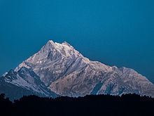
Kangchenjunga (Nepali: कञ्चनजङ्घा; Hindi: कंचनजंघा; Sikkimese: ཁང་ཅེན་ཛོཾག་), also spelled Kanchenjunga, is the third highest mountain in the world, and lies partly in Nepal and partly in Sikkim, India. It rises with an elevation of 8,586 m (28,169 ft) in a section of the Himalayas called Kangchenjunga Himal that is limited in the west by the Tamur River, in the north by the Lhonak Chu and Jongsang La, and in the east by the Teesta River.
Contents
- Kangchenjunga peak five treasures of snow
- Map of Kangchenjunga
- Names
- Protected areas
- Geography
- Climbing routes
- Early reconnaissances and attempts
- First ascent
- Other notable ascents
- Tourism
- In myth
- In literature
- References
Map of Kangchenjunga
Mount Kangchenjunga lies about 125 km (78 mi) east-south-east of Mount Everest. It is the second highest mountain of the Himalayas. Three of the five peaks – Main, Central and South – are on the border between North Sikkim and Nepal. Two peaks are in Nepal's Taplejung District.
Kangchenjunga Main is the highest mountain in India, and the easternmost of the mountains higher than 8,000 m (26,000 ft). It is called Five Treasures of Snow after its five high peaks, and has always been worshipped by the people of Darjeeling and Sikkim.
Until 1852, Kangchenjunga was assumed to be the highest mountain in the world, but calculations based on various readings and measurements made by the Great Trigonometrical Survey of India in 1849 came to the conclusion that Mount Everest, known as Peak XV at the time, was the highest. Allowing for further verification of all calculations, it was officially announced in 1856 that Kangchenjunga is the third highest mountain in the world.
Kangchenjunga was first climbed on 25 May 1955 by Joe Brown and George Band, who were part of a British expedition. They stopped short of the summit as per the promise given to the Chogyal that the top of the mountain would remain inviolate. Every climber or climbing group that has reached the summit has followed this tradition. Other members of this expedition included John Angelo Jackson and Tom Mackinon.
Names
Kangchenjunga is the official spelling adopted by Douglas Freshfield, Alexander Mitchell Kellas, and the Royal Geographical Society that gives the best indication of the Tibetan pronunciation. Freshfield referred to the spelling used by the Indian Government since the late 19th century. There are a number of alternative spellings including Kangchendzönga, Khangchendzonga, and Kanchenjunga.
The brothers Hermann, Adolf and Robert Schlagintweit explained the local name Kanchinjínga (Tibetan: གངས་ཆེན་མཛོད་ལྔ་, Wylie: gangs chen mdzod lnga, Sikkimese IPA: [k̀ʱɐŋt͡ɕʰẽd͡zø̃ŋɐ]) meaning "The five treasures of the high snow" as originating from the Tibetan word (following IPA given in Sikkimese) gangs /k̀ʱɐŋ/ meaning "snow, ice"; chen /t͡ɕʰẽ/ meaning "great"; mdzod /d͡zø/ meaning "treasure"; lnga /̃ŋɐ/ meaning "five". It means "The Five repositories or ledges of great snow" and is physically descriptive of its five peaks. Local Lhopo people believe that the treasures are hidden but reveal to the devout when the world is in peril; the treasures comprise salt, gold, turquoise and precious stones, sacred scriptures, invincible armor or ammunition, grain and medicine.
Kangchenjunga's name in the Limbu language is Senjelungma or Seseylungma, and is believed to be an abode of the omnipotent goddess Yuma Sammang.
Protected areas
The Kangchenjunga landscape is a complex of three distinct ecoregions: the eastern Himalayan broad-leaved and coniferous forests, the Eastern Himalayan alpine shrub and meadows and the Terai-Duar savanna and grasslands. The Kangchenjunga transboundary landscape is shared by Bhutan, China, India and Nepal, and comprises 14 protected areas with a total of 6,032 km2 (2,329 sq mi):
These protected areas are habitats for many globally significant plant species such as rhododendrons and orchids and many endangered flagship species such as snow leopard, Asian black bear, red panda, white-bellied musk deer, blood pheasant and chestnut-breasted partridge.
Geography
The Kangchenjunga Himal section of the Himalayas lies both in Nepal and India, and encompasses 16 peaks over 7,000 m (23,000 ft). In the north, it is limited by the Lhonak Chu, Goma Chu and Jongsang La, and in the east by the Teesta River. The western limit runs from the Jongsang La down the Gingsang and Kangchenjunga glaciers and the rivers of Ghunsa and Tamur. Kanchenjunga rises about 20 km (12 mi) south of the general alignment of the Great Himalayan range about 125 km (78 mi) east-south-east of Mount Everest as the crow flies. South of the southern face of Kanchenjunga runs the 3,000–3,500 m (9,800–11,500 ft) high Singalila Ridge that separates Sikkim from Nepal and northern West Bengal.
Kangchenjunga and its satellite peaks form a huge mountain massif. The massif's five highest peaks are listed in the following table.
The main ridge of the massif runs from north-north-east to south-south-west and forms a watershed to several rivers. Together with ridges running roughly from east to west they form a giant cross. These ridges contain a host of peaks between 6,000 and 8,586 m (19,685 and 28,169 ft). The northern section includes Yalung Kang, Kangchenjunga Central and South, Kangbachen, Kirat Chuli and Gimmigela Chuli, and runs up to the Jongsang La. The eastern ridge in Sikkim includes Siniolchu. The southern section runs along the Nepal-Sikkim border and includes Kabru I to III. This ridge extends southwards to the Singalila Ridge. The western ridge culminates in the Kumbhakarna, also known as Jannu.
Four main glaciers radiate from the peak, pointing roughly to the north-east, south-east, north-west and south-west. The Zemu glacier in the north-east and the Talung glacier in the south-east drain to the Teesta River; the Yalung glacier in the south-west and the Kangchen glacier in the north-west drain to the Arun and Kosi rivers. The glaciers spread over the area above approximately 5,000 m (16,000 ft), and the glacialized area covers about 314 km2 (121 sq mi) in total. There are 120 glaciers in the Kanchenjunga Himal, of which 17 are debris-covered. Between 1958 and 1992, more than half of 57 examined glaciers had retreated, possibly due to rising of air temperature.
Kangchenjunga Main is the highest elevation of the Brahmaputra River basin, which forms part of the southeast Asian monsoon regime and is among the globally largest river basins. Kangchenjunga is one of six peaks above 8,000 m (26,000 ft) located in the basin of the Koshi river, which is among the largest tributaries of the Ganges. The Kangchenjunga massif forms also part of the Ganges Basin.
Although it is the third highest peak in the world, Kangchenjunga is only ranked 29th by topographic prominence, a measure of a mountain's independent stature. The key col for Kangchenjunga lies at a height of 4,664 metres (15,302 ft), along the watershed boundary between Arun and Brahmaputra rivers in Tibet. It is however, the 4th most prominent peak in the Himalaya, after Everest, and the western and eastern anchors of the Himalaya, Nanga Parbat and Namcha Barwa, respectively.
Climbing routes
There are four climbing routes to reach the summit of Kangchenjunga, three of which are in Nepal from the southwest, northwest and northeast, and one from northeastern Sikkim in India. To date, the northeastern route from Sikkim has been successfully used only three times. It is worth noting that the Indian government has banned expeditions to Kanchenjunga and therefore, this route is closed since 2000.
Early reconnaissances and attempts
First ascent
In 1955, Joe Brown and George Band made the first ascent on 25 May, followed by Norman Hardie and Tony Streather on 26 May. The full team also included John Clegg (team doctor), Charles Evans (team leader), John Angelo Jackson, Neil Mather, and Tom Mackinnon.
The ascent proved that Aleister Crowley's 1905 route (also investigated by the 1954 reconnaissance) was viable. The route starts on the Yalung Glacier to the southwest of the peak, and climbs the Yalung Face, which is 3,000 metres (10,000 ft) high. The main feature of this face is the "Great Shelf", a large sloping plateau at around 7,500 metres (24,600 ft), covered by a hanging glacier. The route is almost entirely on snow, glacier, and one icefall; the summit ridge itself can involve a small amount of travel on rock. The first ascent expedition made six camps above their base camp, two below the Shelf, two on it, and two above it. They started on 18 April, and everyone was back to base camp by 28 May.
Other notable ascents
Despite improved climbing gear the fatality rate of climbers attempting to summit Kanchenjunga is high. Since the 1990s, more than 20% of people died while climbing Kanchenjunga's main peak.
Tourism
Some of the most famous views of Kangchenjunga are from the hill station of Darjeeling and Antu Dada of Ilam, Nepal. The Darjeeling War Memorial is among the most visited places from which Kangchenjunga is observed. On a clear day it presents an image not so much of a mountain but of a white wall hanging from the sky. The people of Sikkim revere Kangchenjunga as a sacred mountain. Permission to climb the mountain from the Indian side is rarely given.
Due to its remote location in Nepal and the difficulty involved in accessing it from India, the Kangchenjunga region is not much explored by trekkers. It has, therefore, retained much of its pristine beauty. In Sikkim too, trekking into the Kangchenjunga region has just recently been permitted. The Goecha La trek is gaining popularity amongst tourists. It goes to the Goecha La Pass, located right in front of the huge southeast face of Kangchenjunga. Another trek to Green Lake Basin has recently been opened for trekking. This trek goes to the Northeast side of Kangchenjunga along the famous Zemu Glacier.
In myth
The area around Kangchenjunga is said to be home to a mountain deity, called Dzö-nga or "Kangchenjunga Demon", a type of yeti or rakshasa. A British geological expedition in 1925 spotted a bipedal creature which they asked the locals about, who referred to it as the "Kangchenjunga Demon".
For generations, there have been legends recounted by the inhabitants of the areas surrounding Mount Kanchenjunga, both in Sikkim and in Nepal, that there is a valley of immortality hidden on its slopes. These stories are well known to both the original inhabitants of the area, the Lepcha people, and those of the Tibetan Buddhist cultural tradition. In Tibetan, this valley is known as Beyul Demoshong. In 1962 a Tibetan Lama by the name of Tulshuk Lingpa led over 300 followers into the high snow slopes of Kanchenjunga to ‘open the way’ to Beyul Demoshong. The story of this expedition is recounted in the 2011 book A Step Away from Paradise.