
Elevation 7,350 m Prominence 432 m | Easiest route glacier/snow/ice climb First ascent 1994 | |
 | ||
First ascenders Taroh Tanigawa, Koji Nagakubo, Yuichi Yoshida Similar Lover's Leap, Kangchenjunga, Kirat Chuli, Jongsong Peak, Ngadi Chuli | ||
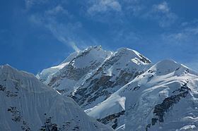
Gimmigela Chuli, or The Twins, is a mountain in the Himalayas, located on the border between Taplejung, Mechi, Nepal and Sikkim, India. It has an elevation of 7,350 m (24,110 ft) above sea level and is situated approximately 4.2 km (2.6 mi) NNE from Kangchenjunga, the third highest peak on Earth.
Contents
Map of Gimmigela Chuli, Lelep 57500, Nepal
The mountain has a subpeak, Gimmigela Chuli II (elevation = 7,005 metres; prominence = 185m). This subpeak, sometimes referred to as "Gimmigela's Sister", lies entirely within India. Together the two peaks, Gimmigela I and Gimmigela II, are known as "The Twins".
Climbing history
An attempt on the summit on 18 October 1994, ended with the death of Masanori Sato, the leader of a Japanese expedition. The team had achieved the first ascent of Gimmigela II and were on the summit ridge which connects the two peaks in an attempt to summit Gimmigela I (main) when Sato fell 35 meters into a hidden crevasse. Despite the efforts of the other team members, his body was not recovered and the expedition was terminated.
One year later on 16 October 1995, Taroh Tanigawa, Koji Nagakubo and Yuichi Yoshida, members of the failed attempt in 1994, achieved the first ascent of Gimmigela I.