
Population 107,197 (2001) Language spoken Nepali Area 10.57 km2 | State District Darjeeling | |
Points of interest Tiger Hill - Darjeeling, Padmaja Naidu Himalayan Zoological Park, Batasia Loop, Peace Pagoda - Darjeeling, Darjeeling Himalayan Railway Colleges and Universities Southfield College, Darjeeling Government College, St Josephs College, Salesian College - Darjeeling | ||
Darjeeling (Nepali : ?????????? ) is a town in the Indian state of West Bengal. It is located in the Mahabharat Range or Lesser Himalaya at an elevation of 7,100 ft (2,164.1 m). It is noted for its tea industry and the Darjeeling Himalayan Railway, a UNESCO World Heritage Site. Darjeeling is the headquarters of Darjeeling district which has a partially autonomous status within the state of West Bengal.
Contents
- Map of Darjeeling
- Darjeeling india travel guide and attractions
- Tourist places attractions to visit in darjeeling by globalvisiontours com
- History
- Geography
- Economy
- Culture
- Comforting motherly food at darjeeling restaurant india
- References
Map of Darjeeling
The development of the town dates back to the mid-19th century, when the colonial British administration set up a sanatorium and a military depot. Subsequently, extensive tea plantations were established in the region, and tea growers developed hybrids of black tea and created new fermentation techniques. The resultant distinctive Darjeeling tea is internationally recognized and ranks among the most popular of the black teas.
Darjeeling india travel guide and attractions
The Darjeeling Himalayan Railway connects the town with the plains and has one of the few steam locomotives still in service in India.
Tourist places & attractions to visit in darjeeling by globalvisiontours com
Darjeeling has several British-style public schools, which attract students from India and neighbouring countries. The varied culture of the town reflects its diverse demographic milieu consisting of Nepalis, Bhutia, Lepcha and other mainland Indian ethno-linguistic groups. Darjeeling, with its neighboring town of Kalimpong, was a center of the Gorkhaland movement (Separate State demand within India) in the 1980s. The towns fragile ecology has been threatened by a rising demand for environmental resources, stemming from growing tourist traffic and poorly planned urbanization.
History
The history of Darjeeling is intertwined with that of Sikkim, Nepal, British India and Bhutan. Until the early 19th century, the hilly area around Darjeeling was controlled by the kingdom of Sikkim, while the plains around Siliguri were intermittently occupied by the Kingdom of Nepal, with settlement consisting of a few villages of Lepcha and Kirati people. The Chogyal of Sikkim had been engaged in unsuccessful warfare against the Gorkhas of Nepal. From 1780, the Gorkhas made several attempts to capture the entire region of Darjeeling. By the beginning of 19th century, they had overrun Sikkim as far eastward as the Teesta River and had conquered and annexed the Terai. In the meantime, the British were engaged in preventing the Gorkhas from overrunning the whole of the northern frontier. The Anglo-Gorkha war broke out in 1814, which resulted in the defeat of the Gorkhas and subsequently led to the signing of the Sugauli Treaty in 1815. According to the treaty, Nepal had to cede all those territories which the Gorkhas had annexed from the Chogyal of Sikkim to the British East India Company (i.e. the area between Mechi River and Teesta River). Later in 1817, through the Treaty of Titalia, the British East India Company reinstated the Chogyal of Sikkim, restored all the tracts of land between the Mechi River and the Teesta River to the Chogyal of Sikkim and guaranteed his sovereignty.
In 1828, a delegation of the British East India Company (BEIC) officials on its way to the Nepal-Sikkim border stayed in Darjeeling and decided that the region was a suitable site for a sanatorium for British soldiers. The company negotiated a lease of the area west of the Mahananda River from the Chogyal of Sikkim in 1835. In 1849, the BEIC director Arthur Campbell and the explorer and botanist Joseph Dalton Hooker were imprisoned in the region by the Sikkim Chogyal. The BEIC sent a force to free them. Continued friction between the BEIC and the Sikkim authorities resulted in the annexation of 640 square miles (1,700 km2) of territory by the British in 1850. In 1864, the Bhutanese rulers and the British signed the Treaty of Sinchula that ceded the passes leading through the hills and Kalimpong to the British. Further discord between Sikkim and the British resulted in a war, culminating in the signing of a treaty and the annexation by the British of the area east of the Teesta River in 1865. By 1866, Darjeeling district had assumed its current shape and size, covering an area of 1,234 square miles (3,200 km2).
During the British Raj, Darjeelings temperate climate led to its development as a hill station for British residents seeking to escape the summer heat of the plains. The development of Darjeeling as a sanatorium and health resort proceeded briskly. Arthur Campbell, a surgeon with the Company, and Lieutenant Robert Napier were responsible for establishing a hill station there. Campbells efforts to develop the station, attract immigrants to cultivate the slopes and stimulate trade resulted in a hundredfold increase in the population of Darjeeling between 1835 and 1849. The first road connecting the town with the plains was constructed between 1839 and 1842. In 1848, a military depot was set up for British soldiers, and the town became a municipality in 1850. Commercial cultivation of tea in the district began in 1856, and induced a number of British planters to settle there. Darjeeling became the formal summer capital of the Bengal Presidency after 1864. Scottish missionaries undertook the construction of schools and welfare centres for the British residents, laying the foundation for Darjeelings notability as a centre of education. The opening of the Darjeeling Himalayan Railway in 1881 further hastened the development of the region. In 1899, Darjeeling was rocked by major landslides that caused severe damage to the town and the native population.
Under British rule, the Darjeeling area was initially a "Non-Regulation District", a scheme of administration applicable to economically less advanced districts in the British Raj; acts and regulations of the British Raj did not automatically apply to the district in line with rest of the country. In 1919, the area was declared a "backward tract". During the Indian independence movement, the Non-cooperation Movement spread through the tea estates of Darjeeling. There was also a failed assassination attempt by revolutionaries on Sir John Anderson, the Governor of Bengal in 1934. Subsequently, during the 1940s, Communist activists continued the nationalist movement against the British by mobilising the plantation workers and the peasants of the district.
Socio-economic problems of the region that had not been addressed during British rule continued to linger and were reflected in a representation made to the Constituent Assembly of India in 1947, which highlighted the issues of regional autonomy and Nepali nationality in Darjeeling and adjacent areas. After the independence of India in 1947, Darjeeling was merged with the state of West Bengal. A separate district of Darjeeling was established consisting of the hill towns of Darjeeling, Kurseong, Kalimpong and some parts of the Terai region. While the hill population comprised mainly ethnic Nepalis, the plains harboured a large ethnic Bengali population who were refugees from the Partition of India. A cautious and non-receptive response by the West Bengal government to most demands of the ethnic Nepali population led to increased calls, in the 1950s and 1960s, for Darjeelings autonomy and for the recognition of the Nepali language; the state government acceded to the latter demand in 1961.
The creation of a new state of Sikkim in 1975, along with the reluctance of the Government of India to recognise Nepali as an official language under the Constitution of India, brought the issue of a separate state of Gorkhaland to the forefront. Agitation for a separate state continued through the 1980s, included violent protests during the 1986–88 period. The agitation ceased only after an agreement between the government and the Gorkha National Liberation Front (GNLF), resulting in the establishment of an elected body in 1988 called the Darjeeling Gorkha Hill Council (DGHC), which received autonomy to govern the district. Though Darjeeling became peaceful, the issue of a separate state lingered, fuelled in part by the lack of comprehensive economic development in the region even after the formation of the DGHC. New protests erupted in 2008–09, but both the Union and State governments rejected Gorkha Janmukti Morchas (GJM) demand for a separate state. In July 2011, a pact was signed between GJM, the Government of West Bengal and the Government of India which includes the formation of a new autonomous, elected Gorkhaland Territorial Administration (GTA), a hill council endowed with more powers than its predecessor Darjeeling Gorkha Hill Council.
Geography
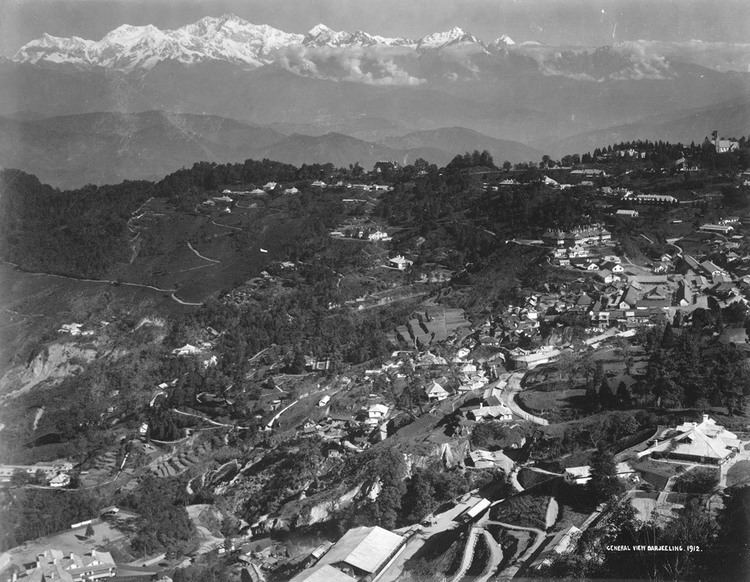
Darjeeling is the main town of the Sadar subdivision and also the headquarters of the district. It is located at an elevation of 7,100 ft (2,200 m) in the Darjeeling Himalayan hill region on the Darjeeling-Jalapahar range that originates in the south from Ghum. The range is Y-shaped with the base resting at Katapahar and Jalapahar and two arms diverging north of the Observatory Hill. The north-eastern arm dips suddenly and ends in the Lebong spur, while the north-western arm passes through North Point and ends in the valley near Tukver Tea Estate. The hills are nestled within higher peaks and the snow-clad Himalayan ranges tower over the town in the distance. Kanchenjunga, the worlds third-highest peak, 8,598 m (28,209 ft) high, is the most prominent mountain visible. In days clear of clouds, Nepals Mount Everest, 29,035 ft (8,850 m) high, can be seen.
The hills of Darjeeling are part of the Mahabharat Range or Lesser Himalaya. The soil is chiefly composed of sandstone and conglomerate formations, which are the solidified and upheaved detritus of the great range of Himalaya. However, the soil is often poorly consolidated (the permeable sediments of the region do not retain water between rains) and is not considered suitable for agriculture. The area has steep slopes and loose topsoil, leading to frequent landslides during the monsoons. According to the Bureau of Indian Standards, the town falls under seismic zone-IV, (on a scale of I to V, in order of increasing proneness to earthquakes) near the convergent boundary of the Indian and the Eurasian tectonic plates and is subject to frequent earthquakes.
Economy
The two most significant contributors to Darjeelings economy are tourism and the tea industry. Darjeeling tea, due to the unique agro-climatic conditions of Darjeeling, has a distinctive natural flavour, is internationally reputed and recognised as a geographical indicator. Darjeeling produces 7% of Indias tea output, approximately 9,000,000 kilograms (20,000,000 lb) every year. The tea industry has faced competition in recent years from tea produced in other parts of India as well as other countries like Nepal. Widespread concerns about labour disputes, worker layoffs and closing of estates have affected investment and production. Several tea estates are being run on a workers cooperative model, while others are being planned for conversion into tourist resorts. More than 60% of workers in the tea gardens are women. Besides tea, the most widely cultivated crops include maize, millets, paddy, cardamom, potato and ginger.
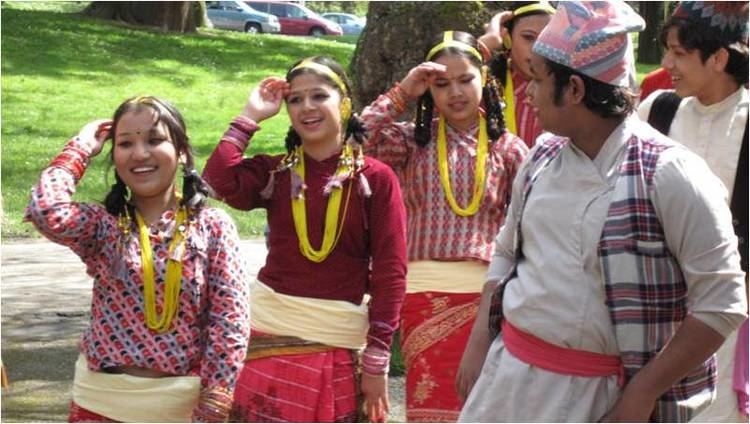
Culture
Apart from the major religious festivals of Dashain (Durga puja), Tihar (Diwali) and Christmas the diverse ethnic populace of the town celebrates several local festivals. The Lepchas and Bhutias celebrate new year in January, while Tibetans celebrate their new year, Losar, in February–March. The birthday of the Buddha is celebrated in mid-June with processions. Darjeeling Carnival, initiated by a civil society movement known as The Darjeeling Initiative, is a ten-day carnival held every year during the winter with portrayal of the Darjeeling Hills musical and cultural heritage as its central theme.
A popular food in Darjeeling is the Nepalese and Tibetan momo, a steamed dumpling containing meat cooked in a doughy wrapping and served with clear soup and achar. A form of Tibetan noodle called thukpa, served in soup form is also popular. Other commonly eaten dishes include alu dum, a potato preparation, and shaphalay, Tibetan bread stuffed with meat. Fermented foods and beverages are consumed by a large percentage of the population. Fermented foods include preparations of soybean, bamboo shoots, milk and Sel roti, which is made from rice. Tea is the most popular beverage, the Tibetan version is also drunk. Alcoholic beverages include Tongba, Jnaard and Chhaang, variations of a local beer made from fermenting finger millet.
Colonial architecture characterises many buildings in Darjeeling, exemplified by several mock Tudor residences, Gothic churches, the Raj Bhawan, Planters Club and various educational institutions. Buddhist monasteries showcase the pagoda style architecture. Darjeeling is regarded as a centre of music and a niche for musicians and music admirers. Singing and playing musical instruments is a common pastime among the resident population, who take pride in the traditions and role of music in cultural life.
Darjeeling also has a Peace Pagoda built in 1992 by the Japanese Buddhist organisation Nipponzan Myohoji.