
Length 352.4 km | ||
 | ||
Counties | ||
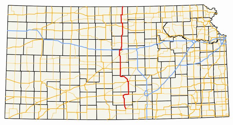
K-14 is a north–south state highway which runs most of the length of the U.S. state of Kansas. The highway runs through the central part of the state.
Contents
Map of KS-14, Kansas, USA
Route description
K-14 begins on its southern end at US-160 in the town of Harper in Harper County. From there, it travels north into Kingman County, crossing the Chikaskia River near the community of Rago. K-14 continues north to Kingman, where it crosses the South Fork of the Ninnescah River and meets US-54/US-400. K-14 travels east with US-54/400 for approximately 10 miles (16 km) before turning north again near Waterloo, and continuing into Reno County, where it crosses the North Fork of the Ninnescah River. K-14 meets K-96 just south of South Hutchinson, and are duplexed for 3 miles (4.8 km), until they meet US-50 and K-61, where all four routes run concurrently for 2 miles (3.2 km) to the west, when K-14 and K-96 turn north and pass through Nickerson, and US-50 and K-61 continue west.
The two highways enter Rice County just south of Sterling before passing through the town. The highway then crosses the Arkansas River before encountering Lyons,and US-56, at which point K-96 splits from K-14 and continues west along US-56 toward Great Bend, while K-14 continues north into Ellsworth County. In the historic town of Ellsworth, the highway crosses the Smoky Hill River and continues north to I-70. K-14 travels east along I-70 for approximately 2 miles (3.2 km) before exiting and resuming north into Lincoln County, where K-14 passes through the Smoky Hills Wind Farm.
K-14 passes north through Lincoln and Mitchell Counties, crossing the Saline River in the town of Lincoln and the Solomon River in Beloit (the largest town along the highway). The highway jogs to the west for close to 2 miles (3.2 km) at the Mitchell/Jewell county line before continuing north into Jewell County. K-14 passes through the town of Jewell and meets US-36 just east of Mankato. K-14 is duplexed with US-36 for three miles (5 km) as it heads east, before splitting off again to the north. K-14 passes over White Rock Creek at the far western end of Lovewell Reservoir and continues north into Nebraska near the town of Superior, Nebraska, where the highway continues as Nebraska Highway 14.
The northern and southern halves of the highway differ fairly significantly in terms of terrain and landscape. The southern half of K-14 travels over fairly flat terrain in the valley of the Arkansas River. Just north of the intersection with K-4 in southern Ellsworth County, K-14 passes into the Smoky Hills region, traveling over a series of broad, rolling hills, providing several scenic vistas of the surrounding countryside. The portion of the highway between Lincoln and Beloit is particularly hilly.
History
Until 2013, K-14 followed US-54/US-400 west out of Kingman for 4 miles. From there it went north to K-61 and through Arlington and continued north, then met K-96 south of Sterling.