
Country United States Time zone Central (CST) (UTC-6) Elevation 487 m Zip code 68978 Local time Friday 7:27 PM | Incorporated 1879 FIPS code 31-47815 Area 4.9 km² Population 1,918 (2013) Area code 402 | |
 | ||
Weather 8°C, Wind NE at 13 km/h, 79% Humidity | ||
Superior is a city in Nuckolls County, Nebraska, United States. As of the 2010 census, the city population was 1,957.
Contents
- Map of Superior NE 68978 USA
- 19th century
- 20th century
- Geography
- 2010 census
- 2000 census
- Government
- Notable people
- References
Map of Superior, NE 68978, USA
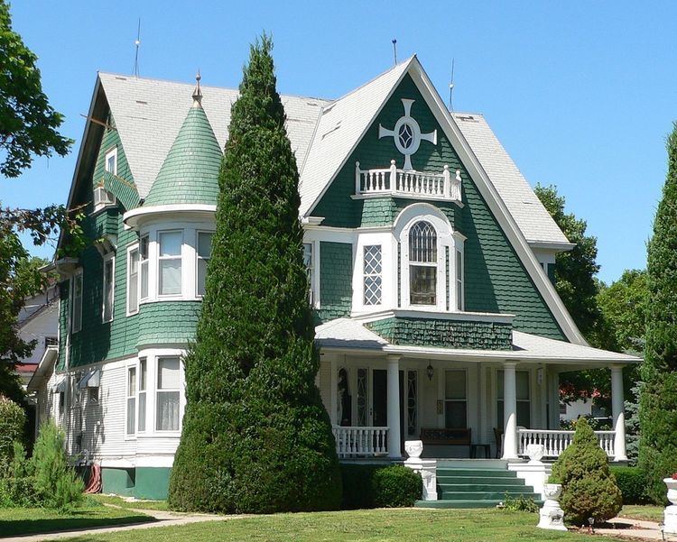
Superior bills itself as the "Victorian Capital of Nebraska", and holds an annual Victorian Festival. The downtown area is listed in the National Register of Historic Places; along with many of the older houses in the city, it has been maintained or restored to its Victorian appearance.
19th century
Superior was platted in 1875. It was named from the quality of their land.
In 1887, Atchison, Topeka and Santa Fe Railway built a branch line from Neva (3 miles west of Strong City) to Superior. At some point, the line from Neva to Lost Springs was pulled but the right of way has not been abandoned. This branch line was originally called "Strong City and Superior line" but later the name was shortened to the "Strong City line". In 1996, the Atchison, Topeka and Santa Fe Railway merged with Burlington Northern Railroad and renamed to the current BNSF Railway. Most locals still refer to this railroad as the "Santa Fe".
20th century
Superior was one of the smallest cities in America that supported a professional minor league baseball team, the Superior Senators (1956–58) of the Nebraska State League. Superior was the first professional stop in the career of pitcher Jim Kaat, who went on to win 283 games in a 24-year Major League career.
Geography
Superior is located at 40°1′21″N 98°4′1″W (40.022415, -98.067010). According to the United States Census Bureau, the city has a total area of 1.89 square miles (4.90 km2), all land.
2010 census
As of the census of 2010, there were 1,957 people, 948 households, and 527 families residing in the city. The population density was 1,037.6 people per square mile (400.6/km²). There were 1,109 housing units at an average density of 588 per square mile (227/km²).
The racial makeup of the city was 97% White, 0.2% African American, 0.5% Asian, 0.2% from other races, and 1.9% from two or more races. Hispanic or Latino of any race were 2% of the population.
There were 948 households of which 20% had children under the age of 18 living with them, 45.1% were married couples living together, 8% had a female householder with no husband present, and 44.4% were non-families. 21.3% of all households were made up of individuals living alone and 43.5% had someone living alone who was 65 years of age or older. The average household size was 2 and the average family size was 2.66.
In the city, the population was spread out with 19.6% under the age of 18, 8.8% from 18 to 24, 17.3% from 25 to 44, 26.6% from 45 to 64, and 31.4% who were 65 years of age or older. The median age was 51.3 years. For every 100 females there were 92 males. For every 100 females age 18 and over, there were 72 males.
2000 census
As of the census of 2000, there were 2,055 people, 980 households, and 598 families residing in the city. The population density was 1,090.6 people per square mile (422.0/km²). There were 1,123 housing units at an average density of 596.0 per square mile (230.6/km²). The racial makeup of the city was 98.83% White, 0.05% African American, 0.24% Asian, 0.54% from other races, and 0.34% from two or more races. Hispanic or Latino of any race were 1.02% of the population.
There were 980 households out of which 23.3% had children under the age of 18 living with them, 53.7% were married couples living together, 6.4% had a female householder with no husband present, and 38.9% were non-families. 36.7% of all households were made up of individuals and 21.4% had someone living alone who was 65 years of age or older. The average household size was 2.10 and the average family size was 2.72.
In the city, the population was spread out with 21.4% under the age of 18, 4.2% from 18 to 24, 21.0% from 25 to 44, 24.6% from 45 to 64, and 28.8% who were 65 years of age or older. The median age was 48 years. For every 100 females there were 82.8 males. For every 100 females age 18 and over, there were 81.1 males.
As of 2000 the median income for a household in the city was $28,405, and the median income for a family was $33,125. Males had a median income of $24,125 versus $21,542 for females. The per capita income for the city was $20,525. About 10.4% of families and 13.7% of the population were below the poverty line, including 35.2% of those under age 18 and 3% of those age 65 or over.
Government
The Superior government consists of a mayor and council members. The council meets the 2nd and 4th Monday of each month at 7:30PM.