
NV I‑15 → | ||
 | ||
Status: Feasibility study phase; one section (Hoover Dam Bypass) complete and open to traffic; second section (Boulder City Bypass) under construction | ||
Interstate 11 (I-11) is a proposed Interstate Highway, officially designated by the United States Congress in the 2015 Fixing America’s Surface Transportation Act. It is tentatively planned to run from Nogales, Arizona to Reno, Nevada along the current routes of Interstate 19, Interstate 10, U.S. Route 93, and U.S. Route 95.
Contents
- Map of I 11 Nevada USA
- Route description
- History
- Current status
- Funding
- Tucson extension plans
- Long term corridor plans
- References
Map of I-11, Nevada, USA
As originally proposed in the 2012 Surface Transportation Act, the highway would only run from Casa Grande, Arizona to Las Vegas, Nevada via Kingman and Buckeye, Arizona. This was to provide a direct Interstate link between the Las Vegas and Phoenix metropolitan areas.
The Interstate is congressionally enacted as cited above, and signs marking the "Future I-11 Corridor" are now posted in Arizona. There are two signs on the southbound side, at mile marker 2 and on US 93 just south of I-40; and two northbound signs north of Phoenix and Kingman on US 93. The involvement of American Association of State Highway and Transportation Officials (AASHTO) and the Federal Highway Administration (FHWA)—the agencies normally charged with Interstate Highway numbering and planning—has yet to occur.
The proposed numbering of the highway does not fit within the usual conventions of the existing Interstate Highway grid, as, at least in the initial phase south of Las Vegas, it would be completely east of I-15 and should therefore have a number greater than 15. But I-17 was already built to the east of the I-11 alignment in Arizona, making it impossible to fit this freeway into the national grid without violating the traditional numbering convention, since this is primarily a north–south route that would receive an odd number. Hence, the designation of I-11 was deemed the best option available. The subsequent plan to extend the Interstate north of Las Vegas to Reno would, if constructed, put that segment of I-11 west of I-15 and thus in line with the national grid numbering conventions.
Route description
As of December 2015, the highway was in a preliminary study phase, and an exact route has yet to be determined. A number of recommended corridor alternatives have been identified; a description of the route along these corridors follows.
The southern terminus of the freeway would be at Interstate 19 Business Loop in Nogales, Arizona concurrent with that of Interstate 19 proper. The freeway would then join Interstate 10 in Tucson and continue to Casa Grande.
At or near the interchange with I-8 and I-10 in Casa Grande, the freeway would split from I-10 and travel in a generally westward and then northward direction as a bypass route around the Phoenix Metropolitan Area. Two general corridor alternatives have been identified for this bypass section. One recommended alternative would have the highway running concurrently with I-8 west to Gila Bend, turning north at or near the existing intersection with Arizona State Route 85. The highway would then run concurrently with AZ 85 to its intersection with I-10 in Buckeye before turning west to run concurrently with I-10 for some miles. The second recommended alternative would have the highway run concurrently with I-8 east to an intersection with either Loop 303 or the Hassayampa Freeway, and then follow some combination of those highways, Arizona State Route 30, or AZ 85 to an intersection with I-10 in or near Buckeye.
North of I-10 near Buckeye, the study has identified a general corridor roughly parallel to the Hassayampa River with two more specific corridor alignments. The first would create a new highway running north to the U.S. Route 60 / State Route 74 intersection in Morristown before turning northwest to run concurrently with US 60 to its intersection with U.S. Route 93 in Wickenburg, thereafter running concurrently with US 93 to the northwest. The second alignment would follow the alignment of the Hassayampa Freeway as proposed by the Maricopa Association of Governments to an intersection with US 93 northwest of Wickenburg in Yavapai County.
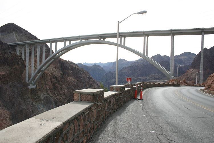
The highway would then run concurrently with US 93 through northern Arizona, including a concurrency with I-40 in and near Kingman. The highway would then cross the Mike O'Callaghan-Pat Tillman Memorial Bridge into Nevada. In Nevada, the highway would follow a planned bypass of US 93 around Boulder City, intersecting and running concurrently with U.S. Route 95 near Railroad Pass in Henderson.
Three alternative corridors have been identified for the highway's route through the Las Vegas Metropolitan Area. The first, a controversial proposal, due to cost and traffic concerns because the freeway is not expected to be completed for a long time, would have the highway continuing to run concurrently with US 93/95/I-515 to an interchange with the Las Vegas Beltway then running concurrently with that highway west and then north around the core of the metropolitan area. The highway would leave the route of the Beltway in northwestern Las Vegas, heading northward to near the intersection of US 95 and Nevada State Route 157. The second alternative has the highway following the US 93/95/I-515 concurrency to downtown Las Vegas, then running concurrently with US 95 to its intersection with NV 157 to the northwest. The third alternative, another controversial proposal, due to cost, environmental and traffic concerns, leaves the US 93/95 concurrency near Railroad Pass and runs north along a new route to an intersection with I-15/US 93 in or near North Las Vegas. The highway would then run concurrently with I-15/US 93 to the southwest until the intersection with the Las Vegas Beltway in North Las Vegas, following its route west to an intersection with US 95 and finally running concurrently with US 95 to the northwest to its intersection with NV 157. Under the original proposal, all three alternatives would have had the highway's northern terminus be at or near the intersection of US 95 and NV 157, but, Congress extended the freeway's designation in 2015 to include all of US 95 up to Interstate 80 in Reno.
History
As recently as 1997, US 93 was mostly a two-lane road between Phoenix and Las Vegas, and was known for its dangerous curves and hills in the stretch between Wickenburg and I-40. In the late 1990s, ADOT began widening US 93 to four lanes, and in some areas building a completely new roadway. In other places along the route, ADOT simply repaved the old highway and built two new lanes parallel to it. ADOT also began studying the possibility of adding grade separations to US 93 near the Santa Maria River to make the road a full freeway.
At the same time Nevada and Arizona began looking at US 93's crossing of Hoover Dam, a major bottleneck for regional commerce, with hairpin turns, multiple crosswalks for pedestrians and steep grades. Plans for a bridge to bypass the dam became even more urgent when the road was closed to trucks after September 11, 2001, forcing commercial traffic to detour through Bullhead City, Arizona, and Laughlin, Nevada.
With the completion of the Mike O'Callaghan-Pat Tillman Memorial Bridge in October 2010, the vast majority of the roadway is now a four-lane divided highway. Still, with Phoenix and Las Vegas being the two largest neighboring cities in the United States not connected by interstate highway, leaders in both cities are lobbying to include I-11 in the next Transportation Equity Act reauthorization. With the rise of the concept of "megapolitan" urban regions, Interstate 11 is considered a key connector to unify the triangle formed by Las Vegas, Phoenix, and the Los Angeles area (the triangle being I-15, I-11 and I-10).
On March 21, 2014, signs for I-11 were installed along the US 93 corridor, marking the official involvement of both Nevada's and Arizona's governors to fully build the interstate.
Current status
The only completed section of I-11 is the Hoover Dam bypass and the I-515 section in Nevada. However, the Federal Highway Administration (FHWA) has approved the Nevada Department of Transportation's (NDOT) environmental review of a bypass around Boulder City, which would connect the end of the recently constructed Hoover Dam bypass east of Boulder City to I-515 west of the town. The first stage of the bypass, which would offer a new connection from I-515 to US 95, began construction in 2012. The second stage which began construction in April 2015, is expected to complete the whole bypass by 2018. Once built, the Nevada portion of the Interstate 11 corridor will be a full freeway from northwestern Las Vegas to the Hoover Dam which will be ready with current interstate standards. All other sections of the corridor are in Arizona, like the 71 miles (114 km) of US 93 south of Hoover Dam, which is now a four-lane route from Kingman to the Hoover Dam. However, all Arizona portions of the corridor are not built to Interstate highway standards, as there are scattered at-grade intersections, substandard roadway widths, medians, and other deficiencies. Part of the dual roadways are repaved, restriped sections of very-old parts of U.S. 93. Farther south, a direct interchange with US 93 and I-40 is planned that will eliminate the bottleneck at Beale Street in Kingman.
Funding
The funding bill for the U.S. Department of Transportation, which replaced stopgaps that expired on June 30, 2012, officially designated I-11. This bill was passed by the Senate and the House in June 2012, and was signed by President Barack Obama.
This bill sped up funding for studying, engineering, and possibly building the highway, but it could still take a decade or two to complete. The high price tag makes I-11 in Arizona a leading candidate to become Arizona's first toll road. The legislature passed a law in 2009 that opened the door for private investors to team up with the Arizona Department of Transportation.
In July 2012, Nevada's Transportation Board awarded $2.5 million in contracts to a team of consultants to study I-11's feasibility and its environmental and economic consequences.
Tucson extension plans
Officials in Pima County support an extension of the planned I-11 from Casa Grande which would wrap southwest of the Tucson Mountains before meeting with I-19 in Sahuarita, south of Tucson, and continuing east to I-10. Over 800 residents have signed a petition opposing that west-side by-pass because it would impact the Arizona Sonora Desert Museum, the Saguaro National Park and the Ironwood Forest National Monument. They recommend instead that the I-11 segment be built on top of the existing I-10 route through Tucson. The additional segment would create the Tucson bypass route identified as a critical need by the Arizona Department of Transportation based upon I-10 traffic projections. Supporters of the extension cite tremendous economic benefit to the Tucson region.
Long-term corridor plans
I-11 was previously projected to serve as an Intermountain West part of the US's long-term CANAMEX Corridor transportation plans, with potential extensions south from Casa Grande to the Sonoran border, and north from Las Vegas through northern Nevada (potentially passing through Reno or Elko) and onward through either eastern Oregon/Washington or western Idaho before terminating at the Canadian border. As of December 2015, I-11 is projected to become the Intermountain West Corridor, extending from Phoenix and Las Vegas through Reno to the Pacific Northwest via central or eastern Oregon and central Washington. Feasibility studies for these corridor extensions began in July 2013 and were published in November 2014.
The proposal to extend I-11 to the Reno area is supported by both of Nevada's U.S. Senators, Harry Reid and Dean Heller, as well as the rest of Nevada's delegation to the U.S. Congress. Heller stated that connecting the Phoenix area with Las Vegas and Northern Nevada would "spur long-term economic development, create jobs, and bolster international trade". The 2015 FAST Act gave Congressional approval to the proposed extensions in Nevada and Arizona, but not to extensions north of I-80 in Reno.