
Visitors 820,426 (in 2016) | Established October 4, 1994 Governing body National Park Service | |
 | ||
Area 91,716 acres (37,116 ha) | ||
Saguaro National Park in southern Arizona is part of the National Park System in the United States. The park preserves the desert landscape, fauna, and flora in two park districts, one east and the other west of Tucson. The park was established to protect its namesake—the giant saguaro cactus (Carnegiea gigantea)—which at this latitude is near the northern limit of its natural range within the Sonoran Desert.
Contents
OverviewEdit
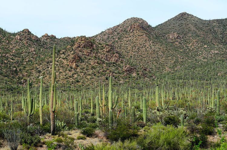
The park consists of two separate parcels—the Tucson Mountain District (TMD) and the Rincon Mountain District (RMD)—that lie about 20 miles (32 km) east and 15 miles (24 km) west of the center of the city of Tucson, Arizona. Their total combined area in 2016 was 91,716 acres (37,116 ha) of which 70,905 acres (28,694 ha) was designated wilderness. Each district has a visitor center within easy reach by car from Tucson. Both districts conserve tracts of the Sonoran Desert, including ranges of significant hills, the Tucson Mountains in the west and the Rincon Mountains in the east.
The park gets its name from the saguaro, a large cactus that is native to the Sonoran Desert and does not grow naturally elsewhere. Saguaros grow at an exceptionally slow rate. The first arm of a saguaro typically starts growing sometime between 50 and 70 years of age though it may be closer to 100 years in locations where precipitation is very low. A mature saguaro may grow up to 60 feet (18 m) tall and weigh up to 4,800 pounds (2,200 kg) when fully hydrated. The total number of saguaros in the park is estimated at 1.8 million. Many other kinds of cactus, including barrel, cholla, and prickly pear, are abundant in the park.
Facilities in the park include more than 165 miles (266 km) of hiking trails. The National Park Service (NPS) publishes safety guidelines for these hikes, including advice about how to avoid extreme heat, dehydration, flash floods, cactus spines, snakes, cougars, and other dangers. According to the NPS, many people prefer to visit the park between October and April, when daytime temperatures may reach 70 to 80 °F (21 to 27 °C) and nighttime temperatures may drop below freezing. During the hottest season, May through September, daily high temperatures average more than 100 °F (38 °C).
EarlyEdit
The earliest known residents of the land in and around what later became Saguaro National Park were the Hohokam, who lived there in villages between 200 and 1450 A.D. Hunting and gathering wild foods, they also grew corn, beans, and squash. Petroglyphs and bits of broken pottery are among Hohokam artifacts found in the park. Subsequent indigenous cultures, the Sobaipuri of the Tucson Basin and the Tohono O’odham to the west may be descendants of the Hohokam. They hunted deer and other animals and gathered cholla buds, prickly pears, palo verde pods, saguaro fruit, and other plant foods to supplement their diet.
Spanish explorers first entered Arizona in 1539–40. Non-native settlement of the region near the park did not occur until 1692 with the founding of San Xavier Mission along the Santa Cruz River, which flowed through Tucson. In 1775, the Spaniards built Presidio San Augustin del Tucson, a military fort in what was then part of New Spain, in part to protect against raids by Apaches.
The lands that eventually would become Saguaro National Park remained relatively free of development until the mid-19th century, after Arizona had become part of the United States. After passage of the Homestead Act of 1862, the arrival of the railroad in 1880, and the end of the Apache Wars in 1886, miners, homesteaders, and ranchers established themselves in the Tucson and Rincon Mountains. Miners sought silver, copper, and other valuable ores and minerals such as lime. The defunct Loma Verde Mine in the RMD and abandoned lime kilns in both districts are still visible. Ranchers grazed thousands of cattle on public land that would later become part of the park, and homesteaders farmed and ranched at the base of the Rincons. The site of one of them, the former Freeman Homestead, lies along a nature trail in the RMD.
After 1920Edit
In 1920 members of the Natural History Society of the University of Arizona expressed interest in establishing a protected area for saguaro, a cactus species familiar to watchers of silent-movie Westerns. In 1928 Homer L. Shantz, a plant scientist and the university's president, joined the efforts to create a saguaro sanctuary. However, issues related to funding and management delayed the creation of a park. In 1933 Frank Harris Hitchcock, publisher of the Tucson Citizen, former United States Postmaster General, and a force in the Republican Party, persuaded U.S. President Herbert Hoover to create Saguaro National Monument. Hoover used his power under the Antiquities Act of 1906 to create the monument by proclamation on March 1, 1933. Later in 1933 President Franklin D. Roosevelt transferred management of the new monument to the National Park Service. Between 1936 and 1939, during the Roosevelt administration, the Civilian Conservation Corps (CCC) built the monument's Cactus Forest Loop Drive and related infrastructure. The monument's visitor center opened in the 1950s.
In 1961 President John F. Kennedy—urged on by Stewart Udall, an Arizonan who was then Secretary of the Interior—added 25 square miles (65 km2) of cactus lands in the Tucson Mountains to the monument. This western district of the monument was carved from Tucson Mountain Park, managed by Pima County. In the 1920s, the Tucson Game Protective Association had persuaded the Department of the Interior to withdraw about 30,000 acres (12,000 ha) in the Tucson Mountains from homesteading and mining and to set it aside as a park and game refuge. Land leased by the county in this set-aside became Tucson Mountain Recreation Area in 1932. Between 1933 and 1941 CCC workers built structures at eight picnic areas in the county park portion of the set-aside, five of which later became part of the Tucson Mountain District of the national monument. They also worked on erosion control, water supplies for wildlife, road, trails, and landscaping. Kennedy's 1961 proclamation created the TMD from the northern part of the county park and renamed the original monument lands east of Tucson the Rincon Mountain District. Expansions in 1976 and 1994 brought the total TMD acreage to 24,818 acres (10,043 ha). In 1994 Congress elevated the combined TMD and RMD to National Park status.
GeologyEdit
The Tucson Basin and nearby mountains—including the Tucson Mountains to the west, the Santa Catalinas to the north, and the Rincons to the east—as well as Saguaro National Park, are part of the Basin and Range Province extending from northern Mexico to southern Oregon in the United States. The Basin and Range is of relatively recent geologic origin. Saguaro National Park's oldest rocks, the Pinal Schist, pre-date the formation of the Basin and Range by about 1.7 billion years. The schist is exposed in the RMD along a dry wash off Cactus Forest Loop Drive. Other ancient rocks, 1.4-billion-year-old altered granites, form much of Tanque Verde Ridge, also in the RMD.
Much later, about 600 million years ago, shallow seas covered the region around present-day Tucson; over time that led to deposition of sedimentary rocks——limestones, sandstones, and shales. Limestone, which occurs in the park in several places, was mined here in the late 19th century to make mortar. The future park land had six lime kilns, two in the TMD, and four in the RMD. Three, all in the RMD, can be visited today—two along the Cactus Forest Trail and one along the Ruiz Trail.
About 80 million years ago tectonic plate movements induced a period of mountain building, the Laramide orogeny, in western North America. Explosive volcanic eruptions formed the Tucson Mountains, and the roof of the volcano at their center collapsed to form a caldera 12 miles (19 km) across. Subsequent lava flows, debris flows, and the intrusion of a granitic pluton eventually filled the caldera. Volcanic rocks exposed in and near the TMD in the 21st century are remnants of these events. Examples include large breccia exposed at Grants Pass and a granitic remnant of the magma chamber, which is visible from the Sus Picnic Area in the TMD. However, not all of the molten granite reached the surface of the Tucson Mountains; instead, it cooled and crystallized far below.
Formation of the Basin and Range began when plate movements stretched and thinned the Earth's crust in this part of western North America until it pulled apart along faults. The Catalina Fault, a low-angle detachment fault, began to form about 30 million years ago about 6 to 8 miles (10 to 13 km) below the surface of the Tucson Mountains. The rocks under the fault, the lower-plate rocks, were eventually displaced 16 to 22 miles (26 to 35 km) east-northeast relative to the rocks above the fault, then uplifted, domed, and eroded to form the Santa Catalina and Rincon mountains visible today. Although the volcanic rocks seen on the surface of the TMD are not found in the RMD, the crystallized granite (Catalina gneiss) from beneath the Tucson Mountains was eventually exposed on the RMD's surface. The most common rock type in the Rincon Mountains, this banded gneiss is visible in the RMD at sites such as Javelina Rocks along the Cactus Forest Loop Drive.
Rincon Mountain District (east)Edit
The RMD, at the eastern edge of Tucson off South Old Spanish Road, includes the land protected in the original National Monument. The district features the 8.3-mile (13.4 km) Cactus Forest Loop Drive, which provides access to two picnic areas and the central trails. Hiking on this side of the park is readily accessible to visitors not only from the Loop Drive but from trailheads near the east ends of two of the city's boulevards, Speedway and Broadway. In addition, about 7 miles (11 km) south of the park entrance is another trailhead at the north end of Camino Loma Alta. It serves the Hope Camp and Ridge View trails, used by equestrians as well as hikers. This section of the park was added in 1991 when Congress authorized the purchase of an additional 4,011 acres (1,623 ha).
Elevations within the district vary from 2,670 to 8,666 feet (814 to 2,641 m), and annual precipitation varies from about 12 inches (300 mm) at the lowest point to 30 inches (760 mm) at the highest. Plant communities at the lower elevations are typical of the Sonoran Desert, while the Rincon Mountains support conifers and other trees. Specifically, the district's six plant communities from lowest to highest elevations are desert scrub, desert grassland, oak woodland, pine-oak woodland, pine forest and mixed conifer forest. The highest peak in this range is Mica Mountain.
There are no campgrounds accessible by road in the park, but the RMD is open to backcountry camping at designated sites. The site closest to a road is the Douglas Spring Campground, which requires a hike of about 6 miles (10 km). A wilderness permit is required for all overnight stays.
Tucson Mountain District (west)Edit
The TMD lies slightly west of Tucson along North Kinney Road off Gates Pass Road. Smaller than the RMD, it covers 24,818 acres (10,043 ha). This district has 12 miles (19 km) of paved roads and 8.5 miles (13.7 km) of unpaved roads, including the 5-mile (8 km) Bajada Loop Drive. Trails include the Cactus Garden Trail at the visitor center, the Desert Discovery Nature Trail, and the Valley View Overlook Trail, all easily accessible from Kinney Road or Bajada Loop Drive, and the park has more difficult trails such as the Hugh Norris Trail leading to Wasson Peak. Four of the district's five picnic areas are along park roads, and one is accessible only by trail.
Elevation in the district ranges from 2,180 to 4,687 feet (664 to 1,429 m), the summit of Wasson Peak. The TMD, which consists mainly of desert scrub and desert grassland, receives an average of about 10 inches (250 mm) of precipitation a year.
Hohokam petroglyphs etched into large stones are easily seen in the TMD. The Signal Hill Trail, which begins at the Signal Hill Picnic Area along the Bajada Loop Drive, leads to an area with dozens of examples of the 800-year-old rock art.
FaunaEdit
An inventory of medium and large mammals in the park confirmed the presence of 30 species in Saguaro National Park between 1999 and 2008. Of these, 21 were found in the TMD and 29 in the RMD. A partial list of the park's mammals includes cougars, coyotes, bobcats, white-tailed deer, mule deer, javelinas, gray foxes, black-tailed jackrabbits, desert cottontails, ring-tailed cats, white-nosed coatis, ground squirrels, and packrats.
Some of the bird species include great horned owls, ravens, kestrels, turkey vultures, roadrunners, woodpeckers, hawks, quails, and hummingbirds.
Reptile species include desert tortoises, diamondback rattlesnakes (one of the more commonly seen snakes), coral snakes, Gila monsters, short-horned lizards, spiny lizards, and zebra-tailed lizards.
One endangered animal, the lesser long-nosed bat, lives part of the year in the park and part of the year in Mexico. The park is also home to one threatened species, the Mexican spotted owl.