
Length 473.1 km | ||
 | ||
Counties | ||
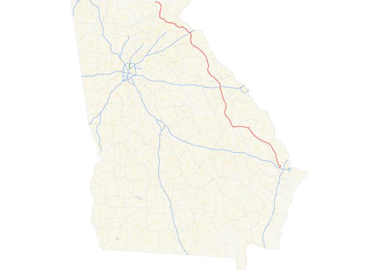
State Route 17 (SR 17) is a 294-mile-long (473 km) state highway that travels south-to-north through portions of Chatham, Effingham, Screven, Jenkins, Burke, Jefferson, Warren, McDuffie, Wilkes, Elbert, Hart, Franklin, Stephens, Habersham, White, and Towns counties in the east-central and northeastern parts of the U.S. state of Georgia. The highway connects Interstate 16 (I-16) south of Bloomingdale to the North Carolina state line, northwest of Hiawassee, via Millen, Louisville, Wrens, Thomson, Washington, Elberton, Royston, Toccoa, Clarkesville, and Hiawassee.
Contents
- Map of GA 17 Georgia USA
- From Bloomingdale to Washington
- From Washington to Toccoa
- From Toccoa to Young Harris
- Millen bypass route
- Warren County connector
- Thomson bypass route
- Washington business loop
- Royston business loop
- Alternate route
- References
Map of GA-17, Georgia, USA
From Bloomingdale to Washington
SR 17 begins at exit 152 on I-16, the westernmost exit for I-16 in Chatham County. SR 17 travels north to Bloomingdale, where it begins a concurrency with US 80/SR 26 westward. After entering Effingham County, SR 17 departs US 80/SR 26, and continues northwest, paralleling the Ogeechee River through rural parts of Effingham, Screven, and Jenkins Counties before arriving in Millen.
After a short concurrency with SR 23 and SR 67 in Millen, SR 17 continues west, then northwest, still parallel to the Ogeechee River, to Louisville. SR 17 travels concurrent with US 1/US 221/SR 4 from Louisville north to Wrens. In Wrens, SR 17 departs and continues to the northwest to Thomson.
In Thomson, SR 17 travels concurrent with US 78/SR 10 north to Washington. Just north of Thomson is an interchange with I-20. In Washington, SR 17 intersects US 378, and departs the concurrency with US 78/SR 10, before leaving the town.
From Washington to Toccoa
After traveling through Washington, SR 17 travels through the small town of Tignall as it continues into the mountains of northeast Georgia, first passing through Elberton, where it has a short concurrency with SR 72, then Bowman, where it intersects SR 172, and bypassing the main part of the city of Royston.
In Canon, it intersects and begins to travel concurrent with SR 51; the concurrency ends in the small town of Bowersville, where SR 51 departs east towards Hartwell, and SR 17 heads north towards the city of Lavonia. In Lavonia, SR 17 goes through downtown before becoming a divided highway as it has a partial cloverleaf interchange with I-85 just north of downtown Lavonia. Afterwards, the divided highway ends, and SR 17 continues on its way through rural Stephens County before reaching the city of Toccoa.
From Toccoa to Young Harris
Southeast of Toccoa, the highway turns to a westerly direction, bypassing the city on another divided highway towards Clarkesville, traveling concurrent with US 123/SR 365 in the process. Sometime after entering Habersham County, the highway departs northwest, with US 123 ending soon after and SR 365 heading southwest towards the cities of Gainesville and Atlanta. There is a concurrency with SR 115 somewhere around the Clarkesville area. Outside of Clarkesville, the highway continues northwest, traveling through the historic Nacoochee Valley.
SR 17 then begins a concurrency with SR 75. The highways travel north through the tourist town of Helen. The two highway continue north over Unicoi Gap, then descend into the Hiawassee River valley. East of the town of Hiawassee, Georgia, the highways begin a concurrency with US 76/SR 2.
In Hiawassee, SR 75 departs to the northeast. A few miles to the west, north-northeast of Young Harris, SR 17 departs US 76/SR 2, and begins a short concurrency to the north with SR 515 until they both reach their northern terminus at the North Carolina state line. The road continues into North Carolina as North Carolina Highway 69 (NC 69).
The following sections of SR 17 are included as part of the National Highway System, a system of roadways important to the nation's economy, defense, and mobility:
Millen bypass route
State Route 17 Bypass (SR 17 Byp.) is a 1.5-mile-long (2.4 km) bypass route that exists entirely within the central part of Jenkins County. Nearly the entire route is within the city limits of Millen.
It begins at an intersection with the SR 17 mainline (South Masonic Street) just south of town. It heads northwest into town on Recreation Drive. Then, it curves to the west-southwest on South Gray Street. A few blocks later, it intersects US 25/SR 23/SR 67/SR 121 (Statesboro Road). The five highways travel concurrently to the north-northeast and curve to a nearly due-north routing. At SR 17 (West Winthrope Avenue), SR 23/SR 67 leaves the concurrency to the right on SR 17 south, US 25/SR 121 continue straight ahead, and SR 17 Byp. reaches its northern terminus.
The only part of SR 17 Byp. that is included as part of the National Highway System, a system of roadways important to the nation's economy, defense, and mobility, is the part concurrent with US 25/SR 23/SR 67/SR 121.
The entire route is in Jenkins County.
Warren County connector
State Route 17 Connector (SR 17 Conn.) is a 7.3-mile-long (11.7 km) connecting route of SR 17 that exists in rural areas of Warren County, northwest of Wrens, southeast of Warrenton, and south of Thomson. It serves to connect SR 17 north-northwest of Wrens with SR 80 southeast of Warrenton. It has no junctions between its termini.
The entire route is in Warren County.
Thomson bypass route
State Route 17 Bypass (SR 17 Byp.) is a 7.4-mile-long (11.9 km) bypass route that exists entirely within the central part of McDuffie County. Its entire length is a bypass of Thomson.
It begins at an intersection with the SR 17 mainline (Wrens Highway) south-southeast of town. It heads northeast and curves to the north-northeast and intersects US 78/SR 10 and US 278/SR 12 (Augusta Highway). At this intersection, US 78/SR 10 travel concurrent with SR 17 Byp., while US 278 heads to the west, concurrent with SR 12 and enters Thomson. After this intersection, US 78/SR 10/SR 17 Byp. travel to the northeast and curve to the north-northwest before intersecting SR 223 (White Oak Road). After curving to a due-west orientation, the concurrency bends to the northwest and briefly enters town. Immediately after crossing the city limits, they intersect SR 150 (Cobbham Road). The three highways curve back to the north-northwest and leave town. Farther along, they cross over, without an interchange with, Interstate 20 (I-20; Carl Sanders Highway). A few thousand feet farther to the north-northwest, they curve to the west-northwest and intersect the SR 17 mainline (Washington Road). At this intersection, SR 17 Byp. reaches its northern terminus, and US 78/SR 10 turn right onto SR 17 north.
SR 17 Byp. is not part of the National Highway System, a system of roadways important to the nation's economy, defense, and mobility.
The entire route is in McDuffie County.
Washington business loop
State Route 17 Business (SR 17 Bus.) is a 2.7-mile-long (4.3 km) business route that exists entirely within the south central part of Wilkes County. Nearly all of the route is contained within the city limits of Washington.
It begins at an intersection with US 78/SR 10/SR 17 (Sam McGill Parkway) on the southeastern edge of the city limits of Washington. This intersection also marks the western terminus of US 378 and the eastern terminus of US 78 Bus./SR 10 Bus., which, along with SR 47, are concurrent with SR 17 Bus. from its southern terminus. US 78 Bus./SR 10 Bus./SR 17 Bus./SR 47 travel northwest into the main part of town on East Robert Toombs Avenue. Just after passing the Robert Toombs House, SR 17 Bus. departs the concurrency by turning right onto Poplar Drive. The highway travels to the north and begins a gradual curve to the north-northeast. A few blocks later, it intersects US 78/SR 10/SR 44 (Lexington Road). SR 17 Bus./SR 44 head concurrent for one block. At Danburg Road, SR 44 splits off to the east. It gently curves to the northwest before curving back to the north-northeast and meeting its terminus, a second intersection with the SR 17 mainline (Tignall Road), north of town.
SR 17 Bus0 is not part of the National Highway System, a system of roadways important to the nation's economy, defense, and mobility.
The entire route is in Wilkes County.
Royston business loop
State Route 17 Business (SR 17 Bus.) is a 2.2-mile-long (3.5 km) business route that exists within portions of Hart and Franklin counties in the northeastern part of the U.S. state of Georgia. Except for the very beginning of the highway, the entire route is within the city limits of Royston.
It begins at an intersection with the SR 17 mainline just southwest of town, in Hart County. It travels northwest, enters the city limits, and passes Rose Hill Cemetery. Just past the cemetery, it enters Franklin County. The highway curves to the north and meets the northern terminus of SR 281 (Wildcat Bridge Road). After beginning a very gradual slant to the north-northeast, it intersects US 29/SR 8 (Hartwell Street). The highway slightly bends to the north-northwest and meets its northern terminus, a second intersection with the SR 17 mainline.
SR 17 Business is not part of the National Highway System, a system of roadways important to the nation's economy, defense, and mobility.
Alternate route
State Route 17 Alternate (SR 17 Alt.) is a 19.4-mile-long (31.2 km) alternate route that exists within portions of Stephens and Habersham counties in the northeastern part of the U.S. state of Georgia. The highway connects the Toccoa area with Clarkesville, via Toccoa Falls. Part of the highway, from Hollywood to Clarkesville, travels along a former section of U.S. Route 441.
It begins at an intersection with the SR 17 mainline (Toccoa Bypass), at a point on the far southeastern edge of Toccoa (and north of Eastanollee). The highway travels in a northeasterly direction on South Big A Road. It passes Stephens County Memorial Gardens and continues toward the main part of town. It has an intersection with US 123/SR 365 (East Currahee Street). It curves to the west-southwest and intersects SR 184 (Prather Bridge Road). The two highways travel concurrently through town until they reach Broad Street. They split, with SR 184 heading south and SR 17 Alt. heading north. At Toccoa Cemetery, SR 17 Alt. turns to the left onto Toccoa Falls Road and travels to the northwest. Then, it leaves town, travels through Toccoa Falls, and enters the Chattahoochee-Oconee National Forest. In a curving fashion, it travels to the northwest, passing the Toccoa Reservoir. Roughly halfway through its forest section, SR 17 Alt. enters Habersham County. On the edge of leaving the forest, it intersects US 23/US 441/SR 15. This intersection also marks the northern terminus of US 441 Bus./SR 385, which travel concurrent with the highway southwest of here. The three highways enter Clarkesville. In town, they intersect SR 197, which joins the concurrency. The four highways travel to the southwest on Grant Street and curve to the southeast on Washington Street. At Monroe Avenue, they intersect the SR 17 mainline. At this intersection, SR 17 Alt. meets its northern terminus, SR 115 meets its eastern terminus, and SR 17 joins the concurrency.
SR 17 Alt., from its southern terminus to the northwest part of Toccoa, is included as part of the National Highway System, a system of roadways important to the nation's economy, defense, and mobility.