
County Jefferson FIPS code 13-47560 Elevation 98 m Population 2,398 (2013) Area code 478 | Time zone Eastern (EST) (UTC-5) GNIS feature ID 0332271 Zip code 30434 Local time Monday 3:05 PM | |
 | ||
Weather 6°C, Wind N at 11 km/h, 98% Humidity Area 9.583 km² (9.324 km² Land / 26 ha Water) | ||
Old town louisville georgia
Louisville is a city in Jefferson County, Georgia, United States. It was an early capital of Georgia and is the county seat of Jefferson County. It is located southwest of Augusta on the Ogeechee River, and its population was 2,712 at the 2000 census. Though the name is of French origin, it is pronounced "Lewis-ville."
Contents
- Old town louisville georgia
- Map of Louisville GA 30434 USA
- How to say or pronounce usa cities louisville georgia
- Geography
- Demographics
- Jefferson County School District
- Private education
- References
Map of Louisville, GA 30434, USA
Louisville was laid out in 1786 as the prospective state capital. Georgia ratified the United States Constitution in 1788. Savannah had served as the colonial capital; but it was considered too far from the center of the growing state. Louisville was named for Louis XVI, who was still the King of France and had aided the Continentals during the successful American Revolutionary War. Development of the city began later, and its state government buildings were completed in 1795.
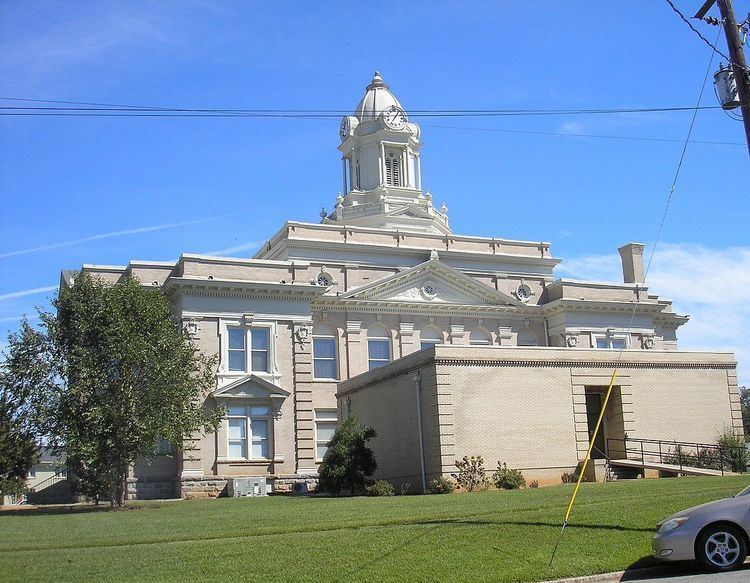
The city of Louisville served as the state capital of Georgia from 1796 to 1806. The Jefferson County courthouse, built in 1904, stands on the site of Georgia's first permanent capitol building.
Louisville's historic market house still stands in the center of downtown. The original market had sections for everything from farm produce and household goods to slaves. The Old Market is listed on the National Register of Historic Places. The market square became the hub of the transportation routes which centered on Louisville while the town was the state's capital.
As a small city and county seat, the city now has few major businesses and industries. Queensborough National Bank and Trust Company was founded in 1902 and is currently headquartered in Louisville, on U.S. Highway 1.
A marker dedicated to the Yazoo land scandal is located in front of the county courthouse.
How to say or pronounce usa cities louisville georgia
Geography
Louisville is located at 33°0′15″N 82°24′18″W (33.004291, -82.404588).
According to the United States Census Bureau, the city has a total area of about 3.7 square miles (9.5 km²).
Demographics
As of the census of 2000, there were 2,712 people, 994 households, and 664 families residing in the city. The population density was 755.5 people per square mile (291.7/km²). There were 1,123 housing units at an average density of 312.8 per square mile (120.8/km²). The racial makeup of the city was 65.93% African American, 33.63% White, 0.04% Native American, 0.22% Asian, 0.07% from other races, and 0.11% from two or more races. Hispanic or Latino of any race were 0.37% of the population.
There were 994 households out of which 33.4% had children under the age of 18 living with them, 35.8% were married couples living together, 27.4% had a female householder with no husband present, and 33.1% were non-families. 31.4% of all households were made up of individuals and 16.1% had someone living alone who was 65 years of age or older. The average household size was 2.56 and the average family size was 3.22.
In the city, the population was spread out with 28.2% under the age of 18, 8.3% from 18 to 24, 25.1% from 25 to 44, 19.9% from 45 to 64, and 18.5% who were 65 years of age or older. The median age was 37 years. For every 100 females there were 77.7 males. For every 100 females age 18 and over, there were 71.8 males.
The median income for a household in the city was $19,883, and the median income for a family was $32,578. Males had a median income of $31,500 versus $16,921 for females. The per capita income for the city was $15,028. About 23.1% of families and 28.9% of the population were below the poverty line, including 27.8% of those under age 18 and 51.8% of those age 65 or over.
Jefferson County School District
The Jefferson County School District holds pre-school to grade twelve, and consists of two elementary schools, two middle schools, a high school, and an academy school. The district has 199 full-time teachers and over 3,526 students.