
Congressional district 10th Founded 20 February 1796 Unemployment rate 8.7% (Apr 2015) | Area 1,373 km² Population 16,320 (2013) | |
 | ||
Rivers Ogeechee River, Rocky Comfort Creek, Brier Creek | ||
52 acres in jefferson county georgia for sale
Jefferson County is a county located in the U.S. state of Georgia. As of the 2010 census, the population was 16,930. The county seat is Louisville. The county was created on February 20, 1796 and named for Thomas Jefferson, the third president of the United States.
Contents
- 52 acres in jefferson county georgia for sale
- Map of Jefferson County GA USA
- Geography
- Demographics
- Cities
- Town
- Census designated place
- References
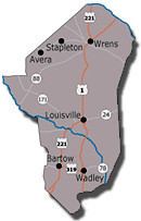
Map of Jefferson County, GA, USA
Geography
According to the U.S. Census Bureau, the county has a total area of 530 square miles (1,400 km2), of which 526 square miles (1,360 km2) is land and 3.2 square miles (8.3 km2) (0.6%) is water.
The small northern portion of Jefferson County, defined by a line running from Stapleton southeast and just south of State Route 80, is located in the Brier Creek sub-basin of the Savannah River basin. The entire rest of the county is located in the Upper Ogeechee River sub-basin of the Ogeechee River basin.
Demographics
As of the 2010 United States Census, there were 16,930 people, 6,241 households, and 4,407 families residing in the county. The population density was 32.2 inhabitants per square mile (12.4/km2). There were 7,298 housing units at an average density of 13.9 per square mile (5.4/km2). The racial makeup of the county was 54.4% black or African American, 42.6% white, 0.4% Asian, 0.1% American Indian, 1.6% from other races, and 0.9% from two or more races. Those of Hispanic or Latino origin made up 3.1% of the population. In terms of ancestry, and 26.7% were American.
Of the 6,241 households, 36.0% had children under the age of 18 living with them, 41.9% were married couples living together, 23.4% had a female householder with no husband present, 29.4% were non-families, and 26.0% of all households were made up of individuals. The average household size was 2.63 and the average family size was 3.16. The median age was 38.8 years.
The median income for a household in the county was $29,268 and the median income for a family was $36,980. Males had a median income of $36,284 versus $27,191 for females. The per capita income for the county was $15,165. About 19.0% of families and 26.9% of the population were below the poverty line, including 40.7% of those under age 18 and 24.8% of those age 65 or over.