
Named for Alexander Stephens Congressional district 9th Area 476.6 km² Population 25,683 (2013) Cities Toccoa, Avalon | Largest city Toccoa Time zone Eastern: UTC-5/-4 Founded 1905 County seat Toccoa University Toccoa Falls College | |
 | ||
Points of interest Toccoa Falls, Currahee Mountain, Lake Hartwell, Toccoa Falls Waterfall, Henderson Falls Park | ||
Stephens County is a county located in the U.S. state of Georgia. As of the 2010 census, the population was 26,175. The county seat is Toccoa.
Contents
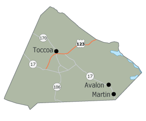
- Map of Stephens County GA USA
- History
- Geography
- Adjacent counties
- National protected area
- Demographics
- Communities
- References
Map of Stephens County, GA, USA
Stephens County comprises the Toccoa, GA Micropolitan Statistical Area.
History
Originally inhabited by Mississippi Indian mound builders and then by Cherokee Indians, the first non-Indians in the area were Revolutionary War veterans who migrated up the Savannah River and the Tugaloo River after the war. Created on August 18, 1905 from parts of Franklin County and Habersham County, the county is named for Alexander Stephens, U.S. representative, Vice President of the Confederate States of America, and fifty-third governor of Georgia.
Two courthouses have served Stephens County. The first courthouse was built in 1908, and is now on the National Register of Historic Places. The second was built in 2000.
Geography
According to the U.S. Census Bureau, the county has a total area of 184 square miles (480 km2), of which 179 square miles (460 km2) is land and 5.1 square miles (13 km2) (2.8%) is water.
The northern half of Stephens County is located in the Tugaloo River sub-basin of the Savannah River basin, while the southern half of the county is located in the Broad River sub-basin of the same Savannah River basin.
Adjacent counties
National protected area
Demographics
As of the 2010 United States Census, there were 26,175 people, 10,289 households, and 7,236 families residing in the county. The population density was 146.1 inhabitants per square mile (56.4/km2). There were 12,662 housing units at an average density of 70.7 per square mile (27.3/km2). The racial makeup of the county was 85.1% white, 10.9% black or African American, 0.7% Asian, 0.3% American Indian, 0.1% Pacific islander, 1.0% from other races, and 2.0% from two or more races. Those of Hispanic or Latino origin made up 2.4% of the population. In terms of ancestry, 14.7% were American, 9.1% were Irish, 8.1% were German, and 7.4% were English.
Of the 10,289 households, 31.5% had children under the age of 18 living with them, 52.8% were married couples living together, 13.2% had a female householder with no husband present, 29.7% were non-families, and 25.7% of all households were made up of individuals. The average household size was 2.49 and the average family size was 2.96. The median age was 40.7 years.
The median income for a household in the county was $34,938 and the median income for a family was $41,768. Males had a median income of $35,814 versus $24,834 for females. The per capita income for the county was $18,285. About 12.3% of families and 18.8% of the population were below the poverty line, including 25.9% of those under age 18 and 16.0% of those age 65 or over.