
Founded 25 February, 1784 Area 688.9 km² University Emmanuel College | Population 22,009 (2013) | |
 | ||
Website www.franklincountyga.com Rivers Hudson River, Nails Creek, North Fork Broad River | ||
Franklin County is a county located in the U.S. state of Georgia. As of the 2010 census, the population was 22,084. The county seat is Carnesville. On February 25, 1784 Franklin and Washington became Georgia's eighth and ninth counties, with Franklin named in honor of patriot Benjamin Franklin.
Contents
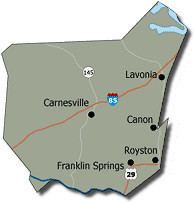
- Map of Franklin County GA USA
- Economic development
- Geography
- Adjacent counties
- 2000 census
- 2010 census
- Cities
- Town
- Census designated place
- References
Map of Franklin County, GA, USA
In its original form, Franklin County included all of the territory now in Banks, Barrow, Clarke, Jackson, Oconee, and Stephens counties, and parts of the modern-day Gwinnett, Hall, Hart, and Madison counties, as well as three counties that are now part of South Carolina.
Economic development
The Franklin County Industrial Building Authority, one of only seven created by a Georgia constitutional amendment, actively seeks and recruits new industries to the county. The Authority consists of seven members: each of the five mayors from the cities within Franklin County, and two at-large members selected by the Board of Commissioners.
Geography
According to the U.S. Census Bureau, the county has a total area of 266 square miles (690 km2), of which 261 square miles (680 km2) is land and 5.0 square miles (13 km2) (1.9%) is water.
The majority of Franklin County is located in the Broad River sub-basin of the Savannah River basin, with just the northeastern corner, north of Lavonia, located in the Tugaloo River sub-basin of the same Savannah River basin.
Adjacent counties
2000 census
As of the census of 2000, there were 20,285 people, 7,888 households, and 5,695 families residing in the county. The population density was 77 people per square mile (30/km²). There were 9,303 housing units at an average density of 35 per square mile (14/km²). The racial makeup of the county was 89.49% White, 8.83% Black or African American, 0.21% Native American, 0.25% Asian, 0.02% Pacific Islander, 0.41% from other races, and 0.78% from two or more races. 0.92% of the population were Hispanic or Latino of any race.
There were 7,888 households out of which 31.10% had children under the age of 18 living with them, 57.20% were married couples living together, 10.50% had a female householder with no husband present, and 27.80% were non-families. 24.60% of all households were made up of individuals and 11.60% had someone living alone who was 65 years of age or older. The average household size was 2.50 and the average family size was 2.96.
In the county, the population was spread out with 23.90% under the age of 18, 9.60% from 18 to 24, 27.30% from 25 to 44, 23.80% from 45 to 64, and 15.30% who were 65 years of age or older. The median age was 38 years. For every 100 females there were 94.10 males. For every 100 females age 18 and over, there were 90.90 males.
The median income for a household in the county was $32,134, and the median income for a family was $38,463. Males had a median income of $29,474 versus $21,051 for females. The per capita income for the county was $15,767. About 11.00% of families and 13.90% of the population were below the poverty line, including 16.80% of those under age 18 and 18.50% of those age 65 or over.
2010 census
As of the 2010 United States Census, there were 22,084 people, 8,540 households, and 5,979 families residing in the county. The population density was 84.5 inhabitants per square mile (32.6/km2). There were 10,553 housing units at an average density of 40.4 per square mile (15.6/km2). The racial makeup of the county was 87.3% white, 8.4% black or African American, 0.5% Asian, 0.2% American Indian, 1.9% from other races, and 1.7% from two or more races. Those of Hispanic or Latino origin made up 3.9% of the population. In terms of ancestry, 17.6% were American, 9.7% were Irish, 9.7% were English, and 8.0% were German.
Of the 8,540 households, 31.8% had children under the age of 18 living with them, 53.6% were married couples living together, 11.2% had a female householder with no husband present, 30.0% were non-families, and 26.2% of all households were made up of individuals. The average household size was 2.51 and the average family size was 3.00. The median age was 40.9 years.
The median income for a household in the county was $36,739 and the median income for a family was $44,667. Males had a median income of $33,718 versus $28,713 for females. The per capita income for the county was $19,276. About 14.3% of families and 17.8% of the population were below the poverty line, including 22.5% of those under age 18 and 13.4% of those age 65 or over.