
 | ||
Indonesia is an archipelagic island country in South east Asia, lying between the Indian Ocean and the Pacific Ocean. It is in a strategic location astride or along major sea lanes from Indian Ocean to Pacific Ocean. Indonesia's different cultures have been shaped—although not specifically determined—by centuries of complex interactions with the physical environment.
Contents
Islands and territory
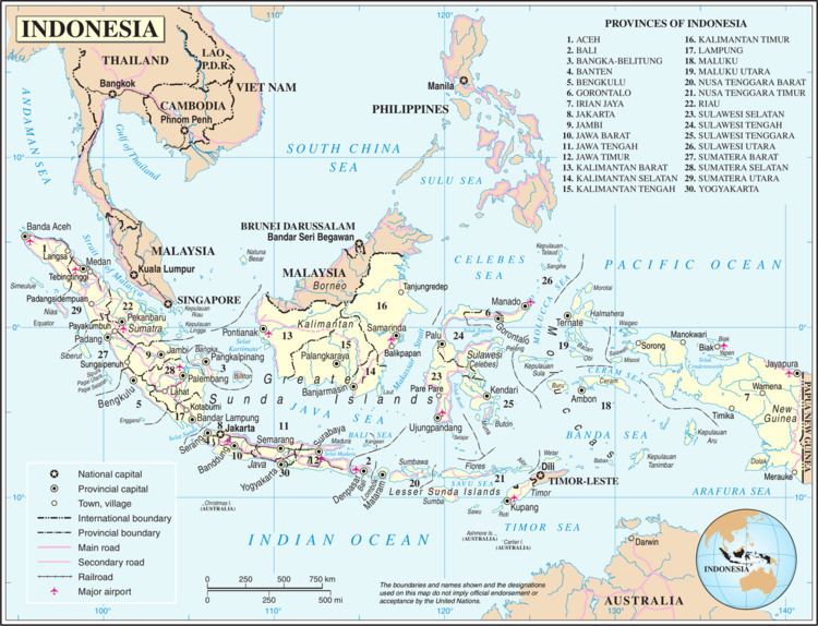
Indonesia is an archipelagic country extending 5,120 kilometres (3,181 mi) from east to west and 1,760 kilometres (1,094 mi) from north to south. According to a geospatial survey conducted between 2007 and 2010 by National Coordinating Agency for Survey and Mapping (Bakosurtanal), Indonesia has 13,466 islands. However, according to earlier survey conducted in 2002 by National Institute of Aeronautics and Space (LAPAN), the Indonesian archipelago has 18,307 islands. According to the CIA factbook, there are 17,508 islands. The discrepancy of the numbers of islands in Indonesia was caused by the earlier survey includes "tidal islands"; sandy cays and rocky reefs that are appeared during low tide and submerged during high tide. There are 8,844 islands have been named according to estimates made by the government of Indonesia, with 922 of those permanently inhabited. It comprises five main islands: Sumatra, Java, Borneo (known as "Kalimantan" in Indonesia), Sulawesi, and New Guinea; two major archipelagos (Nusa Tenggara and the Maluku Islands); and sixty smaller archipelagoes.
Four of the islands are shared with other nations: Borneo is shared with Malaysia and Brunei, Sebatik, located off the eastern coast of Kalimantan, shared with Malaysia, Timor is shared with East Timor, and the newly divided provinces of Papua and West Papua share the island of New Guinea with Papua New Guinea. Indonesia's total land area is 1,919,317 square kilometres (741,052 sq mi).
Included in Indonesia's total territory is another 93,000 square kilometres (35,908 sq mi) of inland seas (straits, bays, and other bodies of water). The additional surrounding sea areas bring Indonesia's generally recognised territory (land and sea) to about 5 million square kilometres. The government, however, also claims an exclusive economic zone, which brings the total to about 7.9 million square kilometres. Latitude = 5.00 S & Longitude = 120.00 E
Because part of New Guinea is Indonesian territory, the country can be said to straddle two continents, Asia and Oceania (or, by another definition, Asia and Sahul). This of course is an arbitrary definition by culture and language on the Asian side, since Indonesia has no territory on the Asian mainland.
Geology
Sumatra, Java, Madura, and Kalimantan lie on the Sunda Shelf and geographers have conventionally grouped them, (along with Sulawesi), as the Greater Sunda Islands. At Indonesia's eastern extremity is western New Guinea, which lies on the Sahul Shelf. Sea depths in the Sunda and Sahul shelves average 200 metres (656 ft) or less. Between these two shelves lie Sulawesi, Nusa Tenggara (also known as the Lesser Sunda Islands), and the Maluku Islands (or the Moluccas), which form a second island group where the surrounding seas in some places reach 4,500 metres (14,764 ft) in depth. The term "Outer Islands" is used inconsistently by various writers but it is usually taken to mean those islands other than Java and Madura.
Borneo is the third largest island in the world and the original vegetation was mostly Borneo lowland rain forests although much of this has been cleared with wildlife retreating to the Borneo montane rain forests inland.
Nusa Tenggara consists of two strings of islands stretching eastward from Bali toward Papua. The inner arc of Nusa Tenggara is a continuation of the chain of mountains and volcanoes extending from Sumatra through Java, Bali, and Flores, and trailing off in the volcanic Banda Islands, which along with the Kai Islands and the Tanimbar Islands and other small islands in the Banda Sea are typical examples of the Wallacea mixture of Asian and Australasian plant and animal life. The outer arc of Nusa Tenggara is a geological extension of the chain of islands west of Sumatra that includes Nias, Mentawai, and Enggano. This chain resurfaces in Nusa Tenggara in the ruggedly mountainous islands of Sumba and Timor.
The Maluku Islands (or Moluccas) are geologically among the most complex of the Indonesian islands. They are located in the northeast sector of the archipelago, bounded by the Philippines to the north, Papua to the east, and Nusa Tenggara to the south. The largest of these islands include Halmahera, Seram and Buru, all of which rise steeply out of very deep seas and have unique Wallacea vegetation. This abrupt relief pattern from sea to high mountains means that there are very few level coastal plains. The islands of North Maluku are the original Spice Islands, a distinct rainforest ecoregion.
Geomorphologists believe that the island of New Guinea, of which Papua is a part, may once have been part of the Australian continent. The break-up and tectonic action created towering, snowcapped mountain peaks lining the island's central east-west spine and hot, humid alluvial plains along the coasts. The New Guinea Highlands range some 650 kilometres (404 mi) east to west along the island, forming a mountainous spine between the north and south coasts. A number of islands off the coast of New Guinea have their own distinctive habitats, including the limestone islands of Biak, in the entrance to the large Cenderawasih Bay at the northwest end of the island.
Mountains and tectonics
Most of the larger islands are mountainous, with peaks ranging between 3,000 and 3,800 metres (9,843 and 12,467 ft) meters above sea level in Sumatra, Java, Bali, Lombok, Sulawesi, and Seram. The country's tallest mountains are located in the Jayawijaya Mountains and the Sudirman Range in Papua. The highest peak, Puncak Jaya (4,884 metres (16,024 ft)), is located in the Sudirman Mountains.
Tectonically, Indonesia is highly unstable. It lies on the Pacific Ring of Fire where the Indo-Australian Plate and the Pacific Plate are pushed under the Eurasian plate where they melt at about 100 km deep. A string of volcanoes stretches from Sumatra to the Banda Sea. While the volcanic ash has resulted in fertile soils, it makes agricultural conditions unpredictable in some areas. A string of volcanoes runs through Sumatra, Java, Bali and Nusa Tenggara, and then loops around through to the Banda Islands of Maluku to northeastern Sulawesi. Of the 400 volcanoes, approximately 150 are active.
Between 1972 and 1991, twenty-nine volcanic eruptions were recorded, mostly on Java. The two most violent volcanic eruptions in modern times occurred in Indonesia; in 1815 Mount Tambora in Sumbawa erupted killing 92,000 and in 1883, Krakatau, erupted killing 36,000.
Time zones
Indonesia is divided into three time zones:
Climate
Lying along the equator, Indonesia's climate tends to be relatively even year-round. Indonesia has two seasons—a wet season and a dry season—with no extremes of summer or winter. For most of Indonesia, the dry season falls between April and October with the wet season between November and March.
Some regions, such as Kalimantan and Sumatra, experience only slight differences in rainfall and temperature between the seasons, whereas others, such as Nusa Tenggara, experience far more pronounced differences with droughts in the dry season, and floods in the wet. Rainfall in Indonesia is plentiful, particularly in west Sumatra, northwest Kalimantan, west Java, and western New Guinea.
Parts of Sulawesi and some islands closer to Australia, such as Sumba and Timor, are drier, however, these are exceptions. The almost uniformly warm waters that make up 81% of Indonesia's area ensure that temperatures on land remain fairly constant. The coastal plains averaging 28 °C (82.4 °F), the inland and mountain areas averaging 26 °C (78.8 °F), and the higher mountain regions, 23 °C (73.4 °F). The area's relative humidity ranges between 70 and 90%.
Winds are moderate and generally predictable, with monsoons usually blowing in from the south and east in June through October and from the northwest in November through March. Typhoons and large scale storms pose little hazard to mariners in Indonesia waters; the major danger comes from swift currents in channels, such as the Lombok and Sape straits.
Indonesia's climate is almost entirely tropical, dominated by the tropical rainforest climate found in every major island of Indonesia, followed by the tropical monsoon climate that predominantly lies along Java's coastal north, Sulawesi's coastal south and east, and Bali, and finally the tropical savanna climate, found in isolated locations of Central Java, lowland East Java, coastal southern Papua and smaller islands to the east of Lombok.
However, cooler climate types do exist in mountainous regions of Indonesia 1300–1500 metres above sea level. The oceanic climate (Köppen Cfb) prevail in highland areas with fairly uniform precipitation year-round, adjacent to rainforest climates, while the subtropical highland climate (Köppen Cwb) exist in highland areas with a more pronounced dry season, adjacent to tropical monsoon and savanna climates.
Above 3000 metres is where cold, subpolar climates dominate and where frost and occasional snow become more commonplace. The subpolar oceanic climate (Köppen Cfc), existing between 3000 and 3500 metres, can be found on the mountain slopes of Indonesia's highest peaks, and serves as a transition between oceanic climates and tundra climates. Tundra climates (Köppen ET), are found anywhere above 3500 metres on the highest peaks of Indonesia, including the permanently snow-capped peaks in Papua. In this climate regime, average monthly temperatures are all below 10 °C, and monthly precipitation is uniform.
Environmental issues
Indonesia's high population and rapid industrialisation present serious environmental issues, which are often given a lower priority due to high poverty levels and weak, under-resourced governance. Issues include large-scale deforestation (much of it illegal) and related wildfires causing heavy smog over parts of western Indonesia, Malaysia and Singapore; over-exploitation of marine resources; and environmental problems associated with rapid urbanisation and economic development, including air pollution, traffic congestion, garbage management, and reliable water and waste water services.
Deforestation and the destruction of peatlands make Indonesia the world's third largest emitter of greenhouse gases. Habitat destruction threatens the survival of indigenous and endemic species, including 140 species of mammals identified by the World Conservation Union (IUCN) as threatened, and 15 identified as critically endangered, including the Sumatran Orangutan.
In 1970, 15% of Indonesians lived in cities compared to over 30% today, and this increases pressure on the urban environment. Industrial pollution is increasing, particularly in Java, and the increasing affluence of the growing middle class drives a rapid increase in the number of motor vehicles and associated emissions. Garbage and waste water services are being placed under increasing pressure. Reliance on septic systems or effluent disposal in open canals and river systems remains the norm, and is a major polluter of water resources. Very few Indonesians have access to safe drinking water and must boil water before use.
The geographical resources of the Indonesian archipelago have been exploited in ways that fall into consistent social and historical patterns. One cultural pattern consists of the formerly Indianized, rice-growing peasants in the valleys and plains of Sumatra, Java, and Bali, another cultural complex is composed of the largely Islamic coastal commercial sector, a third, more marginal sector consists of the upland forest farming communities which exist by means of subsistence swidden agriculture. To some degree, these patterns can be linked to the geographical resources themselves, with abundant shoreline, generally calm seas, and steady winds favouring the use of sailing vessels, and fertile valleys and plains—at least in the Greater Sunda Islands—permitting irrigated rice farming. The heavily forested, mountainous interior hinders overland communication by road or river, but fosters slash-and-burn agriculture.
Area and boundaries
Area:
total land area: 1,904,569 km2 (land: 1,811,569 km2 (699450 mi2), inland water: 93,000 km2) (35,907 mi2)
territorial area: 5,193,250 km2
total area (including exclusive economic zone): around 7.9 million km2
Land boundaries:
total: 2,958 kilometres (1,838 mi)
border countries: Malaysia 1,881 kilometres (1,169 mi), Papua New Guinea 824 kilometres (512 mi), East Timor 253 kilometres (157 mi)
Other nearby countries: India NW of Aceh, Australia, Singapore, Philippines, Brunei.
Coastline: 54,716 km (33,999 mi)
Maritime claims: measured from claimed archipelagic baselines
territorial sea: 12 nmi (13.8 mi; 22.2 km)
exclusive economic zone: 200 nmi (230.2 mi; 370.4 km)
Elevation extremes:
lowest point: Indian Ocean 0 m(sea surface level), Wetar Basin in east of Banda Sea at -7,440 m (northwest of Tanimbar Islands & southeast of Ceram Island), where subduction zone is
highest point: Puncak Jaya (also known as Carstensz Pyramid) 4,884 m
Land use:
arable land: 12.97%
permanent crops: 12.14%
other: 74.88% (2013)
Irrigated land: 67,220 km2 (2005) (25,953 mi2)
Total renewable water resources: 2,019 km3 (2011) (484 mi3)
Freshwater withdrawal (domestic/industrial/agricultural):
total: 113.3 km3/yr (11%/19%/71%)
per capita: 517.3 m3/yr (2005)
Natural resources: petroleum, tin, natural gas, nickel, timber, bauxite, copper, fertile soils, coal, gold, silver