
Age of rock 57,000 years Last eruption 1967 Prominence 2,850 m | Mountain type Stratovolcano/Caldera Elevation 2,850 m | |
 | ||
Listing Ultra-prominent peak, Ribu Similar Krakatoa, Mount Rinjani, Mount Pinatubo, Mount Pelée, Mount St Helens | ||
Mount tambora the year without a summer
Mount Tambora is an active stratovolcano which is a peninsula of and the highest peak on the island of Sumbawa in Indonesia. Sumbawa is flanked both to the north and south by oceanic crust, and Tambora was formed by the active subduction zone beneath it. This raised Mount Tambora as high as 4,300 m (14,100 ft), making it one of the tallest peaks in the Indonesian archipelago in the 18th century. After a large magma chamber inside the mountain filled over the course of several decades, volcanic activity reached a historic climax in the eruption of 10 April 1815. This eruption had a volcanic explosivity index (VEI) of 7, the only unambiguously confirmed VEI-7 eruption since the Lake Taupo eruption in about AD 180. (The 946 eruption of Paektu Mountain might also have been VEI-7.) Tambora's last eruption was in 1967. It was rated VEI-0.
Contents
- Mount tambora the year without a summer
- Map of Mount Tambora Kawinda Toi Tambora Bima West Nusa Tenggara Indonesia
- Volcanoes mount tambora vs krakatoa
- Geographical settingEdit
- FormationEdit
- Eruptive historyEdit
- 1815 eruptionEdit
- Archaeological workEdit
- EcosystemEdit
- Caldera floorEdit
- Monitoring TamboraEdit
- References
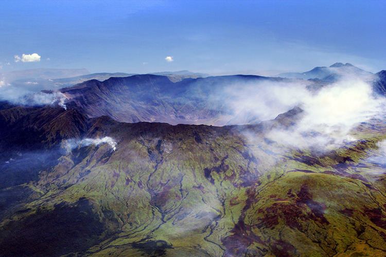
Map of Mount Tambora, Kawinda Toi, Tambora, Bima, West Nusa Tenggara, Indonesia
With an estimated ejecta volume of 160 km3 (38 cu mi), Tambora's 1815 outburst is the largest volcanic eruption in recorded history. The explosion was heard on Sumatra, more than 2,000 km (1,200 mi) away. Heavy volcanic ash falls were observed as far away as Borneo, Sulawesi, Java, and the Maluku Islands. Most of the deaths from the eruption were from starvation and disease, as the eruptive fallout ruined agricultural productivity in the local region. The death toll was at least 71,000 people, of whom 11,000–12,000 were killed directly by the eruption; the oft-cited figure of 92,000 people killed is believed to be an overestimate.
The eruption caused global climate anomalies that included the phenomenon known as "volcanic winter": 1816 became known as the "Year Without a Summer" because of the effect on North American and European weather. Crops failed and livestock died in much of the Northern Hemisphere, resulting in the worst famine of the 19th century.
During an excavation in 2004, a team of archaeologists discovered cultural remains buried by the 1815 eruption. They were kept intact beneath the 3-metre-deep pyroclastic deposits. At the site, dubbed the "Pompeii of the East", the artifacts were preserved in the positions they had occupied in 1815.
Volcanoes mount tambora vs krakatoa
Geographical settingEdit
Mount Tambora is on Sumbawa Island, part of the Lesser Sunda Islands. It is a segment of the Sunda Arc, a string of volcanic islands that forms the southern chain of the Indonesian archipelago. Tambora forms the Sanggar peninsula on Sumbawa. At the north of the peninsula is the Flores Sea, and at the south is Saleh Bay, 86 km (53 mi) long and 36 km (22 mi) wide. At the mouth of Saleh Bay is a 30,000-hectare islet called Moyo (Indonesian: Pulau Moyo) which has a guest shelter or luxurious resort where celebrities such as Princess Diana once stayed.
Besides its interest for seismologists and volcanologists, who monitor the mountain's activity, Mount Tambora is an area of scientific studies for archaeologists and biologists. It also attracts tourists for hiking and wildlife activities. The two nearest cities are Dompu and Bima. Three concentrations of villages are around the mountain slope. At the east is Sanggar village, to the northwest are Doro Peti and Pesanggrahan villages, and to the west is Calabai village.
Three ascent routes are used to reach the caldera. The first route starts from Doro Mboha village south of the mountain, and follows a paved road through a cashew plantation until it reaches 1,150 m (3,770 ft) above sea level. The end of this route is the southern part of the caldera at 1,950 m (6,400 ft), reachable by a hiking track. This location is usually used as a base camp to monitor the volcanic activity, because it takes only one hour to reach the caldera. The second route is southwest of the mountain, starting from Doro Peti village; the Tambora volcanic monitoring station is in Doro Peti. The third route starts from Pancasila village northwest of the mountain, and passes through a coffee plantation. Using the third route, the caldera is accessible only by foot. The highest point of Tambora is on a hill near the western rim of the caldera.
In August 2011, the alert level for the volcano was raised from level I to level II after increasing activity was reported in the caldera, including earthquakes and smoke emissions.
FormationEdit
Tambora is 340 km (210 mi) north of the Java Trench system and 180–190 km (110–120 mi) above the upper surface of the active north-dipping subduction zone. Sumbawa island is flanked to both the north and south by the oceanic crust. The convergence rate is 7.8 cm (3.1 in) per year. Tambora is estimated to have formed around 57,000 years ago. Depositing its strata has drained off a large magma chamber inside the mountain. The Mojo islet was formed as part of this geological process in which Saleh Bay, collapsing into the caldera of the drained magma chamber, first appeared as a sea basin, about 25,000 years ago.
According to a geological survey before the 1815 eruption, Tambora had the shape of a typical stratovolcano, with a high symmetrical volcanic cone soaring up to 4,300 m (14,100 ft) above the sea level, and a single central vent. The diameter at the base is 60 km (37 mi). The central vent emitted lava frequently, which cascaded down a steep slope.
Since the 1815 eruption, the lowermost portion contains deposits of interlayered sequences of lava and pyroclastic materials. The 1 to 4m thick lava flows constitute about 40% of the layers' thickness. Thick scoria beds were produced by the fragmentation of lava flows. Within the upper section, the lava is interbedded with scoria, tuffs, and pyroclastic flows and falls. At least 20 subsidiary or parasitic cones are known. Some of them have names: Tahe, 844 m (2,769 ft); Molo, 602 m (1,975 ft); Kadiendinae; Kubah, 1,648 m (5,407 ft); and Doro Api Toi. Most of these parasitic cones have produced basaltic lavas.
Eruptive historyEdit
Radiocarbon dating has established the dates of three of Mount Tambora's eruptions before the 1815 eruption. The magnitudes of these eruptions are unknown. The estimated dates are 3910 BC ± 200 years, 3050 BC and 740 AD ± 150 years. They were all explosive central vent eruptions with similar characteristics, but the 740 AD eruption had no pyroclastic flows.
In 1812, Mount Tambora entered a period of high activity, with its climactic eruption being the catastrophic explosive event of April 1815.
Mount Tambora is still active. Minor lava domes and flows have been extruded on the caldera floor during the 19th and 20th centuries. The last eruption was recorded in 1967. However, it was a very small, non-explosive eruption (VEI = 0).
There were reports of a similarly small eruption in 2011.
1815 eruptionEdit
The 1815 VEI-7 eruption had a total tephra ejecta volume of 160 km3 (38 cu mi). It was an explosive central vent eruption with pyroclastic flows and a caldera collapse, causing tsunamis and extensive land and property damage. It had a long-term effect on global climate. This activity ceased on 15 July 1815. Follow-up activity was recorded in August 1819 consisting of a small eruption (VEI = 2) with flames and rumbling aftershocks, and was considered to be part of the 1815 eruption sequence. Around 1880 ± 30 years, Tambora went into eruption again, but only inside the caldera. Small lava flows and lava dome extrusions were formed. This eruption (VEI = 2) created the Doro Api Toi parasitic cone inside the caldera. This was the largest and most violent eruptions in the last 5000 years along with the Hatepe eruption of Lake Taupo at around 180 AD and the Tianchi eruption of Baekdu around 1000. The 1815 eruption was the worst eruption in 2,000 years.
Archaeological workEdit
Archaeological evidence indicates that the 1815 eruption of Mount Tambora wiped out a culture on Sumbawa.
EcosystemEdit
A scientific team led by a Swiss botanist, Heinrich Zollinger, arrived on Sumbawa in 1847, making an ascent to the eastern rim of the caldera with the help of a native team. Zollinger's mission was to study the eruption scene and its effects on the local ecosystem. He was the first person to climb to the summit after the eruption. It was still covered by smoke. As Zollinger climbed up, his feet sank several times through a thin surface crust into a warm layer of powder-like sulphur. Some vegetation had reestablished itself and he saw a few trees on the lower slope. A Casuarina forest was noted at 2,200–2,550 m (7,220–8,370 ft). Several Imperata cylindrica grasslands were also found.
Resettlement of the mountain began in 1907. A coffee plantation was started in the 1930s on the northwestern slope of the mountain, in the village of Pekat. A dense rain forest, dominated by the pioneering tree Duabanga moluccana, had grown at an altitude of 1,000–2,800 m (3,300–9,200 ft). It covers an area up to 80,000 ha (200,000 acres). The rain forest was explored by a Dutch team, led by Koster and de Voogd, in 1933. From their accounts, they started their journey in a "fairly barren, dry and hot country", and then they entered "a mighty jungle" with "huge majestic forest giants". At 1,100 m (3,600 ft), they entered a montane forest. Above 1,800 m (5,900 ft), they found Dodonaea viscosa dominated by Casuarina trees. On the summit, they found sparse Anaphalis viscida and Wahlenbergia.
In 1896, 56 species of birds were found, including the crested white-eye. Twelve further species were found in 1981. Several other zoological surveys followed, and found other bird species on the mountain, resulting in over 90 bird species discovered on Mount Tambora. Yellow-crested cockatoos, Zoothera thrushes, hill mynas, green junglefowl and rainbow lorikeets are hunted for the cagebird trade by the local people. Orange-footed scrubfowl are hunted for food. This bird exploitation has resulted in a decline in the bird population. The yellow-crested cockatoo is nearing extirpation on Sumbawa island.
Since 1972, a commercial logging company has been operating in the area. The logging company holds a timber-cutting concession for an area of 20,000 ha (49,000 acres), or 25% of the total area. Another part of the rain forest is used as a hunting ground. In between the hunting ground and the logging area, there is a designated wildlife reserve where deer, water buffalos, wild pigs, bats, flying foxes, and various species of reptiles and birds can be found.
In 2015 the conservation area protecting the mountain's ecosystem has been upgraded to the status of national park.
Caldera floorEdit
An ecosystem has developed in the caldera formed by the 1815 eruption. This ecosystem has been largely uninfluenced by human beings because of its isolation.
Monitoring TamboraEdit
Indonesia's population has been increasing rapidly since the 1815 eruption. As of 2006, the population of Indonesia has reached 222 million people, of which 130 million are concentrated on Java. A contemporary volcanic eruption as large as Tambora's 1815 eruption would cause catastrophic devastation with likely many more fatalities. Therefore, volcanic activity in Indonesia is continuously monitored, including that of Mount Tambora.
Seismic activity in Indonesia is monitored by the Directorate of Volcanology and Geological Hazard Mitigation, Indonesia. The monitoring post for Mount Tambora is located at Doro Peti village. They focus on seismic and tectonic activities by using a seismograph. Since the 1880 eruption, there has been no significant increase in seismic activity. However, monitoring is continuously performed inside the caldera, especially around the parasitic cone Doro Api Toi.
The directorate has defined a hazard mitigation map for Mount Tambora. Two zones are declared: the dangerous zone and the cautious zone. The dangerous zone is an area that will be directly affected by an eruption: pyroclastic flow, lava flow and other pyroclastic falls. This area, including the caldera and its surroundings, covers up to 58.7 km2 (22.7 sq mi). Habitation of the dangerous zone is prohibited. The cautious zone includes areas that might be indirectly affected by an eruption: lahar flows and other pumice stones. The size of the cautious area is 185 km2 (71 sq mi), and includes Pasanggrahan, Doro Peti, Rao, Labuan Kenanga, Gubu Ponda, Kawindana Toi and Hoddo villages. The river Guwu at the southern and northwest part of the mountain is also included in the cautious zone.