
Country Language spoken Capital | Population 3.551 million (2010) Area 129,066.64 km2 Governor Mukmin Faisyal | |
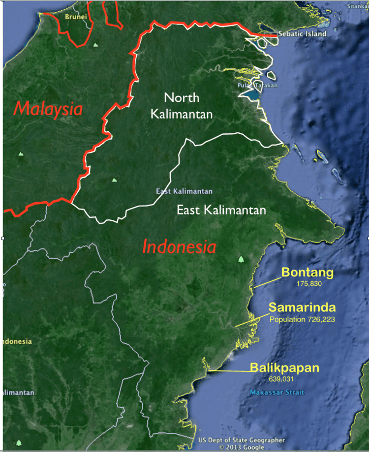 | ||
Map of East Kalimantan
East Kalimantan (Indonesian: Kalimantan Timur) is a province of Indonesia. Its territory comprises the eastern portion of Borneo. It has a population of about 3.5 million, and its capital is Samarinda.
Contents
- Map of East Kalimantan
- Pulau maratua east kalimantan paradise
- History
- Geography
- Climate
- Temperature and humidity
- Rainfall and wind conditions
- Administrative divisions
- Ecology
- Economy
- Tourist sites
- North Kalimantan Province
- Ethnicity
- Language
- References
East Kalimantan has a total area of 129,066.64 square kilometres (49,832.91 sq mi) and is the second least densely populated province in Kalimantan. The majority of the region shares a maritime border to the east with West Sulawesi and North Sulawesi; its coastline faces the Makassar Strait and the Celebes Sea. Its former northernmost region is now North Kalimantan; to its south, East Kalimantan borders the South Kalimantan province. The province bordered Sabah before the split, but still borders Sarawak.
East Kalimantan is now divided into six regencies and three cities. Awang Faroek Ishak is its governor and Mukmin Faisal is its vice governor.
Pulau maratua east kalimantan paradise
History
East Kalimantan was once mostly covered by tropical rainforest. There are several kingdoms in East Kalimantan, including the Kingdom of Kutai (Hindu), Sultanate of Kutai ing Martadipura, and the Sultanate of Pasir. East Kalimantan region include Pasir, Kutai, Berau and also Karasikan (Buranun / pre-Sultanate of Sulu) claimed as conquered territory Suryanata Maharaja, the governor of Majapahit in the State Dipa (which is located in the Great Temple in Amuntai) until 1620 in the Sultanate of Banjar. Between the years 1620-1624, kingdoms in East Kalimantan turned into an area influence of the Sultanate of Sultan Alauddin Makassar, before the Bungaya agreement. According to the Hikayat Banjar, the Sultan of Makassar never borrowed land for trade covers an area east and southeast of Borneo to the Sultan Mustain Billah of Banjar when Kiai Martasura sent to Makassar and entered into an agreement with the Sultan Tallo I Mangngadaccinna Daeng I Ba'le 'Sultan Mahmud Karaeng Pattingalloang, which became Mangkubumi and principal advisor to the Sultan Muhammad Said, King of Gowa in 1638-1654 and also in-law of Sultan Hasanuddin, which will make the East Kalimantan region as a place to trade for the Sultanate of Makassar (Gowa-Tallo), since that began to arrive people from South Sulawesi. However, based on the agreement between the Sultanate of Banjar and the Dutch East India Company (VOC) in 1635, VOC help Banjar restore lands in East Kalimantan into spheres of influence of the Sultanate of Banjar. It is embodied in the Bungaya agreement, that the Sultanate of Makassar are not allowed to trade up to the east and the north Borneo
In accordance tracts January 1, 1817, Sultan Sulaiman of Banjar handed East Kalimantan, Central Kalimantan, part of West and South Kalimantan (including Banjarmasin) to the Dutch East Indies. On May 4, 1826, Sultan Adam al-wathiq Billah of Banjar reaffirmed the handover East Kalimantan, Central Kalimantan, part of West and South Kalimantan to the Dutch East Indies colonial administration. In 1846, the Dutch began to put a Resident Assistant in East Borneo at Samarinda (now the province of East Kalimantan and the eastern part of South Kalimantan) named H. Von Dewall. East Kalimantan is then part of the Dutch East Indies.
East Kalimantan Province in addition to a unity administration, as well as ecological and historical unity. East Kalimantan as the administrative area was established based on the Law No. 25 of 1956 with the first governor beingis APT Pranoto.
Geography
East Kalimantan region comprising land area of 127,267.52 square kilometers and comprehensive ocean management 25 656 km², located between 113 ° 44 'and 119 ° 00' east longitude, and between 2 ° 33 'North latitude and 2 ° 25' South Latitude. With the development and regional divisions, East Kalimantan, which is the third largest province after Papua and Central Kalimantan, is divided into sevendistricts, three cities, 103 districts and 1,026 villages / kelurahan. Tujuh the district is the capital of Paser Land Grogot, Kutai Barat with capital Sendawar, Kukar with capital Tenggarong, Kutai Timur to the capital Sangatta, Berau with capital Tanjung Redeb, Penajam Penajam Paser Utara with capital and with capital Mahakam Ulu Long Bagun (a division of Kutai Barat). While the three Municipalities are Balikpapan, Samarinda, Bontang. East Kalimantan is one of the main gates in the eastern part of Indonesia. The area is also known as a storehouse of timber and mining has hundreds of rivers are scattered in almost all districts / cities and is the main means of transportation in addition to land transport, with the longest river Mahakam.Provinsi River East Kalimantan is located in the most eastern island of Borneo. Precisely this province is directly adjacent to the north of North Borneo, the Celebes Sea and the Makassar Strait in the east, South Kalimantan in the South, and West Kalimantan, Central Kalimantan and Malaysia in the west. East Kalimantan mainland can not be separated from the hills are almost all districts. The number of lakes in the province is also quite a lot of about 18 pieces. Most lakes are located in the Kutai regency with the most extensive lake that is Lake Semayang and Melintang, each of which has an area of 13,000 ha and 11,000 ha.
Climate
Such a climate of Indonesia in general, East Kalimantan tropical climate and has two seasons, dry and rainy seasons. The dry season usually occurs in May to October, while the rainy season in November to April. This situation continued every year interspersed with transitional season in certain months. Moreover, because of its location on the equator, the climate in East Kalimantan are also affected by wind monsoon, monsoon wind is November–April west and east monsoon winds from May to October. In recent years, the situation in East Kalimantan season is sometimes erratic. In the months that it is supposed to rain, there is no rain at all, or vice versa in the months that should be dry it rains for a much longer time.
Temperature and humidity
Temperatures somewhere high and low are determined by the area of the ocean surface and the distance from the beach. In general, East Kalimantan hot climates with temperatures in 2013 ranged from 21.6 ⁰C in Berau October to 35.6 ⁰C in Berau in September. The average temperature is lowest and the highest 22,1⁰C 35,1⁰C occur in Berau. Aside from being a tropical area with extensive forests, in 2013 the average humidity between 83-87 percent of East Kalimantan. The lowest air humidity observed by the meteorological station Samarinda happens in a few months with 82 percent humidity. While the highest occurred in Berau in February with 91 percent humidity.
Rainfall and wind conditions
Rainfall in East Kalimantan region varies by month and location of monitoring stations. Average highest rainfall recorded at the Meteorological Station Berau amounted to 245.1 mm and the lowest for the year 2013 was recorded at the Meteorological Station Samarinda is 237.8 mm. At some monitoring stations monitor wind conditions in East Kalimantan in 2013. Observations show that wind speeds between 3 and 4 knots. The highest wind speed was 4 knots in Balikpapan and Berau, while the lowest was 3 knots in Samarinda.
Administrative divisions
Until 2012, East Kalimantan was divided into ten regencies (kabupaten) and four cities (kota). On 22 October 2012, the Indonesian House of Representatives agreed to the creation of a new province out of the four most northerly of the Regencies in East Kalimantan, namely Malinau Regency, Nunukan Regency, Tana Tidung Regency and Bulungan Regency, together with one city, Tarakan. Accordingly, these were split off to form the new province of North Kalimantan on 25 October 2012, leaving the following regencies and cities to comprise the reduced East Kalimantan:
Ecology
Illegal logging has removed much of the original forests of the province. Less than half the original forest remains in places such as the Kayan Mentarang the Kutai national parks.
The projects that supports tropical rainforest conservation includes a WWF project and Samboja Lestari lodge, one of Borneo Orangutan Survival Foundation's reforestation and orangutan rehabilitation projects.
Economy
East Kalimantan's economy heavily depends on earth resources such as oilfield exploration, natural gas, coal and gold. Balikpapan has an oil refinery plant that was built by Dutch governance before World War II, destroyed during World War II, and rebuilt after Indonesian independence.
Other developing economic sectors include agriculture and tourism.
Obstacles to economic development include a lack of transportation infrastructure. Transportation depends on traditional boats connecting coastal cities and areas along main river, Mahakam River.
In 2012, Russia's state railway firm Joint Stock Company (JSC) signed a Memorandum of Understanding with the East Kalimantan Governor over railway lines to transport coal and other freight. The first stage will connect an area near Balikpapan port to West Kutai Regency in a 183-kilometer line and is estimated to cost about $1.8 billion. It will commence in 2013 and by 2017 it is hoped that it carry 20 million tons of coal annually. The second phase will connect a line to Murung Raya in Central Kalimantan with a 60 kilometer line, which will cost an estimated $600 million.
Several oil fields have been discovered in the Mahakam River Delta including Attaka, Badak (1971), Semberah, Nilam, Sanga Sanga, Bekapai (1972), Handil (1974), Samboja, Jakin and Sepinggan. The Handil, Badak and Bekapai fields are anticline structural traps with oil reservoir sandstones between 450 and 2900 m. The delta is in the Kutei basin, bounded by the Mankalihat and Paternoster carbonate arch, containing Eocene shales overlain by Oligocene fluvial deposits during marine regression, culminating in the formation of the delta in the late Miocene.
Tourist sites
At Kutai Regencies, There's a Bukit Bangkirai National park with their famously 30m canopy bridges that took 45 min driving by cars from Balikpapan city and Great Stone Wall (Batu Dinding) located at km.41 and took between 30 min with cars from Balikpapan city and another 15 min by walking to the spot. Orangutan sanctuary, crocodile breeding park, and Botanical Garden located at Balikpapan city with some few other beach spots for tourism. At North Penajam Paser Regencies, there's a Deer Sanctuary and its also a waterfall at Riko, and another two waterfalls near ex. PT. International Timber Coorporation Indonesia area and another one dept to the jungle near Sepaku with located secretly by peoples to keep the waterfall beautiful and naturalized without any human or tourism damages. There also Mount Parung located at Sepaku as the Highest Mountain in the Area with a big cave and pre-historic stone formation at the peak of it. making In addition to Derawan Islands, East Kalimantan has a unique natural site, Labuan Cermin Lake at Biduk-biduk district which features fresh water on top with about 2 meters thickness and sea water underneath it. Both fresh water fish and sea water fish live in the lake inhabiting their respective habitat layer. "Cermin" means mirror in Indonesian language and the lake was named so due to the clarity of the water.
North Kalimantan Province
North Kalimantan was formally inaugurated as the 34th province of Indonesia on April 15, 2013. The new province was previously part of East Kalimantan Province and Irianto Lambrie will be acting as the governor of it until a new governor is chosen by their people in an election.
Ethnicity
The majority ethnic group in East Kalimantan is the Javanese (30.24%) which is spread in almost all regions, especially the transmigration areas to urban areas. The second largest ethnic namely Bugis (20.81%), which occupy many coastal areas and urban areas. The third largest Ethnicity is Banjar (12.45%) were quite dominant in the city of Samarinda and Balikpapan. East Kalimantan is a major destination of origin of Java, Sulawesi and South Kalimantan.
In the fourth place is the Dayak (9.94%), which occupies the interior part of the province. Kutai (7.80%) which inhabit Kutai, East Kutai and Kutai Barat was fifth. In the sixth to ten consecutive namely Toraja (2.21%), Paser (1.89%), Sunda (1.57%), Madura (1.32%) and Auto Buton (1.25%) and other tribes from various regions in Indonesia.
Language
People in East Kalimantan generally use the Indonesian language and the Banjar language. Distribution of East Kalimantan to the Banjar language because of the large number of overseas South Kalimantan Banjar ethnic origin so the language Banjar used as a daily language, especially in the city of Samarinda and Balikpapan. Speakers Javanese and Bugis language is also quite large in East Kalimantan for many migrants from Java and Sulawesi inhabiting East Kalimantan.
Other languages spoken people in East Kalimantan is Kutai, Paser language, language Tidung, Berau language, language Tunjung, Bahau language, the language and the language Modang Lundayeh.