
Length 46.4 km | ||
 | ||
History: 1971 (first section open)2003 (final section open)2005 (freeway completed) North end: Stoney Trail near Balzac | ||
Deerfoot trail in calgary alberta canada
Deerfoot Trail is a major freeway in Calgary, Alberta, Canada, linking suburbs to downtown via Memorial Drive and connecting Calgary to Red Deer, Edmonton, and Lethbridge. The 46.4-kilometre (28.8 mi) freeway is a segment of Alberta Highway 2 and begins near De Winton where it splits from Macleod Trail (Highway 2A) and crosses the Bow River into city limits. It continues north across Stoney Trail before turning west to cross the Bow River again, after which it merges with two expressways, Anderson Road and Bow Bottom Trail. It veers north to Glenmore Trail, then sharply turns east to cross the Bow River a third time before curving back to the north. After interchanges with Memorial Drive and Highway 1 (Trans-Canada Highway), the freeway passes Calgary International Airport en route to its terminus at a second interchange with Stoney Trail at the city limit of Calgary, from which it continues north in Rocky View County to Red Deer and Edmonton as the Queen Elizabeth II Highway.
Contents
- Deerfoot trail in calgary alberta canada
- Map of Deerfoot Trail Calgary AB Canada
- Driving on deerfoot trail in calgary canada
- Overview
- South Calgary
- North Calgary
- Traffic and collisions
- Interchanges
- Predecessor highways
- Early plans and construction
- Completion
- Since completion
- Future
- References
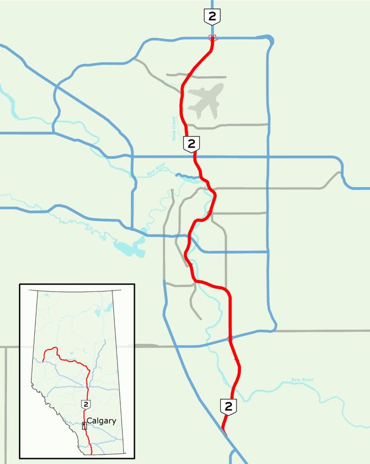
Map of Deerfoot Trail, Calgary, AB, Canada
The first of five segments to be constructed opened in 1971, with subsequent sections opening in 1975, 1980, 1982 and 2003; Deerfoot became the first major freeway in Calgary after completion of the final south Calgary interchange in 2005. Planners had intended to keep Deerfoot entirely west of the Bow River on a relatively direct path through south Calgary, but political pressure forced the freeway to the east away from existing residential areas, and later, out of Fish Creek Provincial Park. Originally called Blackfoot Trail Freeway, the route was renamed in 1974 to honour Deerfoot, a late 19th century Siksika Nation (Blackfoot) long distance runner known for his exceptional speed.
Near downtown, traffic levels continue to increase after exceeding 165,000 vehicles per day in 2012, making Deerfoot the busiest road in Western Canada. It carries more than twice the volume for which it was designed and traffic jams are frequent within the bounds of Stoney Trail; in north Calgary the freeway is hampered by the proximity of its interchanges to each other, and at a pair of interchanges in south Calgary it narrows from six total lanes to four. In an effort to improve traffic flow and a collision rate higher than any other major road in the city, Alberta and Calgary began a joint study in 2016 that will present short and long-term options for upgrades, while all existing plans have either been deferred or scrapped.
Driving on deerfoot trail in calgary canada
Overview
As a segment of Highway 2, Deerfoot Trail is a core route of the National Highway System and a key international corridor. It is also identified as a skeletal road by the city of Calgary, a limited-access route important for long distance travellers, and is the only route that stretches the entire length of the city from north to south. From its split with Highway 2A (Macleod Trail) near the hamlet of De Winton, it runs north to Stoney Trail at Calgary's northern city limit where it becomes the Queen Elizabeth II Highway. The freeway roughly bisects the city; its southern half follows the Bow River from Downtown Calgary to the southern city limit. Initially Deerfoot is on the east side, then crosses to the west bank, and finally back to the east before veering west at Inglewood with the river and Memorial Drive toward downtown. Most of the northern half parallels Nose Creek, a tributary of the Bow.
Deerfoot is a divided freeway for its entire 46.4-kilometre length, ranging from four to eight lanes wide. The northbound and southbound lanes are separated by an approximately 15-metre (49 ft) wide depressed grass median near De Winton, which narrows and becomes a combination of Jersey and constant-slope barriers through most of south Calgary before returning to grass of varying widths from 17 Avenue SE to the north terminus. In north Calgary the grass median is supplemented by 10.75 km (6.7 mi) of high-tension cable barriers (HTCB) that were added in 2007, virtually eliminating the risk of serious median collisions. It was the first major HTCB installation in Canada. The freeway has a posted speed limit of 110 km/h (68 mph) from its origin at Highway 2A until just after the first Bow River crossing, after which the limit is reduced to 100 km/h (62 mph) for the next 34 km (21 mi) through most of Calgary until Beddington Trail in the northeast where the limit returns to 110 km/h. The entire route is paved with asphalt, except for a 12 km (7.5 mi) concrete section in south Calgary.
Alberta Transportation has signed a contract with Carmacks Enterprises for maintenance of Deerfoot Trail from Stoney Trail in south Calgary to the northern city limit. The province intends to return control of the freeway to the city, but it is desirable for the city to avoid the significant maintenance and rehabilitation costs have the road remain under provincial control for as long as possible. Former Calgary mayor Rod Sykes said, "I wouldn’t take on the problems of the Deerfoot if I were at City Hall now."
South Calgary
Deerfoot Trail begins as a rural freeway near De Winton where two lanes fork to the northeast from Macleod Trail and descend across Dunbow Road toward the Bow River. It crosses the river on twin 236-metre (774 ft) bridges constructed over an environmentally sensitive area of the valley. Rising from the river, the freeway enters Calgary limits and its southern suburban neighbourhoods of Cranston and Seton to which access is provided by a partial cloverleaf interchange. A major junction at the Stoney Trail ring road immediately follows, with signage recommending that traffic destined for the International Airport, Edmonton, and Medicine Hat use eastbound Stoney Trail as a bypass. Continuing north as an eight lane freeway, Deerfoot passes between the communities of McKenzie Lake and McKenzie Towne, crossing 130 Avenue SE to the south terminus of Barlow Trail. It then reduces to six lanes, curving to the west through the neighbourhoods of Douglasdale and Douglasglen across the Bow River on the Ivor Strong Bridge, named after John Ivor Strong who served as Chief Commissioner for Calgary until 1971.
Immediately after the river, Deerfoot merges with the major routes of Anderson Road and Bow Bottom Trail, often a point of congestion at rush hour. In both directions, traffic through the outdated interchange is reduced from three lanes to two. The freeway curves north along the river's west bank to cross Southland Drive, paralleling Blackfoot Trail near the community of Acadia. North of Acadia, the freeway bisects a large area of commercial development for several kilometres before reaching a major interchange at Glenmore Trail. The interchange is generally identified as the second of two major congestion points on Deerfoot in south Calgary, the so called "Glenmore squeeze", where traffic is reduced to two lanes each way over Glenmore. Deerfoot turns sharply to the east and again crosses the Bow River on the Calf Robe Bridge, named after a Sikiska elder. Veering back to the north, it follows the river's east bank across Peigan Trail to a partial cloverleaf interchange at 17 Avenue SE, passing the neighbourhoods of Dover and Southview. Deerfoot meets Memorial Drive, a major freeway spur into downtown, near Pearce Estate Wetland, Calgary Zoo and the Max Bell Centre, and continues into north Calgary while the Bow River turns west toward downtown.
North Calgary
In north Calgary, the freeway climbs along the east side of Nose Creek, a tributary of the Bow River. From Memorial Drive, it passes the Vista Heights neighbourhood to 16 Avenue NE (Highway 1/Trans-Canada Highway); this section has been largely unchanged since its completion in 1975. The six lane freeway enters light commercial development north of 32 Avenue NE. Access to Huntington Hills and Deerfoot Mall are then provided by an interchange at 64 Avenue NE. Beddington Trail splits to the northwest from Deerfoot, following Nose Creek into a large residential area of north Calgary that includes the neighbourhoods of Country Hills, Panorama Hills, and Hidden Valley. The speed limit on Deerfoot increases to 110 km/h as development tapers in an increasingly rural area of north Calgary. After West Nose Creek Park, an interchange with Airport Trail serves as the primary access for Calgary International Airport, and to the west, the neighbourhood of Harvest Hills via 96 Avenue NE. North of Airport Trail, the freeway curves northeast through light commercial areas across Country Hills Boulevard and ends at an interchange with Stoney Trail. It continues north to Airdrie as the Queen Elizabeth II Highway.
Traffic and collisions
Deerfoot Trail is Alberta's busiest highway by a significant margin over Glenmore Trail, with peak daily congestion lasting as many as four hours. Its most travelled stretch is between Memorial Drive and 16 Avenue NE (Trans-Canada Highway) as traffic from Calgary's northern and eastern suburbs converge to travel via Memorial Drive into downtown, in addition to traffic transiting the city and other intra-city trips. The freeway was designed to carry approximately 65,000 vehicles per day but as of 2015 carries almost triple that volume near Memorial Drive. In late 2013, the southeastern segment of Stoney Trail was opened to traffic. In conjunction with the northeast portion which opened in 2009, it formed a full eastern bypass of Calgary providing an alternate route for traffic transiting the city. Traffic levels on Deerfoot Trail decreased in the year following the opening, but have since risen to pre-Stoney levels. In a 2016 study, Calgary ranked tenth in traffic congestion among major Canadian cities, with drivers spending nearly 16 hours of the year in standstill traffic.
The excessive volume on Deerfoot Trail is a contributing factor to the 10,000 collisions recorded between 2002 and 2007, including 24 fatalities. Constable Jeff Klatt of the Calgary Police Service stated that there is a "consensus among police officers that it’s dangerous to do traffic stops" on Deerfoot Trail. A 1993 incident in which a stolen vehicle struck and killed a police officer on Deerfoot Trail was the catalyst for the Calgary Police Service's acquisition of a helicopter. 2013 statistics confirmed that Deerfoot Trail had more crashes and traffic jams than any other road in Calgary. Deerfoot has many entrances and exits in close proximity which exacerbates problems, but some have attributed a portion of the congestion to driver error. Constable Jim Lebedeff of the Calgary Police Service stated, "a lot of people don’t understand, or don’t want to understand, how to merge properly.” 30% of respondents to a 2016 poll stated that the main reason they avoid Deerfoot Trail is because they do not feel safe on the freeway.
In 2015, plans for improvements to Deerfoot Trail near Southland Drive were cancelled and a study was initiated to determine the best course of action to begin improving the freeway. The Calf Robe Bridge is also prone to collisions as its concrete deck becomes slick in cold weather, and large curves precede and follow the bridge. A 1996 crash on the bridge claimed the life of a teenager when her northbound car struck the rear of a fire truck parked in the left shoulder attending to an accident in the southbound lanes. Poor visibility due to the curve prior to the bridge was a contributing factor in a successful lawsuit by the girl's family against Calgary.
Interchanges
The freeway features 21 interchanges of varying design. The most recent interchanges to be constructed at the north and south ends of the freeway are more consistently of the partial cloverleaf type, a design highly utilized in Alberta as it is a desirable compromise between cost and capacity. The two interchanges with Stoney Trail are cloverstack interchanges, where high capacity directional flyovers carry traffic turning left through the interchange and lesser utilized left turn movements are serviced by loop ramps. Older and less efficient designs are used at Deerfoot's intersections with both Glenmore Trail and Highway 1. The junction with Glenmore is an incomplete cloverleaf interchange; traffic northbound on Deerfoot does not have direct access to westbound Glenmore and one must first exit to the east, proceed through a traffic light behind Calgary Auto Mall, and enter Glenmore Trail from the north side. At Highway 1, a split diamond interchange significantly slows east-west traffic even outside of peak hours, because all left turn movements must pass through three sets of traffic lights. This outdated interchange was Calgary's most dangerous road junction in 2011, with 234 crashes recorded.
Predecessor highways
Prior to the completion of Deerfoot Trail, the historic alignment of Highway 2 in south Calgary was along Macleod Trail as an extension of 4th Street, parallel to a branch of the Canadian Pacific Railway from Calgary to Macleod. Macleod Trail has since been designated Highway 2A, on a routing largely the same as the original. It is now a busy expressway connecting Midnapore and other southwestern suburbs to downtown. The southern most portion of the route from Highway 22X to De Winton would continue to serve as Highway 2 until completion of a Deerfoot Trail extension from Highway 22X to De Winton in 2003.
In north Calgary, Highway 2 was originally composed of four present day routes: Edmonton Trail, 41 Avenue, 48 Avenue, and Barlow Trail. Edmonton Trail is now a busy urban street on the west bank of Nose Creek through the neighbourhood of Highland Park, but its alignment in the 1920s had it curving to the northeast across the creek along present day 41 Avenue to 48 Avenue where it continued east past the airport to Barlow Trail and north to Edmonton as Highway 1, later renamed to Highway 2.
By the 1960s, Highway 2 had been realigned to follow Macleod Trail until turning east at Glenmore Trail before continuing north on Blackfoot Trail, veering to the northeast, and crossing the Bow River to join Barlow Trail to the north city limit. The former Edmonton Trail was re-signed as Highway 2A. As the airport continued to expand, 48 Avenue was reduced to an airport service road after the construction of McKnight Boulevard. Long after the completion and opening of Deerfoot Trail and its signing as Highway 2, the segment of Barlow Trail north of McKnight Blvd was closed in 2011 to allow for expansion at Calgary International Airport.
Early plans and construction
Due to its quickly rising population in the 1960s, Calgary planned for construction of an extensive freeway and expressway network that included numerous north–south and east–west routes. A 1967 transportation study anticipateds a major north–south freeway running along the west side of the Calgary Airport across the Bow River into Inglewood, remaining west of the Bow River through present-day Fish Creek Provincial Park. Initially called the Blackfoot Trail Freeway, the first segment stretched from the northern city boundary (then near Deerfoot's present day split with Beddington Trail) to 16 Avenue NE, opening in 1971. It was named after an historic route that approximated the location of present day Memorial Drive across Nose Creek, between Barlow Trail and the community of St. George's Heights, now the location of the Calgary Zoo. This trail appears on Calgary maps as early as 1891.
In 1974, signs were unveiled renaming the road after a Siksika Nation long-distance runner nicknamed Deerfoot. In 1884 he became known in the Calgary area as an exceptional talent and won races against runners from as far away as Europe. Controversy arose when Deerfoot won a race but his opponent was credited with the victory. Unhappy with the result, his attitude began to change; he committed theft from a cabin, and was later the subject of a massive manhunt. He spent time in and out of trouble with law enforcement, before dying of tuberculosis while in prison for assault. He had reportedly been receiving medical treatment for the disease since his arrival to the prison.
In December 1974, Premier Peter Lougheed reiterated his opposition to the planned routing for the southern portion of Deerfoot Trail, which would take the freeway along the west side of the Bow River through Fish Creek Park. Lougheed acknowledged that diverting the freeway to the east would be significantly more expensive, but was firm on protecting and preserving Fish Creek as an urban park. The revised alignment took the freeway approximately 1 km (0.62 mi) east of the river through present day Douglasdale, McKenzie Towne, and McKenzie Lake. Bow Bottom Trail, a major arterial road, was built in the wide right of way that had been reserved for Deerfoot Trail.
A second section extending the road further south to 17 Avenue SE opened on January 20, 1975. The newly named freeway continued south, paralleling Nose Creek and was originally to continue straight across the river into Inglewood, but residents of the neighbourhood fought adamantly against construction of the freeway in their community. City Hall conceded, resulting in the present day alignment that keeps the freeway east of the Bow River as it passes downtown.
Completion
On December 2, 1980, an extension of Deerfoot Trail south to Glenmore Trail was opened, able to handle up to 80,000 vehicles per day. It was advertised as an alternative north–south route to the nearby Blackfoot Trail. Construction of the $70 million 6.5 km (4.0 mi) extension took more than two years, described as "badly needed" by mayor Ralph Klein. The new concrete road included the Calf Robe Bridge over the Bow River and an interchange at 43 Avenue SE, now called Peigan Trail. The next section, then intended to be the final segment, extended Deerfoot to Highway 22X (now Stoney Trail) on the altered alignment east of the river. It opened on November 22, 1982 at a cost of $165 million. It featured interchanges at Southland Drive and Anderson Road/Bow Bottom Trail. A second crossing of the Bow River on the Ivor Strong Bridge took Deerfoot to an at-grade intersection with 24 Street, and a signalized intersection at Barlow Trail which had been extended south from Glenmore Trail as part of the Deerfoot project.
Highway 2 was realigned in Calgary to follow Macleod Trail north to Anderson Road, then east on Anderson Road to the new interchange at Deerfoot Trail where it turned north to follow Deerfoot to the city limit near the airport. Plans to add a third level flyover at Memorial Drive by 1987 did not come to fruition, but the original configuration of the interchange was modified in 1983 to add a loop ramp for traffic turning northbound onto Deerfoot Trail from eastbound Memorial, and a bridge for traffic turning west onto Memorial from northbound Deerfoot to pass underneath eastbound Memorial before alternating right of way with through traffic on westbound Memorial.
The province took over responsibility from the City of Calgary in 2000 to upgrade the route to a freeway and render the CANAMEX Corridor a contiguous route through the city, after which they intended to return the road to the city. In 2003, a $100 million extension was completed extending Deerfoot Trail from its junction with Highway 22X to its present terminus near De Winton. Prior to this 10 km (6.2 mi) project, Deerfoot was effectively disconnected from the rest of Highway 2. Traffic continuing south to Fort Macleod proceeded west on a two lane bridge carrying Highway 22X over the Bow River, before turning south onto Macleod Trail, which was then designated as Highway 2. The section of Highway 22X over the river became Stoney Trail (Highway 201) in 2013, and a second bridge was completed in 2007 to carry the westbound lanes, while the original bridge built in 1974 carries the eastbound lanes.
Interchanges were constructed at Barlow Trail, 130 Avenue SE, McKenzie Towne Boulevard, Cranston Avenue, and Dunbow Road between 2000 and 2004. The last set of traffic lights was removed in 2005 upon completion of the interchange at Douglasdale Boulevard, making the entire length of Deerfoot Trail a freeway.
Since completion
In an effort to reduce head-on collisions caused by vehicles crossing over the grass median in north Calgary, the installation of high tension cable barriers was completed in the first half of 2007. In 2009, modifications were made to the interchange of Peigan, Barlow, and Deerfoot Trails, built in 1979. The existing westbound to southbound ramp left little distance for traffic to merge, causing bottlenecks. The ramp was modified to first curve north and then loop back underneath itself, extending the merge distance before the three southbound lanes crossed Ogden Road and then the Bow River. In November 2009, construction of a major interchange at the northern terminus of Deerfoot Trail was completed, connecting it to the northeast and northwest sections of Stoney Trail.
In August 2013, 96 Avenue NE was extended to the east across West Nose Creek and the Canadian Pacific Railway tracks to meet the existing interchange at Deerfoot Trail and Airport Trail. It provided an alternative to Beddington Trail and Country Hills Boulveard for access to the neighbourhood of Harvest Hills. The project included a controversial $470,000 piece of public art, a 17-metre (56 ft) tall blue ring called "Travelling Light" that lies on the north side of 96 Avenue between the railway and Nose Creek. Highly visible from Deerfoot, the ring received national attention and was called "awful" by Calgary mayor Naheed Nenshi; the mostly negative feedback prompted Calgary to review its allocation of funds to public art on infrastructure projects. In south Calgary, as part of Stoney Trail construction in 2013, Deerfoot Trail was upgraded from the most southerly Bow River crossing north to McKenzie Lake Boulevard. It was widened to six through lanes from Stoney Trail to the Bow River at Calgary's southern limit, and interchanges were modified to support significantly higher traffic levels to and from the east. A braided ramp was constructed northbound between Cranston Avenue and Stoney Trail, preventing northbound traffic exiting to eastbound Stoney Trail from conflicting with Auburn Bay and Cranston traffic merging onto northbound Deerfoot Trail.
Future
A study was completed by Alberta in 2007 to determine the best course of action for upgrades to the incomplete interchange of Glenmore Trail and Deerfoot Trail. The interchange carries 130,000 vehicles per day on Deerfoot Trail and 100,000 vehicles on Glenmore making it one of the busiest interchanges in Alberta, but there is no direct access for traffic turning from northbound Deerfoot to westbound Glenmore. Stage 1 of the proposed improvements would not remedy this problem, but rather correct a pinch point on Deerfoot Trail by constructing a new three lane bridge to carry the northbound lanes over Glenmore. Deerfoot Trail would then be three lanes each way through the interchange. Ultimately, a large cloverstack interchange is planned with left-turn movements handled by third-level directional flyovers providing free-flowing access to and from Deerfoot Trail. The proposed ultimate configuration would require acquisition of land from adjacent properties for the construction of the flyovers and other modifications to Glenmore Trail.
The planning study also calls for the construction of a new bridge alongside the existing Calf Robe Bridge, as part of a local-express system between Peigan and Glenmore Trails. Glenmore Trail would be widened to as many as 10 lanes between Blackfoot and Deerfoot Trails, along with modifications of the interchange at Blackfoot Trail, and the addition of braided ramps to facilitate the new flyovers.
A partial cloverleaf interchange is planned in south Calgary at 212 Avenue SE, between the Bow River and 192 Avenue. The government of Alberta has not committed the estimated $50 million in funding for the project, though the city of Calgary had offered to pay for it in the interim as long as the money is paid back by the province. The city has also considered contributing $20 million in tandem with the neighbourhood developer, Brookfield Residential, with the province paying for the remaining $30 million. City councillor Shane Keating stated that development of the Seton neighbourhood will be hampered until the 212 Avenue interchange is built.
Alberta Transportation and the city of Calgary began a study in 2016 to develop short-term and long-term plans for Deerfoot Trail. Almost the entire length of the freeway is being assessed, though changes are not anticipated for the two major interchanges at Stoney Trail, completed in 2009 and 2013. The study hopes to address Deerfoot Trail problems overall, as opposed to localized solutions that could simply shift traffic bottlenecks to another section of the freeway. Due to the complexity of the freeway, long-term recommendations will not be available until the end of 2018, but short term-options could be available in 2017. All possibilities for improvement are being considered, including high-occupancy vehicle lanes.